7.0 km
~1 hrs 44 min
204 m
“The Aussichtstrum-Kroestner Gruendla trail offers a scenic, historical 7 km hike with diverse wildlife and panoramic views.”
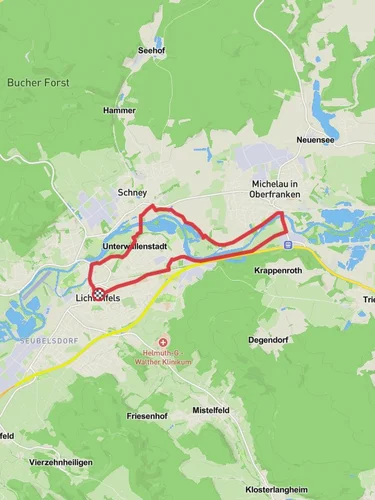
Starting near the picturesque town of Lichtenfels, Germany, the Aussichtstrum-Kroestner Gruendla trail is a delightful 7 km (4.35 miles) loop with an elevation gain of approximately 200 meters (656 feet). This medium-difficulty hike offers a blend of natural beauty, historical landmarks, and opportunities for wildlife spotting, making it a rewarding experience for both novice and seasoned hikers.
### Getting There To reach the trailhead, you can either drive or use public transport. If driving, head towards Lichtenfels and look for parking near the town center. For those using public transport, Lichtenfels is well-connected by train. From the Lichtenfels train station, it's a short walk to the trailhead, which is conveniently located near the town center.
### Trail Highlights As you embark on the trail, you'll first encounter a gentle ascent through a mixed forest of beech and oak trees. The forest floor is often carpeted with wildflowers in the spring, adding a splash of color to your hike. After about 1.5 km (0.93 miles), you'll reach the first significant landmark, the Aussichtsturm (Observation Tower). Climbing the tower offers panoramic views of the surrounding Franconian countryside, including the Main River and the distant hills of the Franconian Switzerland region.
### Historical Significance The region around Lichtenfels has a rich history dating back to the medieval period. As you continue along the trail, you'll come across remnants of old fortifications and ancient stone walls, which are believed to have been part of a medieval defensive system. These historical artifacts provide a fascinating glimpse into the area's past and are well worth a moment of exploration.
### Wildlife and Nature The trail is home to a variety of wildlife, including deer, foxes, and numerous bird species. Keep an eye out for the European green woodpecker, which is often seen flitting between the trees. The diverse flora includes not only the aforementioned wildflowers but also various types of ferns and mosses that thrive in the forest's humid environment.
### Navigation and Safety The trail is well-marked, but it's always a good idea to have a reliable navigation tool. HiiKER is an excellent app for this purpose, providing detailed maps and real-time GPS tracking to ensure you stay on course. The trail can be muddy after rain, so sturdy hiking boots are recommended. Additionally, some sections can be steep and rocky, so take care, especially if hiking with children or less experienced hikers.
### Final Stretch As you near the end of the loop, the trail descends gently back towards Lichtenfels. This section offers more open views of the surrounding farmland and small villages, providing a peaceful and scenic conclusion to your hike. The entire loop takes around 2-3 hours to complete, depending on your pace and how often you stop to take in the sights.
This trail offers a perfect blend of natural beauty, historical intrigue, and moderate physical challenge, making it a must-visit for anyone in the Lichtenfels area.
Reviews
User comments, reviews and discussions about the Aussichtstrum-Kroestner Gruendla, Germany.
0.0
average rating out of 5
0 rating(s)


