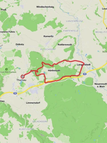
10.8 km
~2 hrs 40 min
310 m
“The Rundweg Roter Ring Thurnau offers a scenic, moderately challenging 11-kilometer hike through historic and natural Franconian beauty.”
Starting near the charming town of Kulmbach, Germany, the Rundweg Roter Ring Thurnau is a scenic loop trail that spans approximately 11 kilometers (about 6.8 miles) with an elevation gain of around 300 meters (approximately 984 feet). This trail is rated as medium difficulty, making it suitable for moderately experienced hikers.
### Getting There To reach the trailhead, you can either drive or use public transportation. If you're driving, head towards Kulmbach and look for parking near the town center or designated trail parking areas. For those using public transport, Kulmbach is well-connected by train and bus services. From the Kulmbach train station, you can take a local bus or taxi to the trailhead.
### Trail Highlights and Landmarks The trail begins near the historic town of Thurnau, known for its picturesque Thurnau Castle. As you start your hike, you'll pass through lush forests and open meadows, offering a mix of shaded and sunny sections. The first few kilometers are relatively gentle, allowing you to ease into the hike.
### Nature and Wildlife As you progress, you'll encounter a variety of flora and fauna. The forests are home to oak, beech, and pine trees, providing a habitat for local wildlife such as deer, foxes, and a variety of bird species. Keep an eye out for the colorful European robin and the elusive Eurasian jay.
### Mid-Trail Elevation and Views Around the 5-kilometer (3.1-mile) mark, the trail begins to ascend more steeply, gaining approximately 150 meters (492 feet) in elevation over the next 2 kilometers (1.2 miles). This section offers some of the most rewarding views, with panoramic vistas of the Franconian landscape. On clear days, you can see as far as the Fichtel Mountains.
### Historical Significance The region around Kulmbach and Thurnau is steeped in history. Thurnau Castle, which you can visit before or after your hike, dates back to the 13th century and has been meticulously preserved. The castle grounds and the nearby St. Laurentius Church are worth exploring for their architectural beauty and historical significance.
### Navigation and Safety For navigation, it's highly recommended to use the HiiKER app, which provides detailed maps and real-time updates. The trail is well-marked, but having a reliable navigation tool ensures you stay on track, especially in the more remote sections.
### Final Stretch The final part of the trail descends gradually back towards Thurnau, passing through more open fields and small streams. This section is less strenuous, allowing you to enjoy the serene countryside as you make your way back to the starting point.
### Practical Tips - Wear sturdy hiking boots, as some sections can be rocky and uneven. - Bring enough water and snacks, especially if you plan to take breaks and enjoy the scenery. - Check the weather forecast before you go, as conditions can change rapidly in this region. - If you're hiking in the fall, be prepared for cooler temperatures and potentially muddy trails.
This trail offers a delightful mix of natural beauty, historical landmarks, and moderate physical challenge, making it a rewarding experience for those looking to explore the Franconian countryside.
Reviews
User comments, reviews and discussions about the Rundweg Roter Ring Thurnau, Germany.
5.0
average rating out of 5
1 rating(s)


