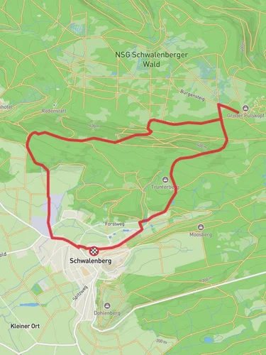
8.4 km
~2 hrs 3 min
232 m
“Discover the scenic and historical Bei Schwalenberg trail, a medium-difficulty 8 km loop in Kreis Lippe, Germany.”
Starting near Kreis Lippe, Germany, the Bei Schwalenberg trail offers an 8 km (approximately 5 miles) loop with an elevation gain of around 200 meters (656 feet). This medium-difficulty trail is perfect for those looking to experience the natural beauty and historical richness of the region.
### Getting There To reach the trailhead, you can drive or use public transport. If driving, set your GPS to Schwalenberg, a charming town in the Lippe district. For those using public transport, take a train to Schieder-Schwalenberg station and then a bus or taxi to Schwalenberg. The trailhead is conveniently located near the town center, making it easily accessible.
### Trail Overview The trail begins near the picturesque town of Schwalenberg, known for its half-timbered houses and artistic heritage. As you start your hike, you'll be greeted by a mix of dense forests and open meadows, offering a variety of landscapes to enjoy.
### Key Landmarks and Points of Interest - Schwalenberg Castle: Approximately 1 km (0.6 miles) into the hike, you'll come across the ruins of Schwalenberg Castle. This medieval fortress offers a glimpse into the region's history and provides a great spot for a short break. - Panoramic Views: Around the 3 km (1.9 miles) mark, the trail ascends to a viewpoint offering panoramic views of the surrounding countryside. This is one of the highest points on the trail, with an elevation gain of about 100 meters (328 feet) from the start. - Forest Trails: The middle section of the hike takes you through dense beech and oak forests. Keep an eye out for local wildlife, including deer and various bird species. The forested area is particularly beautiful in the autumn when the leaves change color. - Historic Markers: Scattered along the trail are several historical markers and information boards detailing the region's history, including its role in medieval trade routes.
### Navigation and Safety The trail is well-marked, but it's always a good idea to have a reliable navigation tool. HiiKER is an excellent app for this purpose, providing detailed maps and real-time tracking to ensure you stay on course.
### Flora and Fauna The trail is rich in biodiversity. In the spring and summer, you'll find a variety of wildflowers, including orchids and lilies. The forests are home to numerous bird species, so bringing a pair of binoculars could enhance your experience.
### Final Stretch As you near the end of the loop, the trail descends back towards Schwalenberg. The final 2 km (1.2 miles) are relatively easy, allowing you to cool down and enjoy the last views of the countryside.
### Practical Information - Best Time to Hike: Spring through autumn are the best seasons to hike this trail. Winter can be challenging due to snow and ice. - Facilities: Schwalenberg has several cafes and restaurants where you can enjoy a meal before or after your hike. Public restrooms are also available in the town center. - What to Bring: Comfortable hiking boots, water, snacks, and a camera for the stunning views and historical sites.
This trail offers a perfect blend of natural beauty and historical intrigue, making it a must-visit for any hiking enthusiast.
Reviews
User comments, reviews and discussions about the Bei Schwalenberg, Germany.
5.0
average rating out of 5
3 rating(s)


