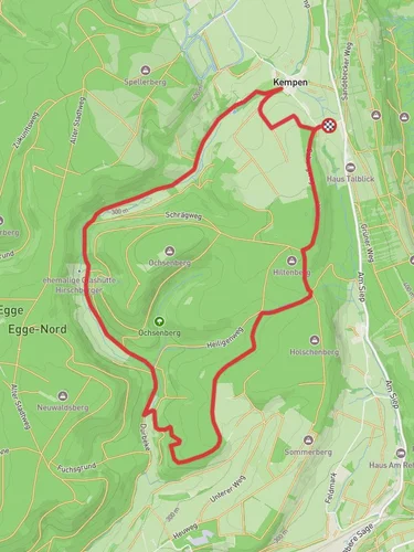
8.3 km
~2 hrs 1 min
215 m
“Explore lush forests, historic landmarks, and breathtaking vistas on this moderately challenging 9 km trail near Höxter.”
Starting near Kreis Höxter, Germany, this 9 km (approximately 5.6 miles) point-to-point trail offers a moderate challenge with an elevation gain of around 200 meters (656 feet). The trailhead is easily accessible by car or public transport. If driving, you can park near the town center of Höxter, which is well-signposted. For those using public transport, the nearest train station is Höxter Rathaus, from where you can catch a local bus or taxi to the trailhead.
### Trail Overview
The trail begins with a gentle ascent through lush forests, providing a serene start to your hike. As you progress, the path opens up to expansive meadows, offering panoramic views of the surrounding countryside. This initial section is relatively easy, making it a good warm-up for the more challenging parts ahead.
### Key Landmarks and Points of Interest
#### Historical Significance
Kreis Höxter is steeped in history, with roots dating back to medieval times. As you hike, you'll pass by several historical landmarks, including remnants of old fortifications and ancient farmhouses. Keep an eye out for informational plaques that provide context about the area's rich history.
#### Natural Beauty
Around the 3 km (1.9 miles) mark, you'll encounter a stunning viewpoint that offers a sweeping vista of the Weser River Valley. This is an excellent spot for a break and some photography. The trail then meanders through a mixed forest, where you might spot local wildlife such as deer, foxes, and a variety of bird species.
### Elevation and Terrain
The trail's elevation gain is gradual but consistent, with the most significant climb occurring between the 4 km (2.5 miles) and 6 km (3.7 miles) marks. Here, the path becomes steeper and rockier, requiring careful footing. Good hiking boots are recommended for this section.
### Navigation
To ensure you stay on track, it's advisable to use the HiiKER app, which provides detailed maps and real-time navigation. The trail is well-marked with signs, but having a digital backup can be invaluable, especially in the denser forested areas.
### Final Stretch
As you approach the final 2 km (1.2 miles), the trail descends gradually, leading you back into open fields and eventually to the endpoint near the village of Bruchhausen. This section is less strenuous, allowing you to enjoy the pastoral scenery and reflect on your hike.
### Getting Back
If you parked in Höxter, you can either hike back along the same route or arrange for a taxi from Bruchhausen. Public transport options are also available, with local buses connecting Bruchhausen to Höxter.
This trail offers a balanced mix of natural beauty, historical intrigue, and moderate physical challenge, making it a rewarding experience for hikers of all levels.
Reviews
User comments, reviews and discussions about the Auf Aussichtsreichen Hoehen and Rundwanderweg A1, Germany.
5.0
average rating out of 5
2 rating(s)


