10.5 km
~2 hrs 31 min
255 m
“The River Kall Streamside Loop offers a scenic 10 km hike rich in natural beauty and historical significance.”
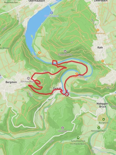
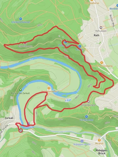
Starting near Kreis Düren, Germany, the River Kall Streamside Loop is a picturesque 10 km (6.2 miles) loop trail with an elevation gain of approximately 200 meters (656 feet). This medium-difficulty trail offers a blend of natural beauty and historical significance, making it a rewarding experience for hikers.
### Getting There To reach the trailhead, you can drive or use public transport. If driving, set your GPS to Kreis Düren, Germany, and look for parking near the trailhead. For public transport, take a train to Düren Station and then a local bus towards Zerkall. The nearest known landmark to the trailhead is the Zerkall train station, which is conveniently located for those arriving by public transport.
### Trail Overview The trail begins near the Zerkall train station and quickly immerses you in the serene beauty of the River Kall. The first section of the trail runs parallel to the river, offering stunning views of the water and the surrounding forest. The path is well-marked, but it's advisable to use HiiKER for navigation to ensure you stay on track.
### Significant Landmarks and Nature Around the 2 km (1.2 miles) mark, you'll encounter the first significant landmark: the ruins of an old mill. This site offers a glimpse into the region's industrial past and is a great spot for a short break and some photos. Continuing along the trail, you'll pass through dense forests and open meadows, each offering unique flora and fauna. Keep an eye out for deer, foxes, and a variety of bird species that inhabit the area.
### Elevation and Terrain The trail features a moderate elevation gain of 200 meters (656 feet), with the most significant climbs occurring between the 4 km (2.5 miles) and 6 km (3.7 miles) marks. These sections can be a bit challenging, but the well-maintained path and the occasional bench for resting make it manageable for most hikers.
### Historical Significance The region around the River Kall has a rich history, particularly from World War II. The trail passes near several historical sites, including old bunkers and memorials. These landmarks serve as poignant reminders of the past and add a layer of depth to your hiking experience.
### Final Stretch As you approach the final 2 km (1.2 miles) of the loop, the trail descends gently back towards the river. This section is particularly scenic, with the sound of flowing water accompanying you as you make your way back to the starting point near Zerkall train station.
### Preparation Tips Given the moderate difficulty of the trail, it's advisable to wear sturdy hiking boots and bring plenty of water. The trail can be muddy in sections, especially after rain, so be prepared for varying conditions. Using HiiKER for navigation will help you stay on course and make the most of your hike.
This trail offers a perfect blend of natural beauty, wildlife, and historical landmarks, making it a must-visit for any hiking enthusiast.
Reviews
User comments, reviews and discussions about the River Kall Streamside Loop - Zerkall, Germany.
0.0
average rating out of 5
0 rating(s)


