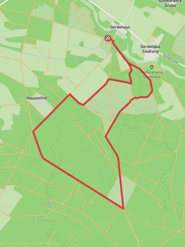
13.9 km
~2 hrs 52 min
60 m
“Explore the diverse landscapes and rich history of Heidekreis on the scenic Kartoffelweg trail.”
Starting near Heidekreis, Germany, this 14 km (approximately 8.7 miles) loop trail offers a delightful journey through the serene landscapes of Lower Saxony. With an elevation gain of around 0 meters, the Kartoffelweg is accessible to hikers of varying skill levels, though it is rated as medium difficulty due to its length and terrain.
### Getting There To reach the trailhead, you can drive or use public transport. If driving, set your GPS to Heidekreis, Germany, and look for parking near the Heidekreis district. For those using public transport, take a train to the nearest station in Heidekreis and then a local bus or taxi to the trailhead. The nearest significant landmark is the Heide Park Resort, a well-known amusement park in the area.
### Trail Navigation For navigation, it is highly recommended to use the HiiKER app, which provides detailed maps and real-time updates to ensure you stay on track throughout your hike.
### Trail Highlights The Kartoffelweg trail meanders through a variety of landscapes, including lush forests, open fields, and charming rural areas. Along the way, you'll encounter several notable landmarks and points of interest.
#### Forested Sections Approximately 3 km (1.9 miles) into the hike, you'll enter a dense forest area. This section is particularly enchanting, with tall trees providing ample shade and a rich undergrowth teeming with wildlife. Keep an eye out for deer and various bird species that inhabit this part of the trail.
#### Open Fields and Farmlands Around the 7 km (4.3 miles) mark, the trail opens up into expansive fields and farmlands. This part of the hike offers panoramic views of the surrounding countryside and is a great spot for a picnic. The fields are often dotted with wildflowers, especially in the spring and summer months.
### Historical Significance The Heidekreis region has a rich history, and the Kartoffelweg trail passes by several sites of historical interest. One such site is an old farmhouse located about 10 km (6.2 miles) into the hike. This farmhouse dates back to the 18th century and offers a glimpse into the agricultural heritage of the region.
### Wildlife and Flora The trail is home to a diverse range of flora and fauna. In the forested sections, you'll find a variety of tree species, including oak, beech, and pine. The open fields are often filled with wildflowers such as daisies, poppies, and cornflowers. Wildlife is abundant, with frequent sightings of deer, rabbits, and numerous bird species.
### Final Stretch As you approach the final 2 km (1.2 miles) of the trail, you'll pass through a picturesque village. This is a great opportunity to rest and perhaps visit a local café for a refreshing drink or a snack. The village also has several historical buildings worth exploring.
### Preparation Tips Given the trail's length and medium difficulty rating, it's advisable to bring plenty of water, snacks, and a good pair of hiking boots. The terrain is mostly flat, but some sections can be uneven, so sturdy footwear is essential. Also, consider bringing a hat and sunscreen, especially for the open field sections where shade is limited.
Using the HiiKER app will ensure you have the most accurate and up-to-date information, making your hike on the Kartoffelweg a memorable and enjoyable experience.
Reviews
User comments, reviews and discussions about the Kartoffelweg, Germany.
4.0
average rating out of 5
2 rating(s)


