9.4 km
~2 hrs 21 min
287 m
“Explore the Dahler Hoehenring and Rundweg Denkmalweg for scenic views and rich historical landmarks.”
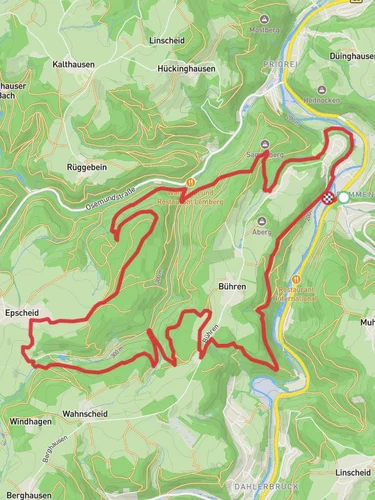
Starting near Hagen, Germany, the Dahler Hoehenring and Rundweg Denkmalweg is a picturesque loop trail that spans approximately 9 km (5.6 miles) with an elevation gain of around 200 meters (656 feet). This medium-difficulty trail offers a blend of natural beauty and historical significance, making it a rewarding experience for hikers.
### Getting There To reach the trailhead, you can drive or use public transport. If driving, set your GPS to the vicinity of Hagen, Germany, and look for parking near the trailhead. For those using public transport, take a train or bus to Hagen Hauptbahnhof (Hagen Central Station). From there, local buses can take you closer to the trailhead. Check the latest schedules and routes on local transit websites or apps.
### Trail Overview The trail begins with a gentle ascent, allowing you to ease into the hike. As you progress, you'll encounter a mix of forested areas and open meadows, providing a variety of landscapes. The initial part of the trail is well-marked, but it's advisable to use the HiiKER app for navigation to ensure you stay on course.
### Significant Landmarks Around the 2 km (1.2 miles) mark, you'll come across the first significant landmark, the Dahler Höhe. This elevated point offers panoramic views of the surrounding countryside, making it a perfect spot for a short break and some photography.
Continuing along the trail, you'll reach the Rundweg Denkmalweg section. This part of the trail is rich in historical significance. At approximately 4 km (2.5 miles), you'll find the Denkmal, a monument commemorating local historical events. Take some time to read the plaques and learn about the region's past.
### Flora and Fauna The trail is home to a diverse range of flora and fauna. In the spring and summer months, wildflowers bloom abundantly, adding vibrant colors to the landscape. Keep an eye out for local wildlife such as deer, foxes, and various bird species. The forested sections are particularly good for birdwatching, so bringing a pair of binoculars could enhance your experience.
### Elevation and Terrain The trail features a total elevation gain of around 200 meters (656 feet), with the most significant climbs occurring in the first half of the hike. The terrain varies from well-trodden paths to more rugged sections, so sturdy hiking boots are recommended. There are a few steep sections, but they are manageable with moderate fitness levels.
### Navigation and Safety While the trail is generally well-marked, using the HiiKER app will help you navigate more confidently. The app provides real-time updates and detailed maps, ensuring you stay on the right path. Always carry a basic first aid kit, sufficient water, and some snacks. Mobile reception can be spotty in certain areas, so inform someone of your plans before heading out.
### Final Stretch As you approach the final 2 km (1.2 miles) of the trail, the path descends gently back towards the starting point. This section offers a relaxing end to your hike, with more open views and a chance to reflect on the journey.
This trail offers a balanced mix of natural beauty and historical intrigue, making it a must-visit for hikers in the Hagen area.

Reviews
User comments, reviews and discussions about the Dahler Hoehenring and Rundweg Denkmalweg, Germany.
5.0
average rating out of 5
1 rating(s)