11.2 km
~2 hrs 18 min
44 m
“Discover the Vechteweg Loop: a scenic, wildlife-rich trail near Nordhorn, perfect for all hiking enthusiasts.”
Starting near Grafschaft Bentheim, Germany, the Vechteweg, An der Vechte and Marschweg Loop is an 11 km (approximately 6.8 miles) trail with no significant elevation gain, making it accessible for hikers of varying skill levels. The trailhead is conveniently located near the town of Nordhorn, which can be reached by car or public transport. If you're driving, you can park near the Nordhorn railway station. For those using public transport, Nordhorn is well-connected by regional trains and buses.
### Trail Overview
The loop trail offers a mix of scenic riverbanks, lush meadows, and historical landmarks. The Vechte River is a constant companion along much of the route, providing serene water views and opportunities to spot local wildlife such as ducks, herons, and even the occasional beaver. The trail is well-marked, but it's always a good idea to have a reliable navigation tool like HiiKER to ensure you stay on track.
### Key Sections and Landmarks
#### Vechte Riverbank (0-3 km / 0-1.9 miles) Starting from the trailhead near Nordhorn, the first section of the trail follows the Vechte River. This part of the trail is particularly picturesque, with the river meandering through the landscape. Keep an eye out for the old water mills that dot the riverbank, remnants of the region's historical reliance on water power.
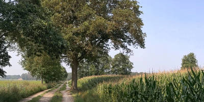
#### An der Vechte (3-6 km / 1.9-3.7 miles) As you continue, the trail transitions into the An der Vechte section. This area is characterized by expansive meadows and farmland. The flat terrain makes for easy walking, and the open fields offer unobstructed views of the surrounding countryside. This is a great spot for birdwatching, so bring your binoculars if you're a fan of avian life.
#### Marschweg (6-9 km / 3.7-5.6 miles) The Marschweg section takes you through more wooded areas, providing a change of scenery and a bit of shade. The path here is well-trodden and easy to follow. Look out for the ancient oak trees that have stood here for centuries, adding a touch of historical significance to your hike.
#### Return to Nordhorn (9-11 km / 5.6-6.8 miles) The final stretch of the loop brings you back towards Nordhorn. As you approach the town, you'll pass through a mix of residential areas and small parks. This section is a gentle end to your hike, allowing you to cool down and reflect on the diverse landscapes you've traversed.
### Historical Significance
The region around Grafschaft Bentheim has a rich history dating back to medieval times. The old water mills along the Vechte River are a testament to the area's historical reliance on water power for milling grain. Additionally, the ancient oak trees in the Marschweg section have witnessed centuries of history, standing as silent sentinels to the passage of time.
### Getting There
To reach the trailhead, you can drive to Nordhorn and park near the railway station. If you're using public transport, Nordhorn is accessible via regional trains and buses. From the station, it's a short walk to the start of the trail.
### Wildlife and Nature
The trail offers ample opportunities to observe local wildlife. Along the Vechte River, you might spot ducks, herons, and beavers. The meadows in the An der Vechte section are ideal for birdwatching, with various species of songbirds and raptors frequently seen. The wooded areas in the Marschweg section provide habitat for deer, foxes, and other woodland creatures.
### Navigation
While the trail is well-marked, using a navigation tool like HiiKER can help ensure you stay on the correct path and make the most of your hike.
Reviews
User comments, reviews and discussions about the Vechteweg, An der Vechte and Marschweg Loop, Germany.
0.0
average rating out of 5
0 rating(s)


