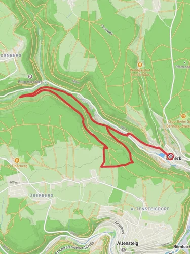
Hochdorfer Saegmuehle to Poppeltal via Fuenfbronn - Winterhalde
10.4 km
~2 hrs 39 min
356 m
“Discover the Black Forest's lush trails, historic sites, and wildlife on this 10 km scenic hike.”
Starting near Freudenstadt, Germany, this 10 km (approximately 6.2 miles) point-to-point trail offers a delightful mix of natural beauty and historical intrigue. The trailhead is conveniently accessible by both public transport and car. If you're taking public transport, you can catch a train to Freudenstadt Hauptbahnhof and then a local bus to the nearest stop, which is a short walk from the trailhead. For those driving, parking is available near the starting point.
### Initial Ascent and Forested Pathways
The trail begins with a gentle ascent, gaining around 300 meters (approximately 984 feet) in elevation. As you start your hike, you'll be enveloped by the lush greenery of the Black Forest. The initial section is relatively easy, making it a good warm-up for the more challenging parts ahead. Keep an eye out for the diverse flora, including towering pines and a variety of ferns that carpet the forest floor.
### Fuenfbronn and Historical Significance
Around the 3 km (1.9 miles) mark, you'll reach Fuenfbronn, a small but historically significant area. This region has been inhabited for centuries, and you might notice remnants of old mills and water channels that date back to medieval times. These historical landmarks offer a glimpse into the past, showcasing the ingenuity of early settlers who harnessed the power of water for their daily needs.
### Wildlife and Scenic Views
As you continue, the trail meanders through dense forest, opening up occasionally to offer stunning vistas of the surrounding landscape. This area is rich in wildlife; if you're lucky, you might spot deer, foxes, or even a wild boar. Birdwatchers will also find this section rewarding, with species like the European robin and the black woodpecker frequently making appearances.
### Winterhalde and Elevation Gain
Approaching the 7 km (4.3 miles) mark, you'll encounter Winterhalde, a more challenging section with steeper inclines. This part of the trail will test your endurance, but the effort is well worth it. The elevation gain here is more pronounced, and you'll ascend through a series of switchbacks that offer panoramic views of the Black Forest. Make sure to take breaks and hydrate, especially if you're hiking during warmer months.
### Final Stretch to Poppeltal
The last 3 km (1.9 miles) of the trail lead you downhill towards Poppeltal. This section is less strenuous, allowing you to enjoy the serene beauty of the forest as you descend. The trail here is well-marked, but it's always a good idea to have a reliable navigation tool like HiiKER to ensure you stay on track.
### Reaching Poppeltal
Upon reaching Poppeltal, you'll find yourself in a picturesque valley surrounded by rolling hills and dense forest. This area is perfect for a post-hike picnic or simply to relax and take in the natural beauty. Public transport options are available from Poppeltal to return to Freudenstadt, or you can arrange for a car pickup if you prefer.
This trail offers a balanced mix of natural beauty, historical landmarks, and moderate physical challenge, making it an excellent choice for hikers looking to explore the Black Forest region.
Reviews
User comments, reviews and discussions about the Hochdorfer Saegmuehle to Poppeltal via Fuenfbronn - Winterhalde, Germany.
0.0
average rating out of 5
0 rating(s)


