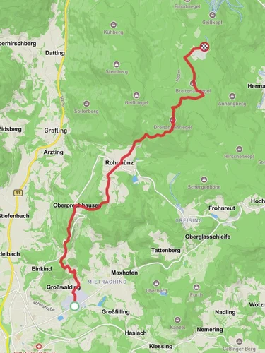
Neumuehle to Loderhart via Deggendorf Zielwanderweg
10.2 km
~3 hrs 16 min
732 m
“Experience the Bavarian Forest's rich history and stunning vistas on the moderately challenging Neumuehle to Loderhart trail.”
Starting near Deggendorf, Germany, the Neumuehle to Loderhart via Deggendorf Zielwanderweg trail offers a captivating journey through the Bavarian Forest. This point-to-point trail spans approximately 10 kilometers (6.2 miles) with an elevation gain of around 700 meters (2,297 feet), making it a moderately challenging hike suitable for those with a reasonable level of fitness.
### Getting There To reach the trailhead, you can either drive or use public transport. If driving, head towards Deggendorf and look for parking near Neumuehle. For those using public transport, Deggendorf is well-connected by train and bus services. From the Deggendorf train station, you can take a local bus or taxi to Neumuehle.
### Trail Overview The trail begins near Neumuehle, a quaint area that sets the tone for the scenic beauty ahead. As you start your hike, you'll be greeted by lush forests and the soothing sounds of the Isar River. The initial part of the trail is relatively gentle, allowing you to ease into the hike.
### Significant Landmarks and Nature Around the 2-kilometer (1.2-mile) mark, you'll encounter the first significant elevation gain as you ascend through dense woodland. Keep an eye out for local wildlife such as deer and various bird species. The Bavarian Forest is known for its rich biodiversity, so nature enthusiasts will find plenty to admire.
At approximately 4 kilometers (2.5 miles), you'll reach a scenic viewpoint offering panoramic views of the surrounding valleys and hills. This is an excellent spot for a short break and some photography. The elevation gain here is about 300 meters (984 feet), so take your time to enjoy the vistas.
### Historical Significance As you continue, you'll pass through areas steeped in history. The region around Deggendorf has a rich cultural heritage, with historical landmarks dating back to medieval times. The trail itself has been used for centuries, serving as a route for traders and travelers.
### Navigation and Safety The trail is well-marked, but it's always a good idea to have a reliable navigation tool. HiiKER is an excellent app for this purpose, providing detailed maps and real-time updates. Make sure to carry enough water and snacks, as there are limited facilities along the way.
### Final Stretch The final stretch of the trail involves a steep ascent towards Loderhart. This section is the most challenging, with an elevation gain of about 400 meters (1,312 feet) over the last 4 kilometers (2.5 miles). The effort is well worth it, as you'll be rewarded with stunning views and a sense of accomplishment upon reaching Loderhart.
### Wildlife and Flora Throughout the hike, you'll traverse through diverse ecosystems, from riverbanks to highland forests. The flora varies with elevation, featuring everything from lowland shrubs to alpine flowers. Keep an eye out for rare plant species that are native to this region.
### Ending the Hike Upon reaching Loderhart, you can relax and take in the beautiful surroundings. There are a few local inns and guesthouses where you can rest and enjoy some traditional Bavarian cuisine. From Loderhart, you can arrange for transportation back to Deggendorf or continue exploring the region.
This trail offers a perfect blend of natural beauty, historical significance, and physical challenge, making it a must-do for any hiking enthusiast visiting Bavaria.
Reviews
User comments, reviews and discussions about the Neumuehle to Loderhart via Deggendorf Zielwanderweg, Germany.
5.0
average rating out of 5
1 rating(s)


