14.8 km
~3 hrs 8 min
113 m
“The Rund um Langendreer trail blends urban charm and natural beauty, perfect for a scenic day hike.”
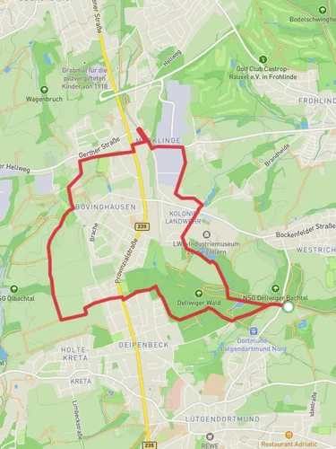
Starting near Bochum, Germany, the Rund um Langendreer trail is a scenic 15 km (approximately 9.3 miles) loop with an elevation gain of around 100 meters (328 feet). This medium-difficulty trail offers a delightful mix of urban and natural landscapes, making it a perfect day hike for those looking to explore the area.
### Getting There To reach the trailhead, you can use public transport or drive. If you're taking public transport, the nearest major landmark is the Bochum Hauptbahnhof (Bochum Central Station). From there, you can take a local bus or tram to Langendreer, which is well-connected and easy to navigate. If you're driving, there are several parking options available near the starting point in Langendreer.
### Trail Overview The trail begins in the charming district of Langendreer, a part of Bochum known for its historical significance and vibrant community. As you start your hike, you'll pass through residential areas that quickly give way to more natural surroundings. The first few kilometers are relatively flat, allowing you to ease into the hike.
### Key Landmarks and Nature Around the 3 km (1.9 miles) mark, you'll encounter the Langendreer Markt, a bustling local market that offers a glimpse into the daily life of the residents. This is a great spot to take a short break and perhaps grab a snack.
Continuing on, the trail leads you into the Langendreer Holz, a beautiful forested area that provides a serene escape from the urban environment. The forest is home to a variety of wildlife, including deer, foxes, and numerous bird species. Keep an eye out for the European robin and the great spotted woodpecker, both commonly seen here.
### Historical Significance As you hike through the forest, you'll come across remnants of old coal mining operations, a nod to the region's industrial past. The Ruhr area, where Bochum is located, was once a major coal mining hub, and these historical sites offer a fascinating glimpse into that era.
### Navigation and Terrain The trail is well-marked, but it's always a good idea to have a reliable navigation tool like HiiKER to ensure you stay on track. The terrain varies from paved paths in the urban sections to dirt trails in the forested areas. There are a few gentle inclines, but nothing too strenuous, making it accessible for most hikers.
### Final Stretch As you approach the final stretch of the hike, you'll pass through the Kemnader See, a picturesque lake that offers opportunities for bird watching and a peaceful spot to rest. The trail then loops back towards Langendreer, where you can explore more of the local shops and cafes before concluding your hike.
### Practical Tips - Wear comfortable hiking shoes suitable for mixed terrain. - Bring water and snacks, especially if you plan to take breaks at the various landmarks. - Check the weather forecast and dress appropriately. - Use HiiKER for navigation to ensure you stay on the correct path.
This trail offers a wonderful blend of natural beauty, historical significance, and local culture, making it a rewarding experience for any hiker.
Reviews
User comments, reviews and discussions about the Rund um Langendreer, Germany.
0.0
average rating out of 5
0 rating(s)


