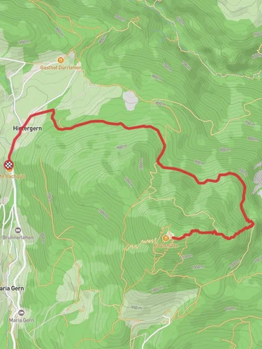
9.1 km
~2 hrs 47 min
579 m
“Experience breathtaking views, diverse landscapes, and historical insights on the scenic 9 km AV Weg and Maximiliansweg trail.”
Starting near Berchtesgadener Land, Germany, this 9 km (5.6 miles) loop trail offers a moderate challenge with an elevation gain of around 500 meters (1,640 feet). The trailhead is conveniently accessible by both public transport and car. If you're using public transport, you can take a bus to the Berchtesgaden Hauptbahnhof, from where local buses or taxis can take you closer to the trailhead. For those driving, parking is available near the trail's starting point.
### Trail Overview
The AV Weg and Maximiliansweg trail is a scenic loop that takes you through the picturesque landscapes of the Berchtesgadener Land region. The trail is well-marked and offers a variety of terrains, including forest paths, open meadows, and rocky sections. Hikers should be prepared for some steep ascents and descents, but the effort is well worth it for the stunning views and natural beauty along the way.
### Key Landmarks and Points of Interest
1. Königssee: Approximately 2 km (1.2 miles) into the hike, you'll come across a viewpoint offering breathtaking views of Königssee, a crystal-clear alpine lake surrounded by towering mountains. This is a great spot to take a break and soak in the scenery.
2. Jennerbahn Cable Car: Around the 4 km (2.5 miles) mark, you'll pass near the Jennerbahn cable car station. This is a popular spot for tourists, and you might encounter more people here. The cable car offers an alternative way to explore the higher elevations if you're interested in extending your adventure.
3. Historical Significance: The trail also passes through areas of historical significance. During World War II, the Berchtesgadener Land region was home to several Nazi leaders, including Adolf Hitler. The remnants of this dark history can still be seen in some parts of the region, adding a layer of historical context to your hike.
### Flora and Fauna
The trail is rich in biodiversity. As you hike through the dense forests, keep an eye out for native wildlife such as deer, foxes, and various bird species. The flora is equally impressive, with a variety of alpine flowers, mosses, and ferns lining the path. In the spring and summer months, the meadows burst into a riot of colors with wildflowers in full bloom.
### Navigation and Safety
Given the moderate difficulty of the trail, it's advisable to use a reliable navigation tool like HiiKER to keep track of your progress and ensure you stay on the right path. The trail is generally well-marked, but having a digital map can be very helpful, especially in the more remote sections.
### Getting There
To reach the trailhead, you can take a bus to Berchtesgaden Hauptbahnhof and then a local bus or taxi to the starting point. If you're driving, parking is available near the trailhead. The nearest significant landmark to the trailhead is the Berchtesgaden National Park Visitor Center, which is a good place to gather additional information and use restroom facilities before starting your hike.
### Final Tips
- Wear sturdy hiking boots with good ankle support. - Bring plenty of water and snacks, as there are limited facilities along the trail. - Check the weather forecast before you go, as conditions can change rapidly in the mountains. - Be mindful of the local wildlife and respect their habitat.
This trail offers a perfect blend of natural beauty, historical significance, and moderate physical challenge, making it a rewarding experience for any hiker.
Reviews
User comments, reviews and discussions about the AV Weg and Maximiliansweg, Germany.
0.0
average rating out of 5
0 rating(s)


