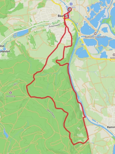
9.8 km
~2 hrs 13 min
153 m
“Embark on the scenic Breitengüßbach Rundwanderweg 2, a 10 km trail rich in nature and history.”
Starting near the charming town of Breitengüßbach, close to Bamberg in Germany, the Breitengüßbach Rundwanderweg 2 is a delightful loop trail that spans approximately 10 kilometers (6.2 miles) with an elevation gain of around 100 meters (328 feet). This trail is rated as medium difficulty, making it suitable for hikers with a moderate level of fitness.
### Getting There To reach the trailhead, you can either drive or use public transport. If you're driving, head towards Breitengüßbach, which is easily accessible via the A73 motorway. There are parking facilities available near the start of the trail. For those using public transport, take a train to Breitengüßbach station. From there, it's a short walk to the trailhead.
### Trail Navigation For navigation, it's highly recommended to use the HiiKER app, which provides detailed maps and real-time updates to ensure you stay on the right path.
### Trail Highlights As you embark on this loop trail, you'll be greeted by a mix of scenic landscapes, including lush forests, open meadows, and picturesque farmlands. The trail is well-marked, but always keep an eye out for the distinctive trail markers to stay on course.
#### Nature and Wildlife The trail offers a rich tapestry of flora and fauna. In the spring and summer months, the meadows are adorned with wildflowers, attracting a variety of butterflies and bees. Birdwatchers will be delighted by the presence of species such as the European robin, blackbird, and occasionally, the elusive Eurasian jay. The forested sections provide a cool respite and are home to deer, foxes, and a variety of small mammals.
#### Historical Significance The region around Breitengüßbach is steeped in history. As you hike, you'll come across several historical landmarks. One notable site is the St. Leonhard's Chapel, located approximately 4 kilometers (2.5 miles) into the hike. This charming chapel dates back to the 14th century and offers a glimpse into the region's medieval past. Another point of interest is the old mill near the 7-kilometer (4.3 miles) mark, which has been beautifully preserved and provides insight into the traditional milling practices of the area.
### Elevation and Terrain The trail features a gentle elevation gain of around 100 meters (328 feet), making it manageable for most hikers. The terrain is varied, with some sections being relatively flat and others featuring gentle inclines. The path is a mix of dirt trails, gravel paths, and occasional paved sections, so sturdy hiking shoes are recommended.
### Points of Interest - St. Leonhard's Chapel: A historical chapel dating back to the 14th century, located about 4 kilometers (2.5 miles) into the hike. - Old Mill: A beautifully preserved mill near the 7-kilometer (4.3 miles) mark, offering a glimpse into traditional milling practices.
### Practical Tips - Water and Snacks: There are no facilities along the trail, so be sure to carry enough water and snacks to keep you energized. - Weather: Check the weather forecast before you set out. The trail can become muddy and slippery after rain, so appropriate footwear is essential. - Wildlife: While the wildlife is generally harmless, it's always a good idea to keep a respectful distance from any animals you encounter.
By following these guidelines and using the HiiKER app for navigation, you'll be well-prepared to enjoy the Breitengüßbach Rundwanderweg 2 and all the natural beauty and historical richness it has to offer.
Reviews
User comments, reviews and discussions about the Breitengüßbach Rundwanderweg 2, Germany.
0.0
average rating out of 5
0 rating(s)


