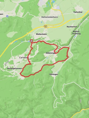
9.9 km
~2 hrs 18 min
198 m
“Explore a scenic, historical 10 km trail near Bad Dürkheim, blending nature, Roman ruins, and local wine.”
Starting near the picturesque town of Bad Dürkheim in Germany, this 10 km (6.2 miles) loop trail offers a delightful mix of natural beauty and historical intrigue. With an elevation gain of around 100 meters (328 feet), the trail is rated as medium difficulty, making it accessible for most hikers with a moderate level of fitness.
### Getting There To reach the trailhead, you can either drive or use public transport. If driving, head towards Bad Dürkheim and look for parking options near the town center. For those using public transport, take a train to Bad Dürkheim station. From there, it's a short walk to the trailhead, which is conveniently located near the town's main attractions.
### Trail Highlights As you embark on this loop trail, you'll first encounter the serene Rothbach stream. The gentle babbling of the water sets a calming tone for the hike. The trail meanders through the lush Pfaelzerwald forest, known for its dense canopy of deciduous trees, particularly oaks and beeches. This forest is part of the larger Palatinate Forest-North Vosges Biosphere Reserve, a UNESCO-designated area known for its biodiversity.
### Historical Significance The region around Bad Dürkheim is steeped in history. As you hike, you'll come across remnants of ancient Roman settlements. The area was once a significant part of the Roman Empire, and you can still find ruins and artifacts that date back to this period. Keep an eye out for informational plaques that provide context and historical background.
### Wildlife and Flora The Pfaelzerwald forest is home to a variety of wildlife. You might spot deer, wild boar, and a plethora of bird species, including woodpeckers and owls. The forest floor is often carpeted with wildflowers, especially in the spring and early summer, adding a splash of color to your hike.
### Navigation and Waypoints For navigation, it's highly recommended to use the HiiKER app, which provides detailed maps and real-time updates. The trail is well-marked with white point (Weisser Punkt) signs, but having a reliable navigation tool ensures you stay on track.
### Notable Landmarks Around the halfway point, you'll reach the Karstweiher, a small but beautiful karst pond. This is an excellent spot to take a break and enjoy a picnic. The pond is surrounded by limestone formations, which are characteristic of the region's geology.
### Final Stretch As you loop back towards Bad Dürkheim, the trail offers stunning views of the surrounding vineyards. The town is famous for its wine production, and you might even catch a glimpse of local vintners at work. The final stretch of the trail descends gently back into the town, where you can reward yourself with a visit to one of the local wineries or a stroll through the charming streets of Bad Dürkheim.
This trail offers a perfect blend of natural beauty, historical significance, and moderate physical challenge, making it a must-do for any hiking enthusiast visiting the region.
Reviews
User comments, reviews and discussions about the Rothbach and Karstweiher via Pfaelzerwald Weisser Punkt, Germany.
4.0
average rating out of 5
2 rating(s)


