6.6 km
~1 hrs 34 min
149 m
“Explore Spring Wood's lush trails, historic Whalley Abbey, and scenic River Calder on this 7 km adventure!”
Starting near Lancashire, England, the Spring Wood and Whalley Country Park Loop is a delightful 7 km (approximately 4.3 miles) trail with an elevation gain of around 100 meters (328 feet). This loop trail is rated as medium difficulty, making it suitable for moderately experienced hikers.
### Getting There To reach the trailhead, you can drive or use public transport. If driving, set your GPS to Spring Wood Picnic Site, Whalley Road, Clitheroe BB7 9TD, which is the nearest known address. There is ample parking available at the picnic site. For those using public transport, the nearest train station is Whalley, which is about 1.5 km (0.9 miles) from the trailhead. From the station, you can either walk or take a local taxi to the starting point.
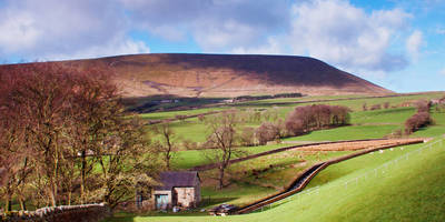
### Trail Overview The trail begins at the Spring Wood Picnic Site, a popular spot for families and nature enthusiasts. As you start your hike, you'll be greeted by a lush woodland area, home to a variety of native trees such as oak, ash, and beech. The first section of the trail is relatively flat, making it a gentle introduction to the hike.
### Key Landmarks and Points of Interest - Spring Wood: Approximately 1 km (0.6 miles) into the hike, you'll find yourself deep in Spring Wood. This area is known for its rich biodiversity, including various bird species like woodpeckers and nuthatches. Keep an eye out for the informative plaques that provide details about the local flora and fauna. - Whalley Abbey: Around the 3 km (1.9 miles) mark, you'll come across the ruins of Whalley Abbey. This 14th-century Cistercian abbey offers a glimpse into the region's historical significance. The ruins are well-preserved, and there are several information boards that detail the abbey's history and its role in the local community. - River Calder: As you continue, the trail will lead you to the banks of the River Calder. This section offers stunning views and is a great spot for a short break. The river is home to various fish species and is a popular spot for local anglers.
### Elevation and Terrain The trail features a gradual elevation gain of around 100 meters (328 feet). The most significant ascent occurs between the 4 km (2.5 miles) and 5 km (3.1 miles) marks, where the trail climbs through a series of switchbacks. This section can be a bit challenging, but the panoramic views from the top are well worth the effort.
### Wildlife and Nature The Spring Wood and Whalley Country Park Loop is a haven for wildlife enthusiasts. In addition to the bird species mentioned earlier, you may also encounter deer, foxes, and various small mammals. The trail is particularly beautiful in the spring when wildflowers like bluebells and primroses are in full bloom.
### Navigation For navigation, it's highly recommended to use the HiiKER app, which provides detailed maps and real-time updates. The trail is well-marked, but having a reliable navigation tool can enhance your hiking experience and ensure you stay on the right path.
### Final Stretch The final section of the trail loops back towards the Spring Wood Picnic Site. This part of the hike is relatively easy, with a gentle descent through open meadows and woodland. As you approach the end, you'll pass by several picnic areas, making it a perfect spot to relax and enjoy a post-hike meal.
This trail offers a perfect blend of natural beauty, historical landmarks, and moderate physical challenge, making it a rewarding experience for any hiker.
Reviews
User comments, reviews and discussions about the Spring Wood and Whalley Country Park Loop, England.
5.0
average rating out of 5
3 rating(s)
Loading reviews...


