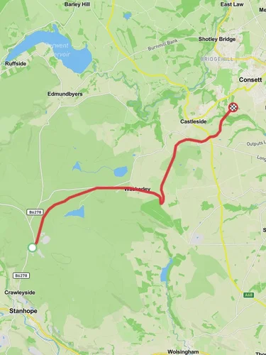
5.5 km
~1 hrs 19 min
137 m
“The Stanhope Burn Geotrail blends geological wonders, historical landmarks, and diverse wildlife into a captivating 5 km hike.”
Starting near County Durham, England, the Stanhope Burn Geotrail is a captivating 5 km (approximately 3.1 miles) loop trail with an elevation gain of around 100 meters (328 feet). This medium-difficulty trail offers a blend of geological wonders, historical landmarks, and diverse wildlife, making it a rewarding experience for hikers.
### Getting There To reach the trailhead, you can drive or use public transport. If driving, head towards Stanhope in County Durham. The nearest significant landmark is the Stanhope Station on the Weardale Railway, which is a convenient point to start your journey. For those using public transport, the Weardale Railway offers services to Stanhope Station, and from there, it's a short walk to the trailhead.
### Trail Highlights As you embark on the Stanhope Burn Geotrail, you'll traverse a variety of landscapes, from lush woodlands to open moorlands. The trail is well-marked, but it's advisable to use HiiKER for navigation to ensure you stay on track.
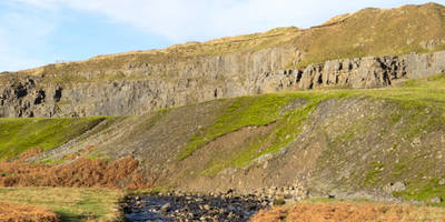
#### Geological Features One of the most striking aspects of this trail is its geological significance. The area is renowned for its rich geological history, with rock formations dating back to the Carboniferous period. Look out for the exposed limestone and sandstone layers, which tell a story of ancient seas and river systems. The Stanhope Burn itself has carved a picturesque valley through these rocks, creating a series of small waterfalls and rapids that are particularly stunning after rainfall.
#### Historical Landmarks The trail also offers a glimpse into the region's industrial past. About halfway through the loop, you'll come across the remnants of old lead mining operations. These ruins are a testament to the area's mining heritage, which dates back to the 18th and 19th centuries. Informational plaques along the trail provide insights into the lives of the miners and the techniques they used.
### Flora and Fauna The Stanhope Burn Geotrail is a haven for nature enthusiasts. The diverse habitats support a wide range of wildlife. In the woodlands, you might spot red squirrels, roe deer, and a variety of bird species, including woodpeckers and owls. The open moorlands are home to grouse and skylarks, and in the spring and summer, the area bursts into color with wildflowers such as bluebells and heather.
### Practical Information The trail is accessible year-round, but the best times to visit are in the spring and autumn when the weather is mild, and the scenery is at its most vibrant. Wear sturdy hiking boots, as parts of the trail can be muddy, especially after rain. Bring water and snacks, as there are no facilities along the trail.
### Navigation While the trail is generally well-marked, using HiiKER can enhance your hiking experience by providing detailed maps and real-time navigation. This is particularly useful if you wish to explore some of the less-trodden paths or learn more about the geological and historical points of interest along the way.
The Stanhope Burn Geotrail offers a rich tapestry of natural beauty, geological intrigue, and historical depth, making it a must-visit for hikers in the County Durham area.

Reviews
User comments, reviews and discussions about the Stanhope Burn Geotrail, England.
5.0
average rating out of 5
5 rating(s)