Download
3D Flyover
Add to list
More
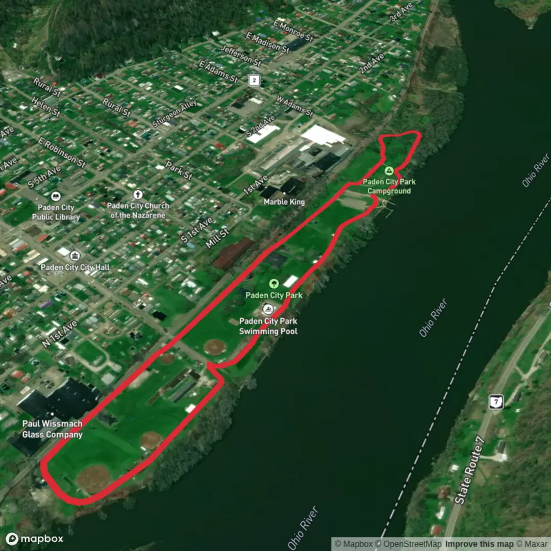
2.4 km
~28 min
0 m
Loop
“A breezy, mostly level park loop with benches, big-sky river vibes, and easy shortcuts.”
A short, flat park stroll of about 2 km (1.2 mi) with essentially 0 m (0 ft) of climbing, this loop is ideal for a low-effort walk, a quick leg-stretcher, or a family-friendly outing. Expect paved paths and/or well-worn park walkways, frequent benches and open sightlines, and easy options to shorten the walk if needed.
Getting to the start (car + public transport)
By car: Paden City sits along WV-2 on the Ohio River in Wetzel County, West Virginia. For the most reliable “drop-a-pin” start, aim for Paden City Park / the city park area near downtown Paden City, close to the riverfront and WV-2. Parking is typically available in or adjacent to the park and nearby streets; on event days (ballgames, festivals), arrive a little earlier to avoid full lots.
By public transport: This part of the Ohio River valley has limited fixed-route transit. The most practical approach is usually: - Intercity bus to a larger hub (often the Parkersburg/Marietta or Wheeling area depending on schedules), then - Rideshare/taxi to Paden City. If you’re trying to go fully car-free, check the most current regional bus options before committing, and build in extra time—service can be infrequent.
If you share the lon/lat for the trailhead, I can convert it to the nearest known address/landmark precisely and tailor the approach directions.
What the loop is like underfoot
Because the route is essentially flat, the main “effort” comes from pace rather than elevation. Surfaces are commonly paved or hard-packed, so regular walking shoes are usually enough in dry weather. After rain, watch for slick patches under trees, muddy edges where grass meets pavement, and occasional puddling in low spots.
Plan on 30–45 minutes at a relaxed pace for 2 km (1.2 mi), longer if you’re stopping for photos, playground time, or river views.
Navigation and wayfinding (keep it simple)
This is a park loop, so navigation is generally straightforward: follow the main path network and keep an eye on junctions where paths split around fields, courts, or picnic areas. If you want a clean track and distance readout, load the route on HiiKER and use it to confirm you’re staying on the intended loop—especially helpful if you decide to add a spur to a viewpoint, sports complex, or riverside segment.
Landmarks, scenery, and what to notice
You’ll likely pass a mix of open lawns, shade trees, and community recreation areas (playgrounds, ballfields, courts, picnic shelters). The Ohio River valley setting often means: - Broad, open sky over the river corridor and a sense of “big water” nearby - Mature riparian trees (species vary, but expect common river-bottom hardwoods and planted park trees) - Seasonal color: spring blossoms, summer canopy shade, and strong fall foliage in the surrounding hills
If the loop includes a river-adjacent segment, pause for a look at the working-river landscape—barge traffic and industrial history are part of the Ohio River’s identity, and you may see evidence of that in the broader views even from a quiet park path.
Wildlife and nature (what you’re most likely to encounter)
In a town park along a major river corridor, wildlife tends to be approachable and most active early/late in the day: - Birdlife: songbirds in the trees; near water you may spot waterfowl and other river birds depending on season. - Small mammals: squirrels are common; you may see rabbits near field edges. - Insects/ticks: in warm months, expect mosquitoes near shaded, damp areas and ticks in taller grass at the margins—stay on the main path, avoid brushing through unmown edges, and do a quick tick check afterward.
Keep dogs leashed—parks often have families, and wildlife is more likely to keep its distance.
Regional context and historical significance
Paden City and the surrounding Ohio River valley are part of a region shaped by river transportation, industry, and small-town Appalachian/Ohio Valley culture. The Ohio River has long been a major corridor for movement of people and goods, influencing settlement patterns and local economies. Even on a simple park loop, you’re walking in a landscape tied to that larger river history—towns here often grew around access to the river and the main north–south routes that parallel it.
Practical prep for an easy 2 km (1.2 mi) loop
- Water: usually optional for such a short, flat walk, but bring a small bottle in hot/humid weather.
- Footwear: comfortable walking shoes; consider grippier soles if it’s wet.
- Sun/heat: open lawns can be surprisingly sunny—hat and sunscreen help.
- Restrooms: often available in parks seasonally or near recreation facilities; if they’re closed, downtown businesses may be your backup.
- Accessibility: the flat profile and likely paved surfaces can suit strollers and many mobility needs, though curb cuts and surface condition vary by entrance.
If you provide the exact starting point (lon/lat) and whether you want the loop to prioritize riverfront views vs. interior park paths, I can describe the turn-by-turn flow with more precise distance callouts (e.g., “after 0.4 km / 0.25 mi, keep left at the split”) and identify the nearest named landmark/address for the trailhead.

Surfaces
Asphalt
Unknown
Comments and Reviews
User comments, reviews and discussions about the Paden City Park Loop, West Virginia.
average rating out of 5
0 rating(s)