Download
3D Flyover
Add to list
More
5.5 km
~1 hrs 6 min
0 m
Out and Back
“Stroll the Ohio River’s flat, breezy pavement, where industry meets birdlife in easy-going reflection.”
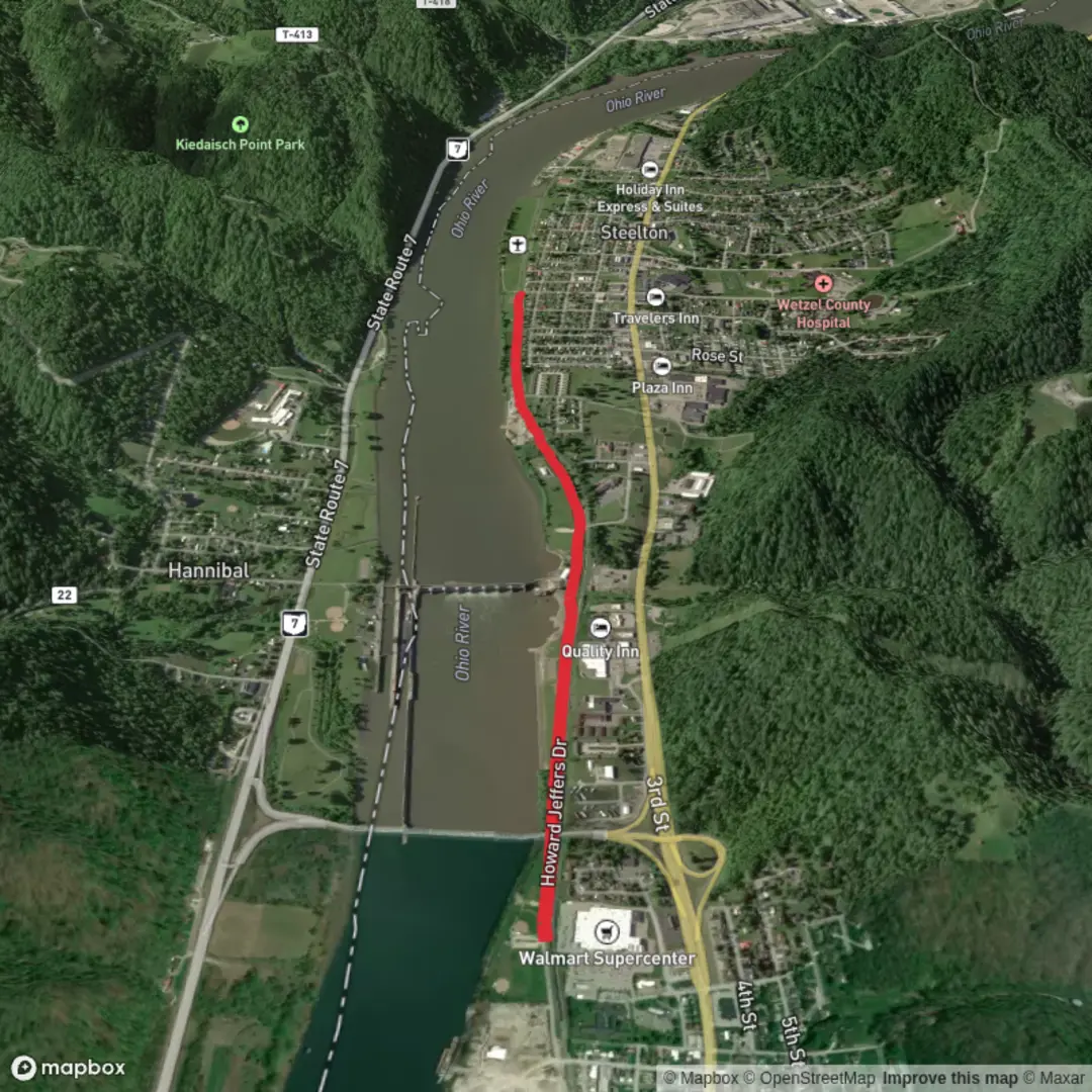
This is a flat, paved multi-use path that’s ideal for an easy out-and-back or a relaxed point-to-point walk, totaling about 6 km (3.7 mi) with essentially 0 m (0 ft) of elevation gain. Because it follows the Ohio River valley floor, the grade stays gentle and consistent—great for walkers, runners, strollers, and most mobility devices (surface and maintenance conditions can vary seasonally).
Getting to the start (car + public transport)
Trailhead area: The city describes the start as the north end of Howard Jeffers Drive (also called “Hydro Drive”) in New Martinsville. (newmartinsville.com)
A reliable landmark to navigate to is the New Martinsville Hannibal Hydroelectric Plant area, which is associated with 1 Howard Jeffers Dr, New Martinsville, WV 26155. (dep.wv.gov) From there, you’ll be at the riverfront/industrial edge where the walking trail begins.
- By car: Use HiiKER to route to 1 Howard Jeffers Dr, New Martinsville, WV 26155 (or “Howard Jeffers Drive / Hydro Drive” if that’s how it appears). Parking is typically easiest near the riverfront access points and adjacent public areas; if a lot is full, look for nearby street parking where permitted.
- By public transport: New Martinsville is a small Ohio River city and fixed-route transit options can be limited. Plan on a regional bus/taxi/rideshare approach: get to downtown New Martinsville first, then connect to the Hydro Drive riverfront area. If you’re coming from farther away, you’ll generally be linking in via larger nearby hubs (e.g., Wheeling area) and finishing the last miles by rideshare.
What the walk is like (surface, feel, and pacing)
Expect a straightforward, low-stress route with long sightlines and minimal wayfinding complexity. The walking trail is commonly done as: - Out-and-back: Walk 3 km (1.85 mi) out, then return the same way for 6 km (3.7 mi). - One-way with pickup: If you arrange a shuttle, you can treat it as a point-to-point.
Because the corridor is open and low-lying, wind off the Ohio River can be noticeable, especially in cooler months. In summer, the flat pavement can feel warmer than shaded woodland trails—bring water even though the distance is modest.
Landmarks and local context along the route
You’ll be walking in a landscape shaped by the Ohio River’s working-waterfront history. New Martinsville sits directly on the Ohio River and developed as a river town and county seat; over time, transportation and industry (including rail and river commerce) strongly influenced where the town grew. (britannica.com)
A major piece of river infrastructure nearby is the Hannibal Locks and Dam, a U.S. Army Corps of Engineers facility on the Ohio River at Hannibal, Ohio / New Martinsville, West Virginia. (en.wikipedia.org) Even if you don’t walk directly onto dam property, you’ll feel the “big river engineering” presence in the area—wide channels, industrial edges, and river traffic patterns.
If you have extra time before or after your walk, New Martinsville also has recognized historic areas close to downtown, including the North Street Historic District. (en.wikipedia.org) That’s a good option if you want to add a short architectural/history stroll without adding meaningful elevation.
Nature and wildlife to look for
This is a river-valley walk, so the “wildlife moments” tend to come from the riparian (river-edge) environment rather than deep forest: - Birdlife: Watch the river for waterfowl and wading birds; scan overhead for gulls/terns and seasonal migrants using the river as a travel corridor. - Riverbank activity: You may spot turtles sunning on logs or rocks in warmer months, and occasional fish activity near calmer edges. - Plants: Expect a mix of maintained edges and hardy riverbank vegetation; after high water, you may see drift lines of natural debris that show how far the river can rise.
Things to watch out for (practical safety)
- Flooding and wet patches: The Ohio River can rise quickly after heavy rain upstream. Low sections near the river can hold water or silt—wear shoes with decent grip even on pavement.
- Sun and heat exposure: With limited shade in places, bring water and consider a hat/sunscreen.
- **

Comments and Reviews
User comments, reviews and discussions about the New Martinsville Walking Trail, West Virginia.
average rating out of 5
0 rating(s)