Download
3D Flyover
Add to list
More
1.6 km
~21 min
21 m
Point-to-Point
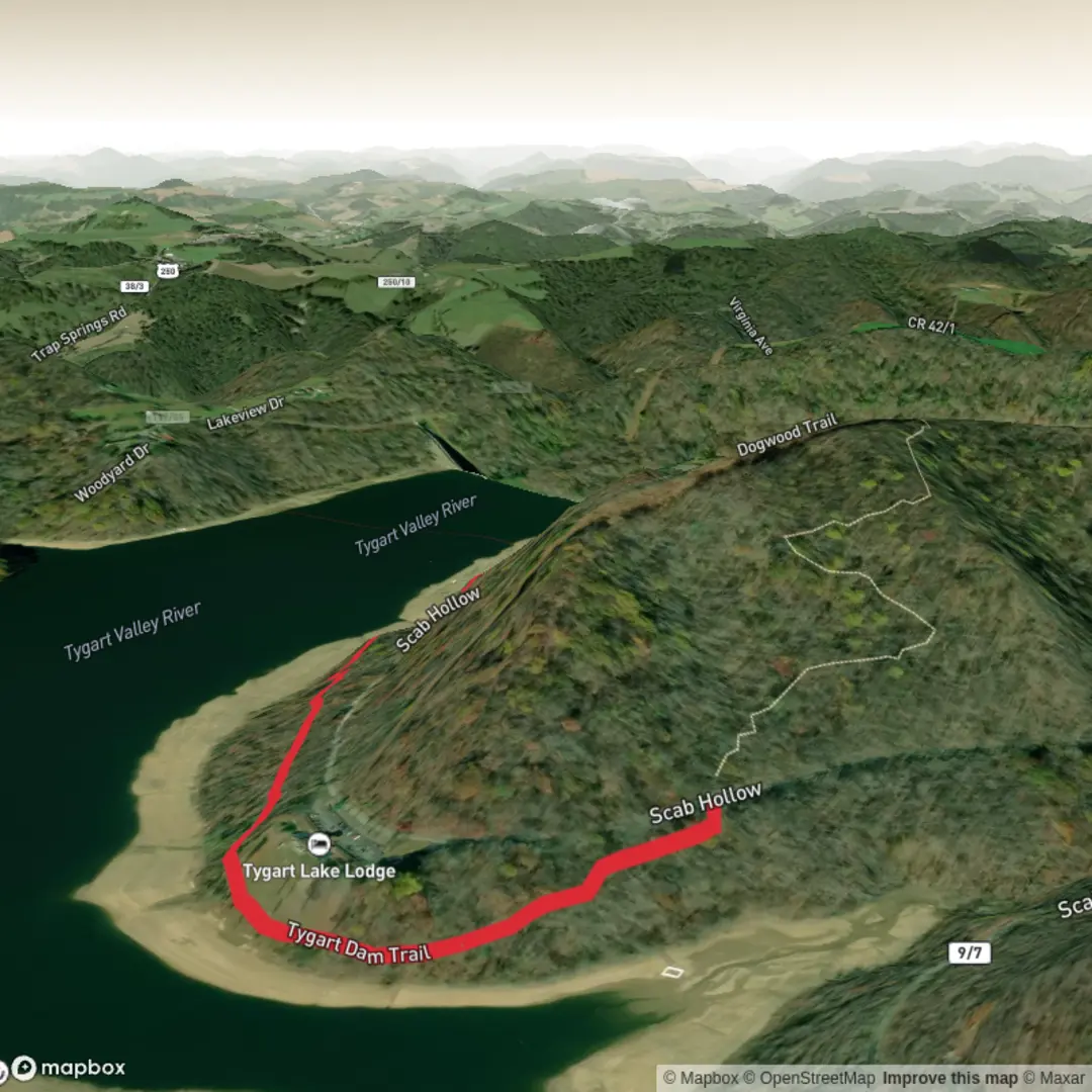
“From the lodge, wander gentle, rolling shoreline paths to Tygart Dam, where lake-glass views linger.”
This is a short, lakeside walk in Tygart Lake State Park near Grafton, West Virginia, linking the Tygart Lake State Park Lodge area to Tygart Dam. Expect a mostly well-defined footpath with gentle ups and downs rather than sustained climbing—ideal for families, casual walkers, and anyone looking for an easy leg-stretcher with water views. The park lists the route as 0.75 mi (1.2 km) one-way from the lodge area to the dam, so an out-and-back is typically about 1.5 mi (2.4 km). (wvstateparks.com)
Getting to the start (car + public transport)
By car: Aim for Tygart Lake State Park, whose main contact address is 1240 Paul E. Malone Rd, Grafton, WV 26354. From there, follow signs toward the lodge; the Dam Trail begins near the lodge area and heads toward the dam. (wvstateparks.com)
By public transport: There isn’t a straightforward, frequent transit option directly into the park. The most practical approach is usually to get to Grafton, WV (via regional bus/rail options depending on your origin) and then use a taxi/rideshare to reach Tygart Lake State Park Lodge / Paul E. Malone Road. Plan for limited cell service in pockets around the lake and have your pickup point saved in HiiKER before you arrive.
On-trail character (surface, grade, and pacing)
From the lodge area, the trail trends along the lakeshore corridor toward the dam. Even though it’s rated easy, “easy” here means short and non-technical, not perfectly flat: you’ll encounter a few rolling hills and occasional uneven footing typical of packed dirt/gravel with roots and small rocks. (wvstateparks.com)
- Distance: ~0.75 mi (1.2 km) one-way; ~1.5 mi (2.4 km) out-and-back
- Elevation gain: commonly modest; if you track it in HiiKER, expect small cumulative gain from the rollers rather than a single climb (often on the order of a few dozen metres at most for the full out-and-back, depending on exact start point and GPS smoothing).
A comfortable pace for most hikers is 30–60 minutes round trip, plus time for dam viewpoints and photos.
Landmarks and what to watch for
Lakeshore viewpoints: Much of the appeal is the constant proximity to Tygart Lake—look for openings through the trees where the shoreline curves and you can see across coves. In calm weather, the water can be glassy; in wind, waves can push spray up toward the bank in exposed spots.
The dam: The walk culminates at Tygart Dam, a major flood-control structure on the Tygart River system. The dam area feels more open and engineered—expect paved/maintained zones, railings, and big views of the impoundment and downstream channel depending on where access is allowed that day.
Footing + seasonal hazards: - After rain, shaded sections can stay slick—watch for mud, wet leaves, and algae-slick patches near drainage trickles. - In shoulder seasons, expect standing water in low spots and occasional ice in the morning where the trail doesn’t see sun. - Ticks are common in West Virginia’s mixed woods and edge habitat—use repellent, do a post-hike check, and consider light-colored socks/pants.
Nature and wildlife you’re likely to notice
This part of north-central West Virginia is classic Appalachian/Allegheny Plateau woodland around a reservoir: mixed hardwood forest edges, understory thickets, and plenty of bird activity near the water.
Common sightings/indicators include: - Songbirds and woodpeckers in the forest canopy - Waterfowl and shoreline birds out on the lake (especially during migration) - White-tailed deer sign (tracks/scat) along quieter edges - Squirrels/chipmunks and the occasional wild turkey in more open areas
Keep dogs leashed and close—besides courtesy, it helps avoid surprise encounters with deer or ground-nesting birds.
Navigation (using HiiKER)
This is a straightforward corridor trail, but it’s still worth downloading the route in HiiKER before you arrive so you can: - confirm you’re on the correct spur leaving the lodge area, - track your turnaround at the dam, - and avoid accidentally drifting onto nearby park trails if you explore side paths.
Historical significance (why the dam is here)
Tygart Dam is closely tied

Surfaces
Ground
Unknown
Comments and Reviews
User comments, reviews and discussions about the Tygart Dam Trail, West Virginia.
average rating out of 5
0 rating(s)