Download
3D Flyover
Add to list
More
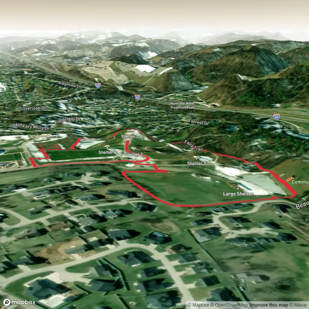
1.9 km
~23 min
6 m
Loop
“A gentle, mostly level nature wander where birdsong, wildflowers, and mossy nooks steal the show.”
A short, mostly level wander of about 2 km (1.2 mi) with essentially 0 m (0 ft) of climbing, this easy outing is best treated as a slow-paced nature stroll—ideal for families, casual walkers, and anyone wanting a low-effort loop/out-and-back where the “highlights” are small details: birdsong, wildflowers, mossy corners, and little viewpoint moments rather than big elevation payoffs.
Because your hike details are missing the start location (the “near …” field is blank) and there are no coordinates provided, I can’t reliably convert a lon/lat to a nearby address/landmark or give accurate public-transport directions to the trailhead yet. If you paste either:
- a Google Maps pin, or
- the trailhead coordinates (lat, lon), or
- the town/park/region + country/state,
…I’ll lock the description to the correct place, including the nearest recognizable address/landmark and the best access options.
What the walk is like (distance, surface, and pacing)
Plan on 30–60 minutes of walking time for 2 km (1.2 mi) depending on stops. With negligible elevation change, the effort comes more from surface conditions than fitness: - Firm paths / boardwalk / compact gravel: comfortable in trainers. - Forest duff, sand, or leaf litter: can feel uneven despite being flat. - After rain: puddling and slick roots can be the main hazard on an otherwise easy route.
If you’re walking with kids or anyone unsteady on their feet, the most common “easy-trail” trip hazards are roots, low steps, and edge drop-offs beside ditches/streams—small features that don’t show up in elevation stats.
Navigation and staying on track
Even on a short trail, it’s worth having the route loaded in HiiKER so you can confirm junctions quickly—especially if the Fairy Trail shares corridors with other short paths (common in parks and nature reserves). Watch for: - Unsigned spur paths to benches, viewpoints, or water access - Multiple parallel tracks (people-made “desire lines”) that can pull you off the intended route - Short connector trails that can accidentally turn a 2 km (1.2 mi) stroll into a longer wander
Landmarks and what to look for
Without the exact location, I can’t name the specific features on your Fairy Trail, but on trails with this name the “fairy” theme is often tied to one or more of the following—use these as a checklist once you share the trailhead and I’ll tailor it precisely:
- Creekside sections: listen for running water and look for shaded, ferny banks. These areas can be cooler and damper, with more moss and fungi.
- Old-growth or “storybook” trees: gnarled trunks, hollows, and buttressed roots are often the signature photo spots.
- Small bridges/boardwalks: common where the trail crosses wet ground; these can be slick with algae in humid seasons.
- Interpretive signs / themed markers: some Fairy Trails include carved posts, story plaques, or kid-focused nature prompts.
Nature and wildlife (seasonal expectations)
On a flat, short trail, wildlife encounters are usually quiet and close-range rather than dramatic. What you’ll most often notice: - Birdlife: small songbirds in shrubs and canopy edges; early morning is best. - Pollinators: butterflies and bees around sunny clearings and flowering edges. - Amphibians (where there’s water): frogs/newts near damp ground—watch your step and avoid handling them. - Deer/foxes/rabbits (in many regions): typically seen at dawn/dusk or as tracks/scat.
Practical cautions that apply almost everywhere: - Ticks in long grass and leaf litter—wear long socks, do a check afterward. - Stinging insects near flowering patches—move calmly, especially if you’re carrying sweet drinks. - Poison ivy/oak/nettle depending on region—stay centered on the tread.
Hazards to plan for (even on an “easy” 2 km)
“Easy” doesn’t mean risk-free. The most common issues on short, flat trails: - Slippery surfaces: wet roots, polished rock, algae on boardwalks. - Mud: can be surprisingly deep in low-lying sections; consider shoes you don’t mind dirty. - Crowds: narrow paths can mean frequent passing—keep an eye out for runners and small kids darting around. - Short daylight complacency: people skip water/layers; bring at least a small bottle and a light shell if weather is changeable.
What to bring (light but prepared)
For a 2 km (1.2 mi) easy walk: - Water: ~250–500 ml per person (more in heat). - Footwear: comfortable walking shoes; choose treadier soles if it’s wet. - Layers: a light wind/rain layer if conditions are uncertain. - Bug/tick protection: repellent as needed; consider long pants in brushy areas. - HiiKER route downloaded offline if cell coverage is spotty.
Getting to the start (car + public transport)
I can’t give accurate directions without the trailhead location/coordinates, but here’s exactly what I’ll provide once you share them: - Nearest known address or landmark to the trailhead (converted from lon/lat if you send coordinates

Comments and Reviews
User comments, reviews and discussions about the Fairy Trail, West Virginia.
average rating out of 5
0 rating(s)