Download
Preview
Add to list
More
4.2 km
~1 hrs
105 m
Out and Back
“Wander a quiet North Georgia forest path to a humble family cemetery, watching your footing.”
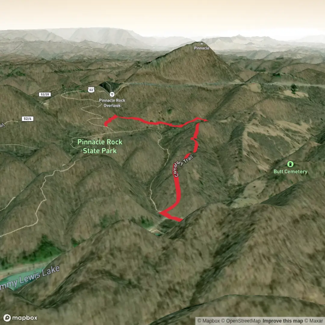
This is a short, steady forest walk to a small, rural family cemetery in the North Georgia mountains—about 4 km / 2.5 mi round trip with roughly 100 m / 330 ft of total climbing. Expect a “medium” feel mostly because the tread can be uneven and the route may be lightly signed in places, not because it’s especially long or steep.
Where the hike is (and what to put in your GPS)
“Butt Cemetery” is mapped in Union County, Georgia at approximately 34.8579, -83.9707. That coordinate sits in the mountains north of Blairsville and is closest to the Coosa Bald area (Chattahoochee National Forest region). For navigation, load the route on HiiKER before you go and download it for offline use—cell service can be patchy in these folds of terrain.
Because this is a small backcountry cemetery rather than a developed park facility, the “nearest known address” is often not a street number but a named place. The most useful landmark to orient yourself is Blairsville, GA, with the cemetery being in the mountainous backcountry to the north/northeast of town.
Getting to the trailhead (car + public transport reality check)
By car: Plan on driving from Blairsville, GA into the surrounding mountain roads. Roads in this area can be narrow, winding, and occasionally gravel; after rain, potholes and washboarding are common. Park only where you’re fully off the roadway and not blocking gates or driveways—many small cemeteries sit near private land boundaries.
By public transport: There typically isn’t practical public transit to remote trailheads in Union County’s mountain backroads. The most workable approach is to get to Blairsville (or another nearby town) via regional transport and then use a rideshare/taxi—though availability can be limited. If you’re relying on a pickup, set expectations: you may need to schedule in advance and share your exact pin from HiiKER.
What the hike feels like underfoot
With ~100 m / 330 ft of gain over ~4 km / 2.5 mi, the climbing is moderate and usually comes in gentle-to-moderate pitches rather than one long grind. You’ll likely move through mixed North Georgia woodland—hardwoods with seasonal understory changes:
- Spring–summer: dense green growth, more ticks/gnats, and wetter tread in shaded hollows
- Fall: leaf cover can hide rocks/roots and make the trail slick on descents
- Winter: clearer sightlines through the woods, but colder, damper footing and occasional ice in shaded spots
Even on a short route, plan for mud after rain, and expect roots, embedded rocks, and small drainage dips that can slow your pace.
Landmarks and points of interest
The main landmark is the cemetery itself—typically a small, fenced or partially defined plot with older headstones. In this part of Appalachia, family cemeteries often reflect settlement patterns from the 1800s into the early 1900s, when homesteads were spread along ridges and hollows and burial grounds were kept close to family land. If you see very old stones, they can be fragile—avoid touching or cleaning them.
Other “quiet landmarks” to watch for on the approach: - Old roadbeds or benched trail sections that hint at historic access routes - Stone piles or low rock lines that can mark former property boundaries - Mature hardwood stands on slopes and slightly more open, brushy growth in disturbed areas
Nature and wildlife to look out for
This is classic North Georgia mountain habitat. Common sightings (or signs) include: - White-tailed deer (often at dawn/dusk) - Wild turkey and songbirds in the canopy - Black bear presence is possible—more often you’ll notice scat or turned-over logs than the animal itself - Snakes in warm months (watch sunny edges and rockier patches)
Practical cautions: - Ticks are a big one here—use repellent, wear long socks, and do a full check afterward. - Poison ivy can line narrow sections; learn the leaf pattern and avoid brushing vegetation. - After storms, expect downed limbs and occasional blowdowns that force short detours.
Planning

Surfaces
Ground
Paved
Unknown
Comments and Reviews
User comments, reviews and discussions about the Butt Cemetery Trail, West Virginia.
average rating out of 5
0 rating(s)