Mary Draper Ingles Trail, Hemlock Falls Trail and Davis Creek Trail
Download
3D Flyover
Add to list
More
13.4 km
~3 hrs 8 min
280 m
Point-to-Point
“Climb a quiet hardwood ridge, slip down to a shaded waterfall, and wander back through muddy hollows.”
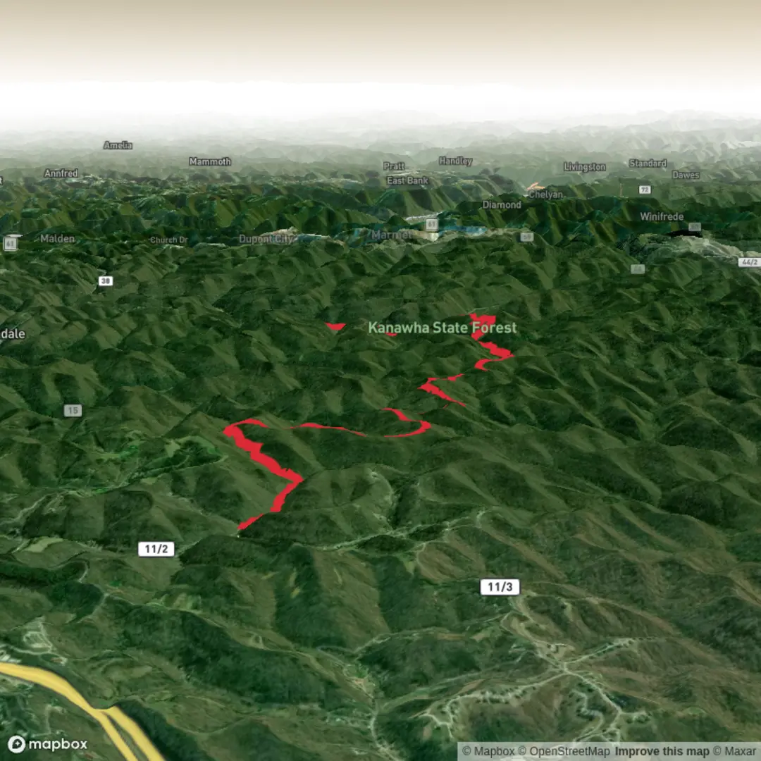
This ~13 km (8.1 mi) medium loop with about ~300 m (985 ft) of climbing is a classic Kanawha State Forest sampler: a steady ridge climb on the Mary Draper Ingles Trail, a shaded descent toward a waterfall on Hemlock Falls Trail, then a longer, quieter return on Davis Creek Trail through mixed Appalachian hardwood forest. Expect a mix of old roadbed, narrower singletrack, and a few wet/muddy stretches—especially anywhere the route follows former gas-well or access roads.
Nearest known start point / landmark: the Mary Ingles Trailhead on McGhee Road inside Kanawha State Forest, near the forest’s main developed area around 7500 Kanawha State Forest Dr, Charleston, WV 25314. (wvstateparks.com)
Getting to the trailhead (car + public transport)
- By car: Navigate to Kanawha State Forest, 7500 Kanawha State Forest Dr, Charleston, WV 25314, then follow internal forest roads toward McGhee Road for the Mary Ingles Trailhead. Cell service can be inconsistent in the hollows, so it helps to load the route in HiiKER before you drop into the forest. (wvstateparks.com)
- By public transport: There isn’t a reliable “to-the-trailhead” transit stop inside the forest. The practical approach is to take transit into Charleston and then use a rideshare/taxi to the forest entrance at 7500 Kanawha State Forest Dr; from there it’s still a short drive to McGhee Road. (If you’re trying to do this fully car-free, plan extra time and confirm rides in advance.)
You’ll want standard “medium hike” kit: shoes with good wet traction, a light rain layer, and at least 1–1.5 L of water (more in summer humidity). Trekking poles help on the steeper, slicker pitches and on any streamside tread.
What the hike feels like, section by section
0.0–~1.1 km (0.0–0.7 mi): Mary Draper Ingles Trail—easy warm-up on old roadbed
From the McGhee Road Trailhead, the Mary Draper Ingles Trail begins along an old road for about 0.7 mi (1.1 km). This opening is a good place to settle into pace and do a quick gear check. You’ll cross small drainages/streamlets repeatedly early on—these can be rock-hoppable in dry weather but may require careful foot placement after rain. (wvscenictrails.org)
~1.1–~5.5 km (0.7–3.4 mi): Climb toward Boundary Ridge—steady gain, forested and quiet
After the early crossings, the route transitions into more “woods trail” character and starts working uphill more consistently. Over this middle portion you’ll accumulate most of the day’s elevation gain (aiming toward that ~300 m / 985 ft total). The climb is rarely brutal, but it’s sustained—expect to feel it in the last third as the grade tightens in places approaching the ridge road network.
Forest character here is classic central Appalachian: mixed hardwoods with a dense understory in leaf-out, and a lot of seasonal wildflowers in spring. Wildlife is typically subtle rather than dramatic—songbirds, squirrels, and the occasional white-tailed deer. In warmer months, tick checks are a must after brushing past trail-edge vegetation.
Navigation note: Kanawha State Forest has a dense trail system and multiple road/trail junctions; keep your next turn queued up in HiiKER so you don’t drift onto a parallel ridge road or connector.
Hemlock Falls segment: the waterfall drop and the “wet road” tread
~5.5–~7.5 km (3.4–4.7 mi): Hemlock Falls Trail—descending toward Polly Hollow
Hemlock Falls Trail is a shorter connector in the forest’s official system (listed at 0.75 mi / 1.2 km), and it’s commonly described as following a remote gas-well road out of Polly Hollow up toward Boundary Ridge Road. In practice, that means the tread can hold water and stay muddy even when other trails dry out. (wvstateparks.com

Surfaces
Unknown
Unpaved
Ground
Comments and Reviews
User comments, reviews and discussions about the Mary Draper Ingles Trail, Hemlock Falls Trail and Davis Creek Trail, West Virginia.
average rating out of 5
0 rating(s)