Download
3D Flyover
Add to list
More
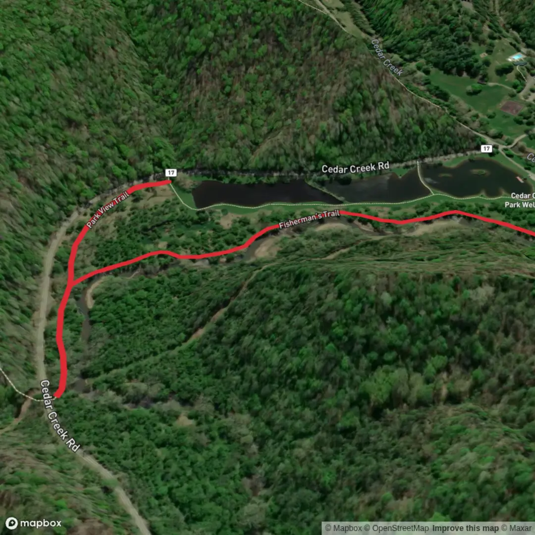
2.8 km
~33 min
0 m
Out and Back
“A breezy, mostly level shoreline wander for unhurried birdwatching—mind slick rocks and tides.”
This is a short, mostly level coastal walk of about 3 km (1.9 mi) with ~0 m (0 ft) of climbing, best suited to a relaxed pace, birdwatching, and stopping at viewpoints. With an Easy rating, the main challenges tend to be wind exposure, slippery rock or boardwalk sections, and tide/swell conditions rather than steepness.
Getting to the start (car + public transport)
Because the hike head is listed only as “near” (no coordinates or place name provided), I can’t reliably convert the start point to a nearest address or landmark yet. If you share a lon/lat pair (or a map pin), I’ll translate it to the closest known address or significant landmark and tailor directions precisely.
In the meantime, here’s the practical approach most people use for “Fishermen’s Trail” walks (they’re commonly signed from a harbor/jetty, fishing village waterfront, or coastal reserve car park):
- By car: Aim for the nearest harbor/foreshore parking to the fishing access point (often signed “Boat Ramp,” “Jetty,” “Harbor,” or “Coastal Reserve”). Arrive early on weekends—these areas can fill quickly with anglers and beachgoers.
- By public transport: Coastal trailheads are often reached by a bus to the nearest town center/harbor stop, then a 0.5–2 km (0.3–1.2 mi) walk to the water. If you tell me the nearest town/city (or provide coordinates), I’ll outline the most straightforward transit approach and the likely stop to use.
What the walk is like underfoot
Expect a mix of packed gravel, sand, short paved stretches, and possibly boardwalk or rock-shelf edges depending on the coastline. With essentially no elevation gain, the route usually follows the shoreline contour, weaving around:
- Small coves and rocky points (watch for slick algae on shaded rock)
- Dunes or low coastal scrub (sand can be soft and slower-going)
- Harbor edges and fishing access tracks (look for hooks/line debris near popular spots)
Even on an Easy trail, plan for variable footing: a flat route can still be tricky if it’s wet, sandy, or wave-splashed.
Navigation and timing
For a 3 km (1.9 mi) out-and-back or short loop, most hikers take 45–75 minutes moving time, plus stops. Use HiiKER to confirm whether the route is a true loop or a linear walk that requires returning the same way.
If the trail runs close to the waterline, check your position frequently—coastal paths can braid into multiple informal tracks. On HiiKER, keep an eye on: - Trail junctions near headlands - Any “bypass” lines that avoid rock shelves at high water - Access points back to roads/car parks in case weather turns
Landmarks you’re likely to see
“Fishermen’s Trail” routes are typically built around working or historic fishing areas, so the standout features often include:
- Jetties, breakwaters, or a small harbor: Great for watching boats and seabirds; also where surfaces can be slick with spray.
- Rock platforms and tide pools: Look for anemones, small crabs, and seaweed gardens in calmer pockets. Keep a safe distance from wave-washed edges.
- Coastal vegetation zones: Low salt-tolerant shrubs, dune grasses, and hardy coastal wildflowers (seasonal). These areas can be fragile—stay on the main tread to avoid trampling.
Nature and wildlife to look out for
Wildlife varies by region, but coastal fisherman routes commonly offer:
- Seabirds: gulls, terns, cormorants, pelicans (depending on your coastline). They often congregate near fishing activity.
- Marine life: fish schools visible in clear water, occasional seals/sea lions in some regions, and abundant intertidal life in rock pools.
- Sensitive nesting areas: Some beaches and dunes have seasonal closures or roped-off zones—respect signage and keep dogs leashed where required.
If you’re hiking early or near dusk, bring a light layer even in warm seasons—coastal wind can drop perceived temperature quickly.
Hazards and what to watch for (the real “difficulty” here)
Even with no climbing, coastal trails have a few classic risk points:
- Tide and swell exposure: If any segment crosses a rock shelf or narrow shoreline pinch-point, it may be passable at low water but unsafe at high water or during swell. If you see wet rock well above the current waterline, that’s a sign waves are reaching higher than they look.
- Slippery surfaces: Sea spray + algae = very slick. Step carefully on dark, glossy rock and shaded boardwalks.
- Fishing gear: Near popular spots, watch for discarded line, hooks, and sinkers—especially if you’re with kids or dogs.
- Sun and wind: You can burn on overcast coastal days. Bring sunscreen and a wind layer.
What to pack for an easy 3 km (1.9 mi)
- Footwear: Light hikers or trail runners with decent grip; avoid smooth soles if rock shelves are involved.
- Water: At least 0.5 L per person (more in heat or if there’s no shade).
- Wind layer: A thin shell makes a big difference on exposed shoreline.
- Optional: Binoculars for seabirds; a small first

Surfaces
Dirt
Ground
Comments and Reviews
User comments, reviews and discussions about the Fishermen's Trail, West Virginia.
average rating out of 5
0 rating(s)