Download
3D Flyover
Add to list
More
6.0 km
~1 hrs 12 min
6 m
Point-to-Point
“Stroll the riverside floodwall for big-sky views, breezy birdsong, and a simple out-and-back escape.”
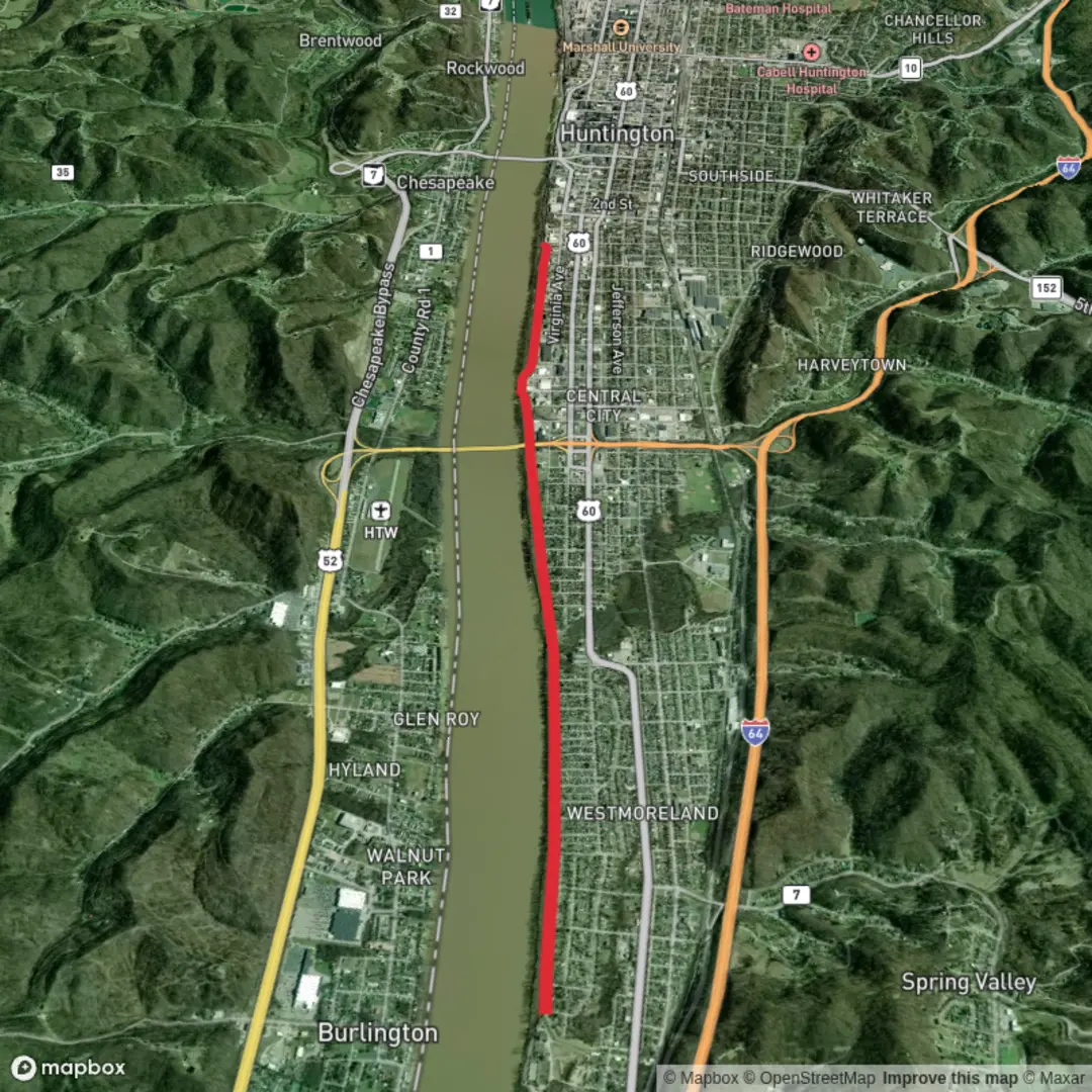
This is a flat, riverside out-and-back style walk of about 6 km (3.7 miles) with essentially 0 m (0 ft) of climbing, following the top of a flood-control levee (“floodwall”) and adjacent paved paths. It’s ideal for an easy fitness walk, a relaxed family stroll, or a quick leg-stretcher when you want open views and straightforward navigation.
Getting to the start (car + public transport)
Because the start point is listed only as “near” (no coordinates provided), the most reliable way to pin down the exact trailhead is to open the route in HiiKER and use the start marker to identify the closest access point and parking. In most towns with a named “Huntington Floodwall Trail,” the easiest access is typically from a riverfront park, floodwall gate, or a trail access ramp near downtown/riverfront streets.
By car - Aim for riverfront parking near the floodwall/levee access—often signed as a riverfront park, boat ramp, or “floodwall” access. - Expect paved lots and street parking options. On weekends or during events, riverfront parking can fill quickly.
By public transport - If the trail is in/near a downtown riverfront area (common for floodwall paths), local buses often stop within a few blocks of the riverfront. Use HiiKER to identify the nearest cross street/park name, then match that to your local transit app’s closest stop. - Plan for a short 0.3–1.0 km (0.2–0.6 mile) walk from a central stop to the levee access ramp.
If you share the lon/lat for the start (or a HiiKER link), I can convert it to the nearest known address or landmark precisely.
What the walk is like underfoot
Most floodwall/levee trails are paved asphalt or smooth concrete on top, sometimes with short connectors of packed gravel. With negligible elevation change, the effort comes mainly from distance, sun exposure, and wind rather than hills.
- 0.0–1.0 km (0.0–0.6 mi): You’ll usually begin near an access ramp or gate where the path climbs gently up onto the levee crown (still effectively flat overall). Expect wide, open sightlines and a “straight-ahead” feel.
- 1.0–3.0 km (0.6–1.9 mi): The most scenic stretch tends to be here—long river views, bridges in the distance, and occasional overlooks where you can watch barge traffic (where applicable). This is also where wind can be strongest.
- 3.0 km (1.9 mi) turnaround: Many hikers turn around at a convenient landmark—an underpass, a park boundary, a bridge approach, or a floodwall feature—then retrace the same route back to the start for the full 6 km (3.7 mi).
Because the route is flat and often straight, it’s easy to underestimate sun and wind. Even on mild days, the exposed levee top can feel hotter (no shade) or colder (windchill).
Landmarks and points of interest
Floodwall trails are built around infrastructure, so the “landmarks” are often a mix of civic features and river scenery:
- Floodwall/levee structures: Look for floodgates, pump stations, and closure points where roads pass through the wall. These are interesting engineering features and can be good navigation anchors.
- Riverfront parks and boat ramps: Common along these corridors; they’re useful for rest stops and often have benches or picnic areas.
- Bridges and rail corridors: Many river towns have prominent bridge crossings and rail lines near the water—great for photos, but be mindful of noise and occasional vibration if you’re near active tracks.
- Interpretive signage (sometimes): Some floodwall systems include plaques about historic floods, river commerce, or local history.
Nature and wildlife you’re likely to see
Even in an urban setting, river edges concentrate wildlife.
- Birdlife: Expect gulls/terns, herons/egrets, ducks and geese, and seasonal migrants. Early morning is best for activity.
- River mammals: Depending on region, you may spot muskrat, beaver, or river otter signs (tracks, slides, chewed vegetation), though sightings are less common in busy areas.
- Plants: Levee slopes often have grasses and hardy shrubs; near the water you may see willows, cottonwoods, and other riparian vegetation. In late spring/summer, some sections can be thick with growth and insects.
Hazards and what to look out for
Even “easy” floodwall walks have a few consistent watch-outs:
- Exposure: Little shade on top of the levee. Bring water—especially in warm weather—and consider a hat/sunscreen.
- Wind: Strong gusts are common along open river corridors; secure hats and be cautious near edges.
- Surface conditions: After rain, connectors can be slick with silt; in winter, shaded underpasses can hold ice longer than expected.
- Cyclists and runners: These paths are often multi-use. Keep right, listen for passing traffic, and manage dogs on a short leash.
- Flood operations: During high water, some access points may be closed or busy with maintenance. Respect barriers and signage—flood infrastructure can change quickly with river conditions.
- Insects: Mosquitoes and gnats can be intense near

Surfaces
Unknown
Concrete
Gravel
Asphalt
Comments and Reviews
User comments, reviews and discussions about the Huntington Floodwall Trail, West Virginia.
average rating out of 5
0 rating(s)