Download
3D Flyover
Add to list
More
4.3 km
~51 min
0 m
Out and Back
“A gentle, mostly level riverside stroll where two storied rivers meet, echoing rail-and-coal history.”
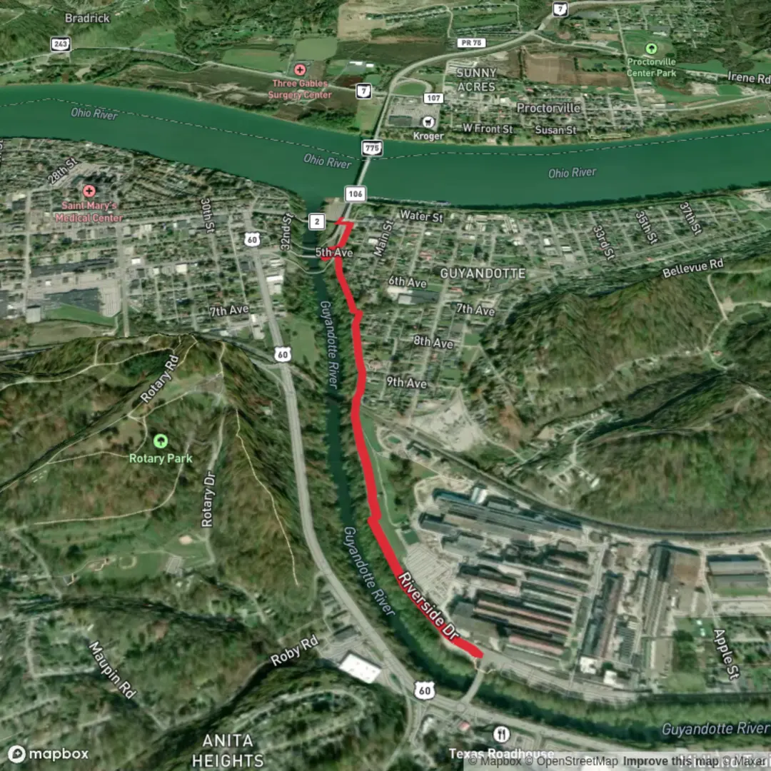
This is a short, low-effort riverside walk (about 4 km / 2.5 mi) with essentially flat elevation change (≈0 m / 0 ft gain), best treated as an easy out-and-back or a simple point-to-point if you’ve arranged a pickup. You’ll be walking in the Guyandotte area of Huntington, West Virginia, where the Guyandotte River meets the Ohio River—a landscape shaped by river commerce, rail history, and the broader coalfield story of southern West Virginia. (en.wikipedia.org)
Getting to the start (car + public transport)
Because “Guyandotte Trail” is used locally for a few closely related riverside path segments, it’s smart to confirm the exact access point in HiiKER before you leave (and download the route for offline use if cell service is spotty near the river bends).
- By car: The most straightforward “known landmark” access in the Guyandotte neighborhood is the Guyandotte Boat Ramp area (Huntington, WV 25702), which is commonly used as a riverside access point and a practical place to begin a flat walk along the water. (visithuntingtonwv.org)
- By public transport: Huntington’s bus coverage varies by neighborhood and time of day; the most reliable approach is usually to ride into the Guyandotte neighborhood and walk the last few blocks to the river access. If you’re planning a transit start, check the nearest stop to your chosen HiiKER start pin and build in extra time for less frequent service.
What the walk feels like underfoot
Expect a level, easy-grade path suitable for beginners and casual walkers. Surfaces on Huntington-area multi-use paths are often a mix of paved and compacted gravel depending on the segment and maintenance cycle; after rain, low spots near the river can hold water or stay soft longer than you’d expect on a flat route.
Because the elevation gain is negligible, the main “effort” factors are: - Sun and heat exposure (river corridors can feel hotter and more humid in summer) - Wind off the water (noticeable in cooler months) - Occasional muddy patches after high water or storms
Landmarks, scenery, and nature to watch for
You’ll spend much of the hike with the Guyandotte River nearby, in a classic Appalachian river-valley setting where wooded slopes and developed edges meet. The Guyandotte is a major river system in southwestern West Virginia (about 166 mi / 267 km long), and its lower reaches near Huntington reflect both natural river dynamics and a long history of human use. (en.wikipedia.org)
Wildlife and plants (typical for this corridor): - Songbirds and water-associated birds (look for activity along quieter banks and backwaters) - Turtles sunning on logs in warm months - Deer at dawn/dusk near brushy edges - In buggy seasons, expect mosquitoes and gnats—especially in still, humid conditions near the water
If you’re walking close to the bank, keep an eye out for poison ivy along the edge vegetation and any undercut banks where the ground can crumble.
Safety and “what to look out for”
Even on an easy, flat 4 km (2.5 mi) outing, river-adjacent trails have a few consistent hazards:
- High water / slick edges: After heavy rain upstream, the Guyandotte can rise and leave slick silt on adjacent surfaces. Give the bank a wide berth.
- Shared-use traffic: These riverside paths can attract walkers, runners, and cyclists. Stay predictable, keep right, and listen for bikes approaching from behind.
- Heat management: With minimal shade in some stretches, bring water even for a short walk—especially in late spring through early fall.
Historical context (why this area matters)
You’re walking in and around Guyandotte, a historic community that predates its incorporation into Huntington and has long been tied to Ohio River and regional trade routes. The rivers here weren’t just scenery—they were transportation corridors that shaped settlement patterns, industry, and the growth of Huntington as a rail-and-river city. (en.wikipedia.org)
More broadly, the Guyandotte River corridor is closely associated with

Surfaces
Unknown
Concrete
Asphalt
Comments and Reviews
User comments, reviews and discussions about the Guyandotte Trail, West Virginia.
average rating out of 5
0 rating(s)