Download
Preview
Add to list
More
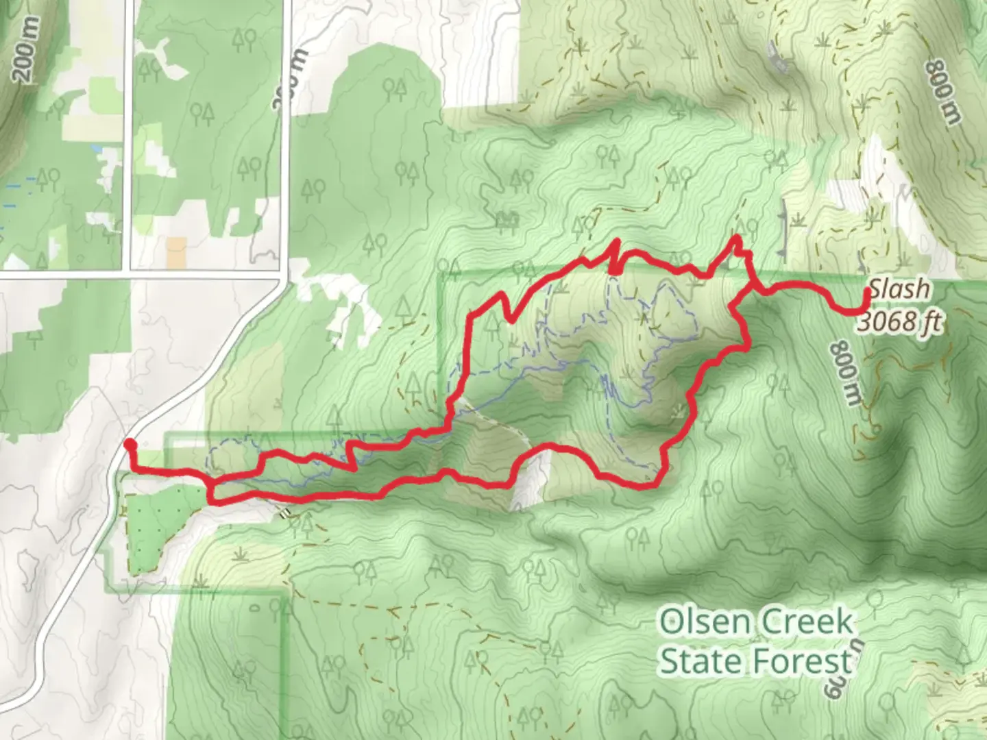
11.5 km
~3 hrs 41 min
829 m
Loop
“Embark on the Y Road Loop Trail for a 12 km journey through lush forests, stunning viewpoints, and historical landmarks.”
Starting your adventure near Whatcom County, Washington, the Y Road Loop Trail offers a captivating 12 km (7.5 miles) journey with an elevation gain of approximately 800 meters (2,625 feet). This loop trail is rated as medium difficulty, making it suitable for hikers with some experience and a good level of fitness.
Getting There
To reach the trailhead, you can drive or use public transportation. If driving, head towards Whatcom County and look for parking near the intersection of Y Road and Lake Louise Road. For those using public transport, the nearest significant landmark is the Bellingham Station. From there, you can take a local bus or taxi to the trailhead.
Trail Overview
The Y Road Loop Trail begins with a gentle ascent through lush forested areas, where you'll be surrounded by towering Douglas firs and Western red cedars. The initial 2 km (1.2 miles) are relatively easy, allowing you to warm up and enjoy the serene environment.
Key Landmarks and Points of Interest
As you progress, the trail becomes steeper, gaining elevation more rapidly. Around the 4 km (2.5 miles) mark, you'll encounter a beautiful viewpoint overlooking Lake Whatcom. This is an excellent spot to take a break and soak in the panoramic views.
Continuing on, the trail meanders through diverse ecosystems, including sections of dense forest and open meadows. Keep an eye out for local wildlife such as black-tailed deer, various bird species, and occasionally, black bears. It's advisable to carry bear spray and make noise to avoid surprising any wildlife.
Historical Significance
The region around Whatcom County has a rich history, with indigenous tribes such as the Lummi and Nooksack having inhabited the area for thousands of years. The trail itself passes through lands that were historically used for logging in the early 20th century. Remnants of old logging equipment and rail tracks can still be seen in some parts of the trail, offering a glimpse into the area's industrial past.
Navigation and Safety
Given the trail's moderate difficulty and varying terrain, it's crucial to have a reliable navigation tool. HiiKER is highly recommended for its detailed maps and real-time updates. The trail is well-marked, but having a digital map can help you stay on course, especially in areas where the path may be less defined.
Final Stretch
The final 3 km (1.9 miles) of the trail involve a descent back towards the trailhead. This section can be quite steep and rocky, so take your time and watch your footing. As you near the end, you'll pass through a picturesque grove of maple trees, which is particularly stunning in the fall when the leaves change color.
Preparation Tips
Ensure you bring plenty of water, snacks, and a first-aid kit. Weather in this region can be unpredictable, so dress in layers and be prepared for rain. Good hiking boots with ankle support are essential due to the varied terrain and elevation changes.
By following these guidelines and being well-prepared, you'll have a rewarding and enjoyable experience on the Y Road Loop Trail.

What to expect?
Activity types
Comments and Reviews
User comments, reviews and discussions about the Y Road Loop Trail, Washington.
4.42
average rating out of 5
12 rating(s)