Download
Preview
Add to list
More
2.9 km
~58 min
240 m
Out and Back
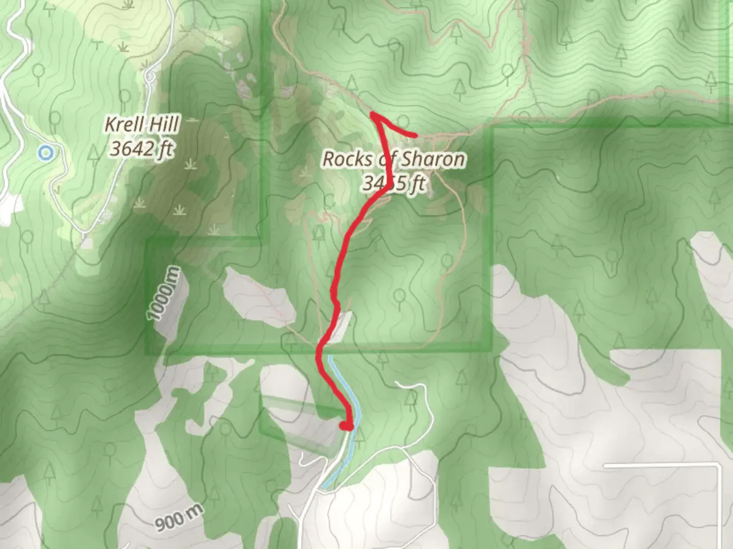
“The Rocks of Sharon Viewpoint Trail offers a moderately challenging 3-kilometer hike with stunning Spokane Valley views.”
Starting near Spokane County, Washington, the Rocks of Sharon Viewpoint Trail is an invigorating out-and-back hike that spans approximately 3 kilometers (1.86 miles) with an elevation gain of around 200 meters (656 feet). This trail is rated as medium difficulty, making it suitable for moderately experienced hikers.
Getting There
To reach the trailhead, you can drive or use public transport. If driving, head towards the Iller Creek Conservation Area, which is the nearest significant landmark. The trailhead is located near the intersection of Holman and Stevens Creek Roads. For those using public transport, the Spokane Transit Authority (STA) offers bus services that can get you relatively close to the trailhead, but you may need to arrange for a taxi or rideshare for the final leg of the journey.
Trail Navigation
For navigation, it's highly recommended to use HiiKER, which provides detailed maps and real-time updates. The trail is well-marked, but having a reliable navigation tool can enhance your hiking experience.
Trail Description
The trail begins with a gentle ascent through a mixed forest of pine and fir trees. After about 0.5 kilometers (0.31 miles), you'll start to notice the terrain becoming rockier. Keep an eye out for the diverse flora, including wildflowers in the spring and summer months. The first significant landmark you'll encounter is a small creek, which you will cross via a wooden bridge.
Wildlife and Nature
As you continue, the trail opens up to a more rugged landscape. This area is home to various wildlife, including deer, squirrels, and a variety of bird species. If you're lucky, you might even spot a hawk or an eagle soaring above. The trail is also known for its beautiful wildflowers, especially in the spring and early summer.
Historical Significance
The region has a rich history, with the Rocks of Sharon being a notable geological formation. These rocks were named after a local legend, Sharon, who was said to have discovered the area in the early 1900s. The rocks themselves are ancient, formed millions of years ago, and offer a glimpse into the geological history of the region.
Reaching the Viewpoint
After about 1.5 kilometers (0.93 miles) and an elevation gain of approximately 100 meters (328 feet), you'll reach a fork in the trail. Take the right path to continue towards the viewpoint. The final stretch is a bit steeper, so take your time and enjoy the surrounding scenery.
The Viewpoint
Upon reaching the Rocks of Sharon Viewpoint, you'll be rewarded with panoramic views of the Spokane Valley and the surrounding mountains. This is a perfect spot to take a break, have a snack, and soak in the natural beauty. The viewpoint is also an excellent location for photography, so don't forget your camera.
Return Journey
The return journey follows the same path back to the trailhead. As it's an out-and-back trail, you'll have the opportunity to enjoy the scenery from a different perspective on your way down.
Final Tips
Make sure to bring plenty of water, especially during the warmer months, and wear sturdy hiking boots as the rocky sections can be challenging. Always check the weather forecast before heading out and let someone know your hiking plans.

What to expect?
Activity types
Comments and Reviews
User comments, reviews and discussions about the Rocks of Sharon Viewpoint Trail, Washington.
4.42
average rating out of 5
12 rating(s)