Download
3D Flyover
Add to list
More
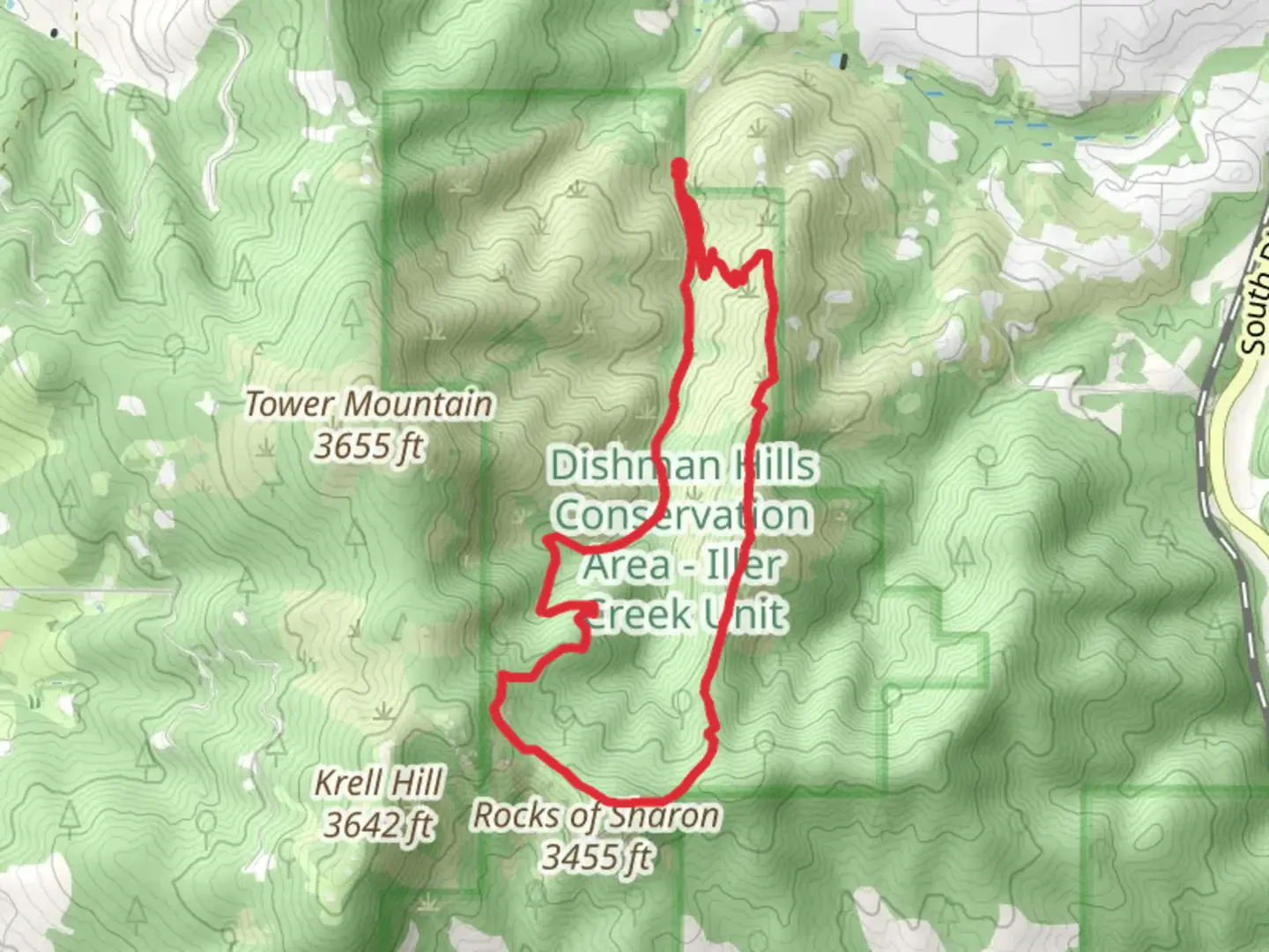
8.1 km
~2 hrs 18 min
419 m
Loop
“Embark on the Iller Creek Loop for lush forests, panoramic views, and moderate hiking challenges.”
Starting your adventure near Spokane County, Washington, the Iller Creek Loop is an 8 km (5 miles) trail with an elevation gain of approximately 400 meters (1,312 feet). This loop trail is rated as medium difficulty, making it accessible for most hikers with a moderate level of fitness.
Getting There
To reach the trailhead, you can drive or use public transportation. If driving, head towards the Iller Creek Conservation Area, which is located near the intersection of Holman Road and Dishman-Mica Road. For those using public transport, the nearest bus stop is at the intersection of Dishman-Mica Road and Schafer Road. From there, it's a short walk to the trailhead.
Trail Overview
The Iller Creek Loop offers a diverse hiking experience, featuring lush forests, open meadows, and stunning rock formations. The trail is well-marked, but it's always a good idea to have a reliable navigation tool like HiiKER to ensure you stay on track.
Key Landmarks and Sections
The Ascent
Starting from the trailhead, the first section of the trail takes you through a dense forest of Ponderosa pines and Douglas firs. This initial ascent is gradual but steady, covering about 2 km (1.2 miles) with an elevation gain of around 150 meters (492 feet). Keep an eye out for deer and various bird species that inhabit this area.
The Rocks of Sharon
At approximately 3 km (1.8 miles) into the hike, you'll reach the iconic Rocks of Sharon. These massive granite formations offer panoramic views of the Spokane Valley and the Palouse. This is a great spot to take a break, enjoy a snack, and snap some photos. The elevation gain to this point is about 250 meters (820 feet).
The Ridge
Continuing along the ridge, the trail levels out for a while, providing a welcome respite from the climb. This section is about 1.5 km (0.9 miles) long and offers stunning views of the surrounding landscape. The ridge is also home to various wildflowers in the spring and summer months, adding a splash of color to your hike.
The Descent
The final section of the loop is a descent back into the forest. This part of the trail is about 3.5 km (2.2 miles) long and can be a bit steep in places, so watch your footing. The descent takes you through a mix of forest and open meadows, eventually leading you back to the trailhead.
Flora and Fauna
The Iller Creek Loop is rich in biodiversity. In addition to the Ponderosa pines and Douglas firs, you'll encounter a variety of shrubs, wildflowers, and possibly even some mushrooms, especially after a rain. Wildlife is abundant, with deer, squirrels, and a variety of birds commonly seen along the trail.
Historical Significance
The area around Iller Creek has a rich history, with evidence of Native American use dating back thousands of years. The Rocks of Sharon were named after a local homesteader and have been a popular spot for rock climbing and hiking for decades.
Final Tips
Make sure to bring plenty of water, especially during the summer months, as the trail can get quite hot. Wear sturdy hiking boots to navigate the rocky sections safely. Always check the weather forecast before heading out and be prepared for sudden changes in conditions. Using HiiKER can help you stay on track and provide additional information about the trail as you hike.

What to expect?
Activity types
Comments and Reviews
User comments, reviews and discussions about the Iller Creek Loop, Washington.
4.76
average rating out of 5
17 rating(s)