Download
Preview
Add to list
More
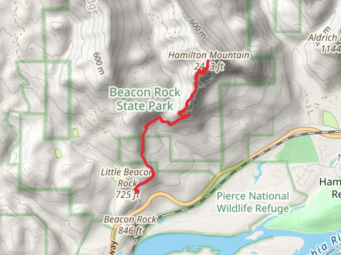
8.7 km
~3 hrs 13 min
891 m
Out and Back
“Experience the rewarding Hamilton Mountain Trail, with lush forests, stunning waterfalls, and breathtaking Columbia River Gorge views.”
Starting near Skamania County, Washington, the Hamilton Mountain Trail Out and Back offers a rewarding hike with a distance of approximately 9 km (5.6 miles) and an elevation gain of around 800 meters (2,625 feet). This medium-difficulty trail is perfect for those looking to experience the natural beauty and historical significance of the Columbia River Gorge.
Getting There
To reach the trailhead, you can drive to Beacon Rock State Park, located at 34841 State Route 14, Skamania, WA 98648. If you're using public transport, the nearest major city is Portland, Oregon. From Portland, you can take a bus to Cascade Locks and then a taxi or rideshare service to Beacon Rock State Park.
Trail Overview
The trail begins at the Beacon Rock State Park parking area. As you start your hike, you'll quickly find yourself immersed in lush forest, with Douglas firs and western red cedars towering above. The initial section of the trail is relatively gentle, allowing you to warm up before the more strenuous parts.
Significant Landmarks
- Rodney Falls (1.6 km / 1 mile in): About 1.6 km (1 mile) into the hike, you'll encounter Rodney Falls, a beautiful cascading waterfall. This is a great spot to take a short break and enjoy the scenery. The falls are particularly impressive in the spring when the water flow is at its peak.
- Pool of the Winds (1.8 km / 1.1 miles in): Just a bit further up the trail, you'll find the Pool of the Winds, a small but powerful waterfall that creates a swirling pool at its base. The mist from the falls can be refreshing on a hot day.
- Little Hamilton Mountain (3.2 km / 2 miles in): As you continue, you'll reach a junction where you can take a short detour to Little Hamilton Mountain. This side trail offers panoramic views of the Columbia River Gorge and is well worth the extra effort.
Wildlife and Flora
The Hamilton Mountain Trail is home to a variety of wildlife, including black-tailed deer, black bears, and numerous bird species such as the northern spotted owl and the pileated woodpecker. The flora is equally diverse, with wildflowers like trillium and lupine blooming in the spring and summer months.
Historical Significance
The Columbia River Gorge has a rich history, with evidence of human habitation dating back over 13,000 years. The area was historically inhabited by Native American tribes, including the Chinook and Klickitat. Beacon Rock, near the trailhead, was named by Lewis and Clark during their expedition in 1805 and is one of the most prominent landmarks in the region.
Navigation and Safety
Given the elevation gain and the sometimes steep and rocky sections of the trail, it's essential to be prepared. Make sure to bring plenty of water, wear sturdy hiking boots, and consider using trekking poles for added stability. The trail is well-marked, but it's always a good idea to have a reliable navigation tool like HiiKER to ensure you stay on track.
Final Ascent
The final push to the summit of Hamilton Mountain is the most challenging part of the hike, with steep switchbacks and rocky terrain. However, the effort is rewarded with breathtaking views from the top, where you can see the Columbia River, Mount Hood, and the surrounding landscape.
By planning accordingly and being prepared for the trail's challenges, you can fully enjoy the natural beauty and historical richness of the Hamilton Mountain Trail Out and Back.

What to expect?
Activity types
Comments and Reviews
User comments, reviews and discussions about the Hamilton Mountain Trail Out and Back, Washington.
4.5
average rating out of 5
10 rating(s)