Download
3D Preview
Add to list
More
21.6 km
~6 hrs 57 min
1583 m
Point-to-Point
“The Dog Mountain and Augspurger Mountain Trail offers challenging climbs, stunning Columbia River Gorge views, and rich history.”
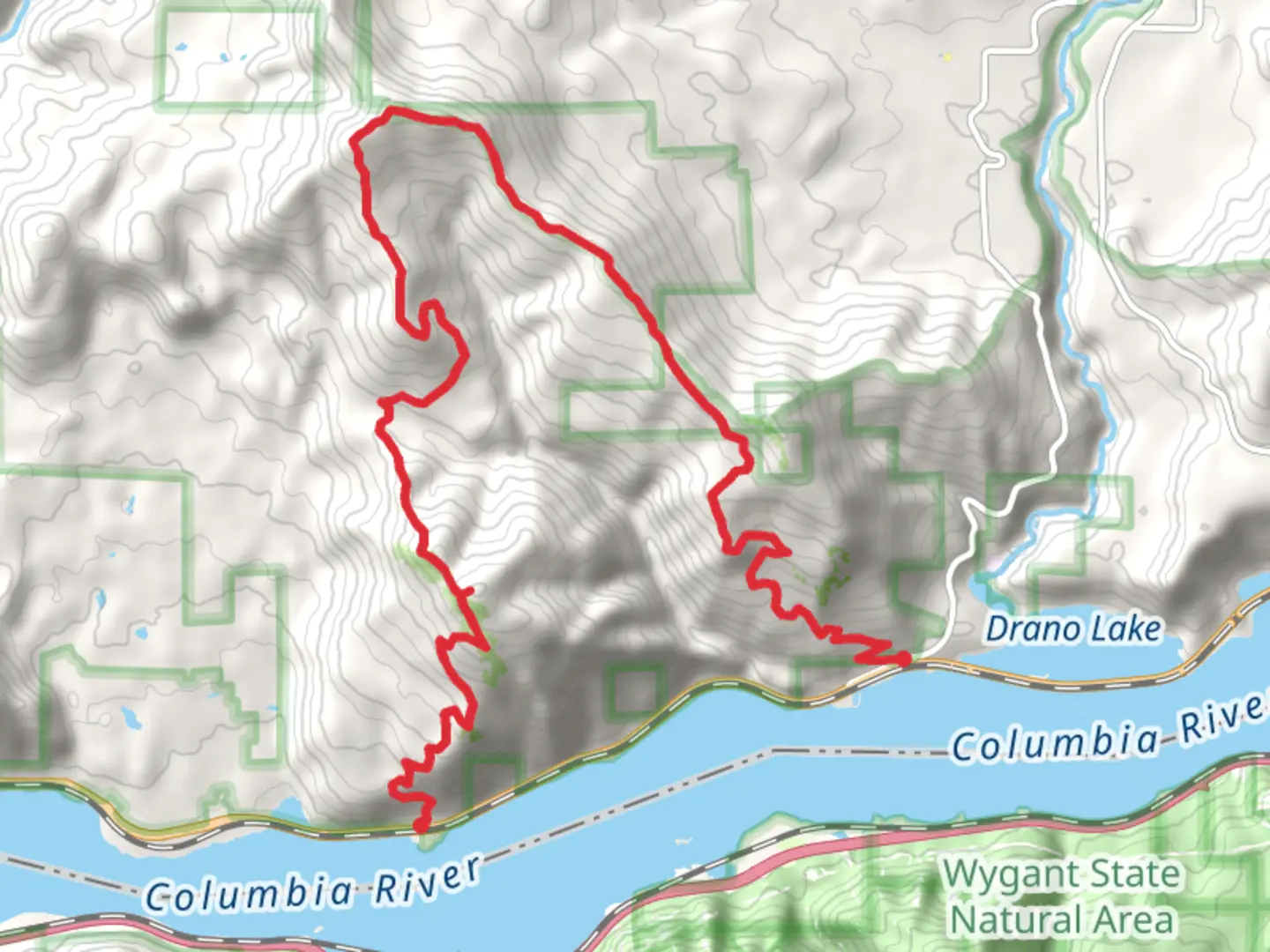
Starting near Skamania County, Washington, the Dog Mountain and Augspurger Mountain Trail is a point-to-point hike that spans approximately 22 km (13.7 miles) with an elevation gain of around 1500 meters (4921 feet). This trail is rated as medium difficulty, making it suitable for hikers with some experience and a good level of fitness.
Getting There
To reach the trailhead, you can drive or use public transport. If driving, head towards the Dog Mountain Trailhead, located off State Route 14 near the town of Bingen, Washington. For those using public transport, the nearest significant landmark is the town of Stevenson, Washington. From Stevenson, you can take a local shuttle service or a taxi to the trailhead.
Trail Overview
The trail begins with a steep ascent through dense forest, providing a challenging start. After about 3 km (1.9 miles), you'll reach the first viewpoint, offering stunning vistas of the Columbia River Gorge. This is a great spot to take a break and hydrate.
Flora and Fauna
As you continue, the trail opens up into meadows filled with wildflowers, especially vibrant in late spring and early summer. Look out for lupines, Indian paintbrush, and balsamroot. Wildlife is abundant; you might spot black-tailed deer, various bird species, and even the occasional black bear. Always keep a safe distance from wildlife and follow Leave No Trace principles.
Dog Mountain Summit
At approximately 5 km (3.1 miles) in, you'll reach the summit of Dog Mountain. The elevation here is around 975 meters (3200 feet). The panoramic views of the Columbia River Gorge are breathtaking, making this a popular spot for photos. On clear days, you can see Mount Hood to the south.
Transition to Augspurger Mountain
From Dog Mountain, the trail descends slightly before beginning the ascent to Augspurger Mountain. This section is less trafficked, offering a more solitary experience. The trail here is narrower and can be overgrown in places, so it's advisable to use a navigation tool like HiiKER to stay on track.
Augspurger Mountain Summit
The climb to Augspurger Mountain is more gradual but still challenging. At around 15 km (9.3 miles) in, you'll reach the summit, which stands at approximately 1100 meters (3609 feet). The views here are equally impressive, with a different perspective of the Columbia River Gorge and surrounding peaks.
Historical Significance
The area around the Columbia River Gorge has a rich history. It was a significant trade route for Native American tribes long before European settlers arrived. The Lewis and Clark Expedition also passed through this region in the early 19th century. Keep an eye out for interpretive signs along the trail that provide more historical context.
Descent and Trail End
The descent from Augspurger Mountain is gradual, winding through mixed forests and meadows. The trail ends near the town of Home Valley, Washington. This section is about 7 km (4.3 miles) long and offers a peaceful conclusion to your hike.
Safety and Preparation
Given the elevation gain and length of the trail, it's crucial to be well-prepared. Carry plenty of water, snacks, and a first-aid kit. Weather can change rapidly, so bring layers and rain gear. Always let someone know your plans and estimated return time. Using HiiKER for navigation can help ensure you stay on the correct path and avoid any potential hazards.
This trail offers a mix of challenging climbs, stunning views, and rich history, making it a rewarding experience for those who are well-prepared.

What to expect?
Activity types
Comments and Reviews
User comments, reviews and discussions about the Dog Mountain and Augspurger Mountain Trail, Washington.
4.67
average rating out of 5
9 rating(s)