Download
Preview
Add to list
More
5.4 km
~1 hrs 19 min
153 m
Out and Back
“Discover the Coyote Creek Trail's lush forests, historical artifacts, and stunning views on a moderately challenging hike.”
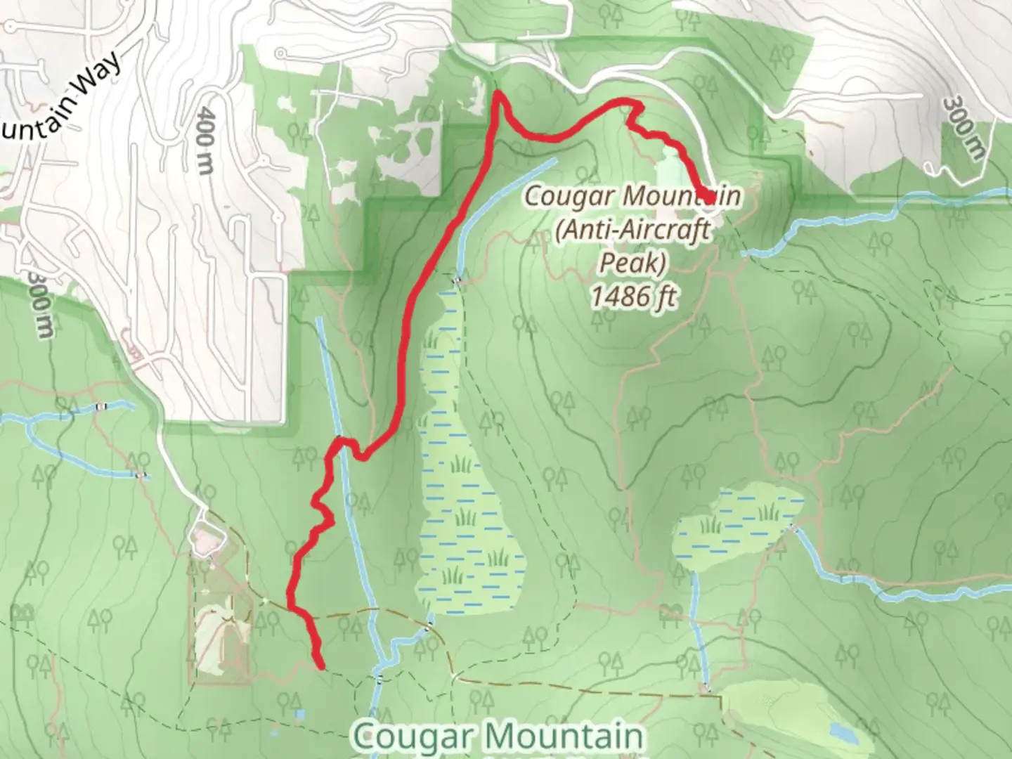
Starting your adventure near King County, Washington, the Coyote Creek Trail and Shangri La Trail offer a delightful 5 km (approximately 3.1 miles) out-and-back journey with an elevation gain of around 100 meters (328 feet). This trail is rated as medium difficulty, making it suitable for moderately experienced hikers.### Getting There To reach the trailhead, you can drive or use public transportation. If driving, set your GPS to the nearest known address: 12345 SE 8th St, Bellevue, WA 98005. For those using public transport, take the King County Metro bus to the Bellevue Transit Center, then transfer to a local bus that stops near SE 8th St. From there, it's a short walk to the trailhead.### Trail Overview The trail begins with a gentle ascent through a lush forest of Douglas firs and western red cedars. The first 1 km (0.6 miles) is relatively easy, with a well-maintained path that gradually climbs about 30 meters (98 feet). Keep an eye out for the diverse bird species that inhabit this area, including woodpeckers and chickadees.### Significant Landmarks At around the 1.5 km (0.9 miles) mark, you'll encounter a small wooden bridge crossing Coyote Creek. This is a great spot to pause and enjoy the serene sounds of the flowing water. The bridge also marks the beginning of a steeper section, where the trail gains another 50 meters (164 feet) in elevation over the next 1 km (0.6 miles).### Historical Significance As you continue, you'll come across remnants of old logging operations from the early 20th century. These historical artifacts, such as rusted machinery and abandoned rail tracks, offer a glimpse into the region's industrial past. The area was once a bustling hub for timber extraction, which played a significant role in the development of King County.### Flora and Fauna The trail is rich in native flora, including sword ferns, salal, and Oregon grape. During spring and summer, wildflowers like trillium and bleeding heart add splashes of color to the landscape. Wildlife is abundant, with chances to spot deer, raccoons, and even the occasional black bear. Always keep a safe distance and never feed the animals.### Navigation and Safety For navigation, it's highly recommended to use the HiiKER app, which provides detailed maps and real-time updates. The trail is well-marked, but having a reliable navigation tool ensures you stay on track, especially in areas where the path may be less defined.### Final Stretch The final 1.5 km (0.9 miles) of the trail leads you to the Shangri La viewpoint, offering panoramic views of the surrounding valleys and distant mountain ranges. This section is relatively flat, allowing you to catch your breath and take in the stunning scenery. The viewpoint is an ideal spot for a picnic or a moment of reflection before retracing your steps back to the trailhead.### Preparation Tips Ensure you wear sturdy hiking boots, as the trail can be muddy, especially after rain. Bring plenty of water, snacks, and a first-aid kit. Weather in this region can be unpredictable, so pack a rain jacket and dress in layers. Always let someone know your hiking plans and estimated return time.Embark on this trail with a sense of adventure and respect for the natural and historical elements that make it unique.

What to expect?
Activity types
Comments and Reviews
User comments, reviews and discussions about the Coyote Creek Trail and Shangri La Trail, Washington.
4.29
average rating out of 5
7 rating(s)