Download
3D Flyover
Add to list
More
48.9 km
~3 days
1798 m
Out and Back
“The Fore Mountain Trail offers seasoned hikers breathtaking vistas, rich history, and a demanding, rewarding adventure.”
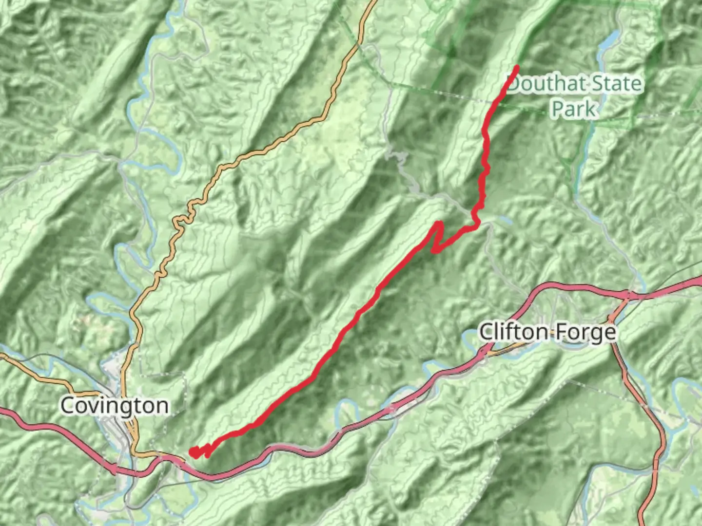
Starting your adventure near Alleghany County, Virginia, the Fore Mountain Trail from Smokey Bear Lane offers a challenging yet rewarding experience for seasoned hikers. This out-and-back trail stretches approximately 49 kilometers (about 30.4 miles) with an elevation gain of around 1,700 meters (5,577 feet), making it a difficult trek that demands preparation and endurance.
Getting There
To reach the trailhead, head towards the vicinity of Alleghany County. If you're driving, you can park near Smokey Bear Lane, which is accessible via local roads. For those relying on public transport, the nearest major hub is in Covington, Virginia. From there, you may need to arrange a taxi or rideshare to reach the trailhead, as public transport options directly to the start are limited.
Trail Overview
The Fore Mountain Trail is renowned for its rugged terrain and breathtaking vistas. As you embark on this journey, you'll traverse through dense forests, open meadows, and rocky outcrops. The trail is well-marked, but it's advisable to use HiiKER for navigation to ensure you stay on course, especially in areas where the path may become less distinct.
Significant Landmarks and Nature
Around 10 kilometers (6.2 miles) into the hike, you'll encounter a stunning viewpoint offering panoramic views of the surrounding Alleghany Highlands. This is an ideal spot for a rest and to soak in the natural beauty. As you continue, the trail meanders through diverse ecosystems, home to a variety of wildlife including white-tailed deer, black bears, and numerous bird species. Keep your eyes peeled for the vibrant flora, especially during spring and fall when the colors are most vivid.
Historical Significance
The region around Fore Mountain is steeped in history. During the hike, you'll pass through areas that were once traversed by Native American tribes and later by early European settlers. The trail itself follows parts of old logging routes, remnants of the area's past economic activities. This historical backdrop adds a layer of intrigue to your hike, as you walk paths that have been used for centuries.
Elevation and Terrain
The trail's elevation gain of 1,700 meters (5,577 feet) is spread across its length, with several steep sections that will test your stamina. The ascent is gradual in some parts but can be quite steep and rocky in others, requiring careful footing. The highest point of the trail offers a rewarding view, making the climb worthwhile.
Preparation and Safety
Given the trail's difficulty, it's crucial to be well-prepared. Ensure you have adequate water, food, and appropriate gear for changing weather conditions. The trail can be remote, so a first-aid kit and emergency supplies are recommended. Cell service may be spotty, so downloading the trail map on HiiKER before you set out is a wise precaution.
Embarking on the Fore Mountain Trail is a journey through both natural beauty and historical landscapes, offering a challenging yet fulfilling experience for those ready to take it on.

What to expect?
Activity types
Comments and Reviews
User comments, reviews and discussions about the Fore Mountain Trail from Smokey Bear Lane, Virginia.
average rating out of 5
0 rating(s)