Download
3D Flyover
Add to list
More
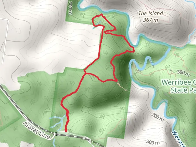
33.0 km
~2 days
785 m
Multi-Day
“Trek through the Brisbane Ranges on the Burchell Trail, a medium-difficulty hike amidst historical sites and vibrant ecosystems.”
The Burchell Trail, winding through the diverse landscapes of the Brisbane Ranges National Park near Golden Plains, Victoria, offers hikers an immersive experience into the Australian bush. Spanning approximately 33 kilometers (about 20.5 miles) with an elevation gain of around 700 meters (about 2300 feet), this point-to-point trail is rated as medium difficulty, making it accessible to hikers with a reasonable level of fitness.
Getting to the Trailhead
To reach the trailhead, you can drive or take public transport. By car, the starting point is most easily accessed from Geelong. Take the Geelong-Ballan Road towards Anakie, and follow the signs to the Brisbane Ranges National Park. The trail begins near the Anakie Gorge Picnic Area, which is well-signed and offers parking.
For those opting for public transport, take a train from Melbourne to Geelong, then board a bus towards Ballan, alighting at Anakie. From there, it's a short walk to the trailhead. It's important to check the latest schedules as services may be limited.
Navigating the Trail
As you embark on the Burchell Trail, ensure you have the HiiKER app downloaded for up-to-date navigation and trail information. The trail is well-marked with signage, but having a digital tool can enhance your experience and provide peace of mind.
Trail Highlights and Landmarks
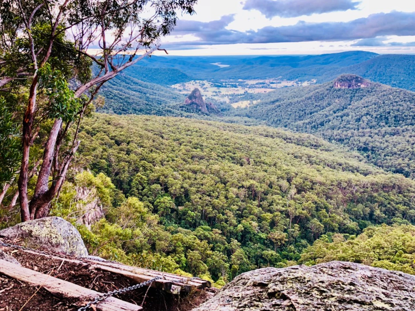
The journey begins amidst the Anakie Gorge's rugged terrain, where you'll be greeted by the sounds of native birds and the sight of towering eucalyptus trees. The first section of the trail is relatively flat, allowing you to ease into the hike.
As you progress, the trail takes you through a variety of landscapes, including woodlands, heathlands, and grassy plains. Around the 10-kilometer (6.2 miles) mark, you'll reach the Stony Creek Picnic Area, a perfect spot for a rest and a snack.
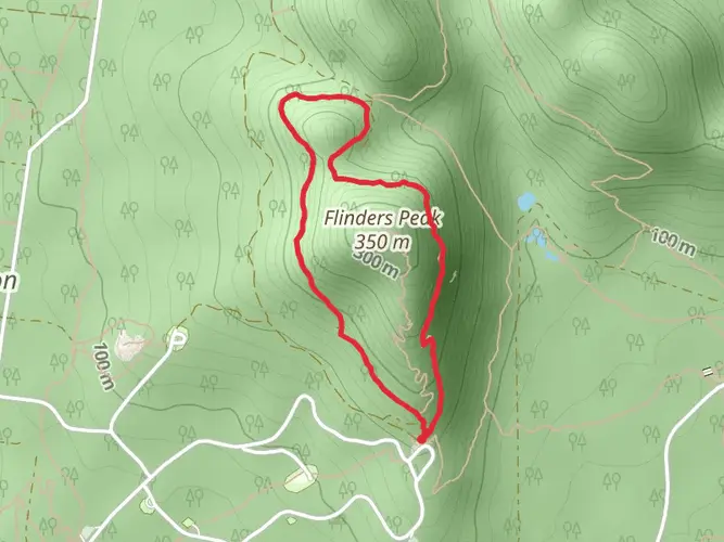
Continuing on, the trail becomes more challenging with steeper sections leading to the park's higher elevations. Here, you'll be rewarded with panoramic views of the surrounding area. Keep an eye out for the park's diverse wildlife, including kangaroos, wallabies, and an array of bird species.
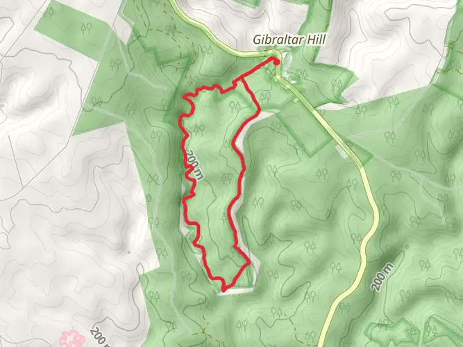
The trail's midpoint features the historic Old Mill Site, where remnants of the gold rush era can be seen. This area serves as a reminder of the region's rich history and the impact of European settlement.
Flora and Fauna
The Brisbane Ranges are known for their biodiversity, particularly the wildflowers that bloom in spring. Orchids, grevilleas, and wattles add splashes of color to the landscape. The park is also home to the endangered Brush-tailed Rock-wallaby, so keep a lookout for these elusive creatures.
Preparing for the Hike
Before setting out, ensure you have adequate water, as sources along the trail are not always reliable. Weather in the region can be unpredictable, so pack layers and be prepared for both sun and rain. As the trail can be completed over two days, consider arranging accommodation at one of the designated campgrounds along the route.
Conclusion
The Burchell Trail offers a rich hiking experience through the heart of the Brisbane Ranges. With its historical significance, diverse ecosystems, and stunning vistas, it's a journey that provides both a physical challenge and an opportunity to connect with the natural beauty of Victoria.

What to expect?
Frequently asked questions
How long does the Burchell Trail take to hike in Brisbane Ranges National Park?
The Burchell Trail is commonly done as a 3-day point-to-point walk in Brisbane Ranges National Park. Parks Victoria describes it as about 40 km with two overnight hike-in campgrounds, while this mapped route is 33.01 km with 785 m of climbing, so most hikers split it into three moderate days between the southern and northern ends of the park.
Where do you start and finish the Burchell Trail in Victoria?
The Burchell Trail can be walked in either direction through Brisbane Ranges National Park. The usual end points are Fridays Campground at the southern end of the park and Boar Gully Campground at the northern end, with road access via Geelong-Ballan Road for the south and Thompsons Road or Reids Road for the north.
Are there campsites on the Burchell Trail for an overnight hike?
Yes. There are two hike-in campgrounds on the Burchell Trail: Old Mill Hike-in Campground and Little River Hike-in Campground. Each has two sites for up to six people per site, plus non-flushing toilets, picnic tables, a shared wood BBQ, and tank water that is not suitable for drinking, and advance booking is required.
Can you do the Burchell Trail as an easy multi-day hike?
The Burchell Trail is a multi-day walk with 33.01 km of distance and 785 m of elevation gain on this route, so it is manageable for hikers with decent day-walking fitness. Even though it is rated easy here, Parks Victoria warns of steep sections, uneven ground, slippery surfaces, snakes, and areas with no mobile phone reception, so it still needs solid preparation.
Are dogs allowed on the Burchell Trail in Brisbane Ranges National Park?
No. Dogs are not allowed on the Burchell Trail in Brisbane Ranges National Park. Parks Victoria lists the walk under national park restrictions where dogs are prohibited, with the usual exception that assistance dogs may be permitted subject to entry requirements.
Is parking available at the Burchell Trail trailheads?
Yes. The standard trail access points are Fridays Campground and Boar Gully Campground, and both are reached by road within Brisbane Ranges National Park. The southern access is typically approached from Geelong-Ballan Road, while the northern access is usually via Thompsons Road or Reids Road, making car access the simplest option for a point-to-point hike.
What are the main highlights on the Burchell Trail in the Brisbane Ranges?
The Burchell Trail crosses Brisbane Ranges National Park through rugged bushland and is known for wildflower displays and broad views across Wadawurrung Country. The route links existing walking tracks, management tracks, and some public road sections, and the named overnight stops at Old Mill and Little River break up the walk into distinct stages.
Comments and Reviews
User comments, reviews and discussions about the Burchell Trail, Victoria.
4.57
average rating out of 5
7 rating(s)