Download
3D Flyover
Add to list
More
8.1 km
~1 hrs 57 min
203 m
Loop
“A switchback climb to South Peak melts into tranquil pondside woods, blending panorama, history, and quiet reflection.”
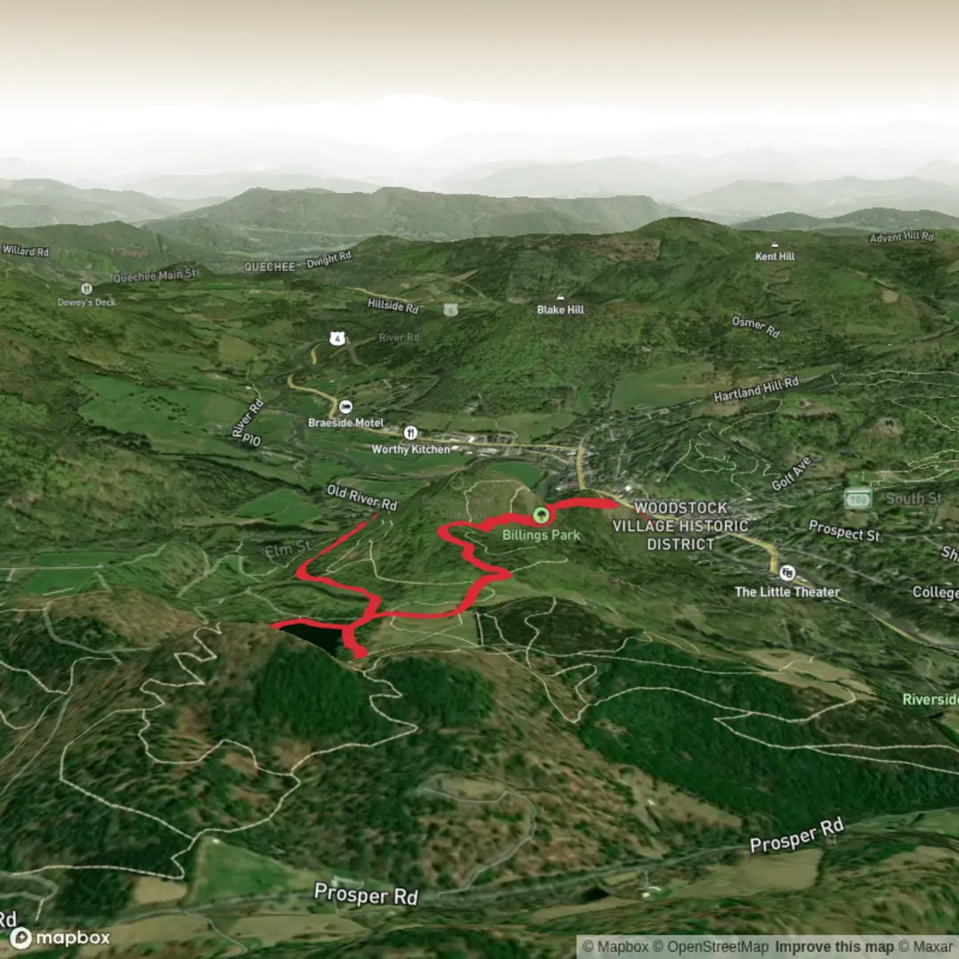
This roughly 8 km / 5 mi outing links one of Woodstock’s classic village-to-summit climbs with the carriage roads and pond circuit of Mount Tom, creating a varied medium-difficulty walk with steady but generally manageable climbing of about 200 m / 650 ft. Starting near Faulkner Park, 34 Mountain Ave, Woodstock, Vermont 05091, the route typically begins on the Faulkner Trail, a well-known local path that rises by a series of switchbacks toward Mount Tom’s South Peak before continuing into the wider trail and carriage-road network around The Pogue in Marsh-Billings-Rockefeller National Historical Park. The Faulkner Trail itself is listed by the National Park Service as about 2.75 miles / 4.4 km round trip to South Peak, while the broader Mount Tom–Pogue combinations extend that into a longer loop more in line with your stated 8 km / 5 mi day. (npshistory.com)
The opening climb is usually the most sustained part of the hike. The Faulkner Trail is popular because it gains height efficiently without feeling brutally steep, using gentle switchbacks through mixed woodland. Even so, hikers should not underestimate the final approach to South Peak: near the top, the smoother tread gives way to rock outcrops, uneven footing, and a short rougher section over the last 100 yards / 90 m or so. Good shoes with reliable grip are worthwhile, especially after rain, when roots, stone, and leaf litter can become slick. (npshistory.com)
One of the first major rewards is the South Peak overlook, where benches and open views look out across Woodstock village and the surrounding hills. This is the signature viewpoint on the Faulkner side of Mount Tom and a highlight for anyone wanting a relatively short climb with a strong scenic payoff. South Peak is also home to Woodstock’s town star, illuminated in winter and visible from a distance. (npshistory.com)
Terrain, route character, and what to expect
After the South Peak viewpoint, the character of the hike changes. Instead of a simple up-and-back, the route toward The Pogue broadens into the historic Mount Tom landscape of carriage roads, forest tracks, and pond-side walking. This makes the full outing feel more varied than the numbers suggest: part village-access footpath, part summit walk, and part historic estate forest ramble. The carriage-road sections are generally easier underfoot than the upper rocky bits of the Faulkner Trail, but they can still be muddy in wet periods and snowy or icy in colder months. (nps.gov)
The Pogue itself is a 14-acre man-made pond set within the Mount Tom Forest. It adds a quieter, more reflective section to the hike after the climb, with calmer water views and a more enclosed woodland atmosphere than the open panorama from South Peak. Swimming and fishing are not permitted there, so hikers should expect it to feel more like a protected landscape feature than a recreation lake. (nps.gov)
Because this route combines different trail systems, it is worth checking the exact loop you intend to follow before setting out. For navigation, use HiiKER and download your route in advance, as tree cover and terrain can make on-the-ground junctions feel less obvious than they appear on a simple map. That is especially helpful where the Faulkner Trail connects into the broader Woodstock and national historical park network. The National Park Service notes that Woodstock has more than 30 miles / 48 km of interconnected trails linking the village, Mount Tom, and surrounding public lands, so it is easy to add distance unintentionally if you miss a turn. (nps.gov)
Nature and wildlife
The natural setting is one of the most interesting parts of this hike because Mount Tom is not just a scenic hill above town; it is also part of a historically managed forest landscape. The woods here include plantations and stands associated with long-term forestry work, including Norway spruce, eastern white pine, red pine, Scotch pine, and European larch. That gives the walk a different feel from a purely wild backcountry trail: you are moving through a landscape shaped by both ecology and deliberate stewardship. (nps.gov)
Wildlife sightings vary by season, but hikers should

Surfaces
Unknown
Unpaved
Comments and Reviews
User comments, reviews and discussions about the Mount Tom and The Pogue via Faulkner Trail, Vermont.
average rating out of 5
0 rating(s)