Crystal Cascade Falls, Gus's Lookout and Mt Ascutney via Wethersfield Trail
Download
3D Flyover
Add to list
More
8.3 km
~2 hrs 40 min
618 m
Out and Back
“A steep, splashy climb rewards determined hikers with waterfalls, airy ledges, and widening summit views.”
This difficult out-and-back on Mount Ascutney packs a lot into roughly 8 km / 5 miles, though many hikers should expect closer to about 9.3 km / 5.8 miles if continuing all the way to the summit from the Weathersfield Trailhead. Total climbing is substantial at around 600 m / 1,970 ft, and the official Weathersfield Trail figures put the summit at 2.9 miles one way with about 2,062 ft / 628 m of ascent from the parking area. Along the way, the route links one of the mountain’s best waterfalls with a series of increasingly broad viewpoints, including Gus’s Lookout and the upper ledges near Mount Ascutney’s summit. (a08f33fc-d692-4de7-b0a6-29f2300cdb6c.filesusr.com)
The hike begins near the Weathersfield Trailhead at Cascade Falls Road, Weathersfield, VT 05151, the signed access point used for the Wethersfield/Weathersfield Trail on Mount Ascutney. If arriving by car, this is the most useful address for navigation and parking. The trailhead lies on the south side of the mountain in Weathersfield, a short drive from Interstate 91 and the villages around Ascutney and Windsor. (ascutneytrails.com)
Public transport is limited, so most hikers will find a car far more practical. The nearest regional rail option is the Windsor/Ascutney area, and local transit in the broader area includes the MicroMoo service connecting residents around Hartland, Ascutney, and Windsor to Exit 8, where the Route 101 Shopper bus can be reached. Because service patterns can be limited and may not line up neatly with trailhead access, hikers relying on transit should verify schedules in advance and be prepared for a taxi or rideshare gap for the final approach. (weathersfieldvt.org)
What the climb feels like
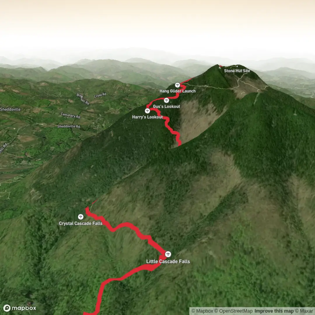
The opening section is one of the most rewarding parts of the day. The trail climbs through hardwood forest toward Little Cascade Falls at about 0.4 miles / 0.6 km, then continues to Crystal Cascade Falls at about 1.1 miles / 1.8 km. The footing here can be slick from spray, wet leaves, mud, and exposed roots, especially after rain or during spring runoff. The main falls drop roughly 84 ft / 26 m and are one of the standout natural landmarks on this route. (a08f33fc-d692-4de7-b0a6-29f2300cdb6c.filesusr.com)
Beyond the falls, the route becomes more demanding. The trail turns steeper, crosses Cascade Brook, then works upward on old woods-road grades and switchbacks. Around Halfway Brooks at 1.7 miles / 2.7 km, water may be present but can run dry at times, so it should not be treated as a guaranteed refill point. From there, the climb continues through mixed forest with occasional openings through the trees. (a08f33fc-d692-4de7-b0a6-29f2300cdb6c.filesusr.com)
At about 2.3 miles / 3.7 km, hikers reach Gus’s Lookout, a broad rock viewpoint with expansive southern views. This is a natural turnaround point for anyone wanting a shorter but still strenuous outing. If continuing, the trail climbs past a large boulder and toward the West Peak cutoff at about 2.5 miles / 4.0 km, with nearby ledges and open areas adding even more scenery before the final push to the summit ridge. The last section is shorter than the earlier climb but still steep enough to feel serious late in the hike. (a08f33fc-d692-4de7-b0a6-29f2300cdb6c.filesusr.com)
Landmarks, terrain, and what to watch for
Crystal Cascade Falls is the signature feature early on, but the route keeps changing character. Lower down, expect a shaded forest climb with brook crossings, damp ground, and mossy rock. Mid-mountain, the trail alternates between hardwoods and conifers, and the grade becomes more sustained. Higher up, the mountain opens into ledges and outlooks where wind exposure increases and temperatures can feel noticeably cooler than at the trailhead. (a08f33fc-d692-4de7-b0a6-29f2300cdb6c.filesusr.com)
Gus’s Lookout is especially important for planning because it gives a strong sense of the mountain’s exposure. If weather is moving in, this is a good place to reassess. Wet rock slabs can be slippery, and in shoulder seasons the

Surfaces
Dirt
Unknown
Ground
Comments and Reviews
User comments, reviews and discussions about the Crystal Cascade Falls, Gus's Lookout and Mt Ascutney via Wethersfield Trail, Vermont.
average rating out of 5
0 rating(s)