Download
3D Flyover
Add to list
More
5.1 km
~1 hrs 25 min
242 m
Loop
“A short, soulful ridge ramble through shadowy hemlocks to sunlit ledges and sweeping Vermont horizons.”
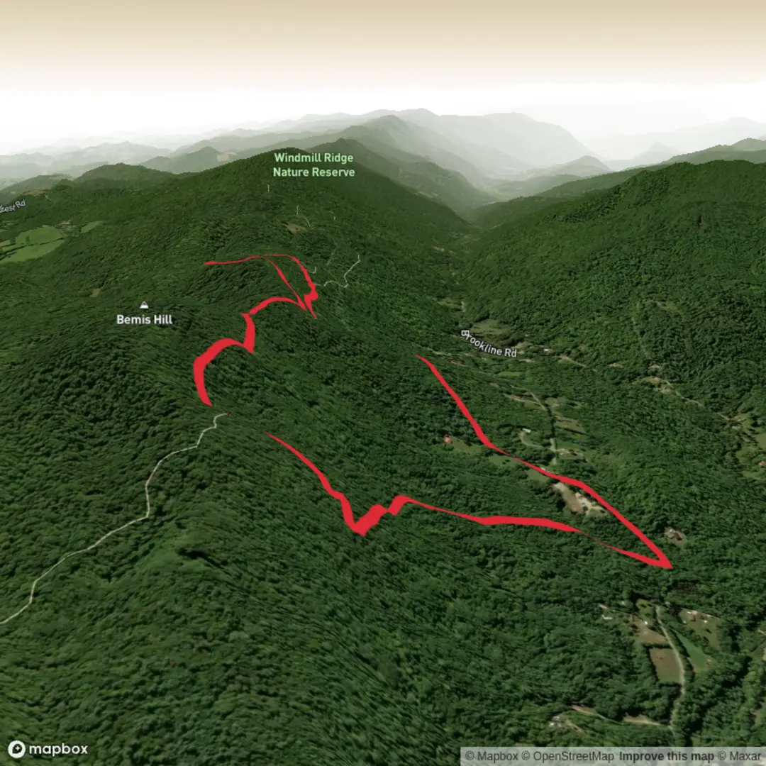
This roughly 5 km / 3.1 mi outing to Paul Ledge’s via the Athens Access Trail and Undercliff Trail is a compact but rewarding ridge hike in Athens, Vermont, with about 200 m / 656 ft of climbing spread over a steady ascent rather than one single brutal push. The route begins near the Athens Access Trailhead at 37 Valley Cemetery Road, Athens, VT, a small parking area off a quiet rural road, and climbs through dense forest to a ridgeline network maintained by the Windmill Hill Pinnacle Association. The overall feel is of a moderate woodland hike with a scenic payoff, interesting geology, and a few sections where footing and route choices deserve attention. (trailfinder.info)
The first part of the walk is the work phase. From the trailhead, the Athens Access Trail rises about 0.8 miles / 1.3 km through hemlock forest, gaining most of the elevation early. This section is steep enough to raise the heart rate, especially when the ground is damp or covered in leaves, but it is not especially long. As the trail nears the ridge, the grade eases and the forest begins to open into northern hardwoods. For hikers planning timing, this usually means a shorter climb followed by a more relaxed traverse toward the ledges. (windmillhillpinnacle.org)
Along the ridge
Once you meet the ridge trail system, the character of the hike changes. The Hemlock Trail and connecting paths run through attractive mixed forest, with some sections cut into the hillside and others passing beneath impressive hemlocks. The Undercliff Trail then provides the more dramatic approach to Paul Ledge’s, tracking below rock outcrops and ledgy terrain. This is one of the most distinctive parts of the route: expect a narrower footpath in places, uneven tread, roots, and rocky footing rather than smooth walking. The terrain is not technical, but hikers should move carefully after rain, during leaf fall, or in shoulder-season freeze-thaw conditions when slick rock and damp soil can make the trail feel more serious than the mileage suggests. (trailfinder.info)
Paul Ledge’s itself is an open grassy ledge area with a picnic table and broad west-facing views. On a clear day, the Green Mountains dominate the horizon, with Stratton Mountain standing out as the highest point in southern Vermont. Because the viewpoint is open and grassy rather than hemmed in by trees, it feels more spacious than many forested New England overlooks. That openness also means more exposure to sun and wind than you may have felt lower down in the woods. (trailfinder.info)
Landmarks, nature, and wildlife
This trail system packs a lot into a short distance. Beyond the overlook itself, the area is known for hemlock stands, rock outcrops, a glacial erratic elsewhere in the network, and managed wildlife clearings designed to support early-successional habitat. At Paul Ledge’s, the open area partly reflects the site of a former home, which helps explain the unusually park-like feel at the viewpoint. The clearing has also encouraged grasses, raspberries, and blackberries, and the area has been noted as a place used by black bears and deer. That does not mean sightings are guaranteed, but it does mean hikers should stay alert, keep food secured, and give wildlife plenty of space. Birdlife can also be active around edge habitat where forest meets clearing. (trailfinder.info)
The surrounding forest is part of a conserved landscape in the Athens Dome area. Conservation work here has aimed not only to protect the land but also to improve habitat diversity and long-term forest resilience. Standing dead trees are intentionally left in some managed areas for cavity-nesting birds such as woodpeckers, and some openings are maintained to encourage a mix of young growth and mast-producing trees. For hikers, that means the landscape is not just scenic; it is also actively managed as habitat. (windmillhillpinnacle.org)
Historical significance of the area
The region carries a quiet rural history that shows up in the trail network itself. Old County Road, nearby stone walls, and the former homesite at Paul Ledge’s all point to an earlier agricultural and settlement landscape that has gradually returned to forest. In southern Vermont, these traces are common reminders of 18th- and 19th-century hill farming, when land that now feels remote was more actively occupied and worked. The present trail system overlays that older human geography, so hikers move through both natural and cultural history at the same time. The modern conservation of the Athens Dome forest by the Windmill Hill Pinnacle Association, with support from Vermont conservation partners, adds a more recent chapter focused on land protection and habitat restoration.

Surfaces
Unknown
Gravel
Comments and Reviews
User comments, reviews and discussions about the Paul Ledge's via Athens Access Trail and Undercliff Trail, Vermont.
average rating out of 5
0 rating(s)