Download
3D Flyover
Add to list
More
6.3 km
~1 hrs 52 min
363 m
Loop
“A steep woodland climb rewards prepared hikers with a historic fire tower and whimsical Balancing Rock.”
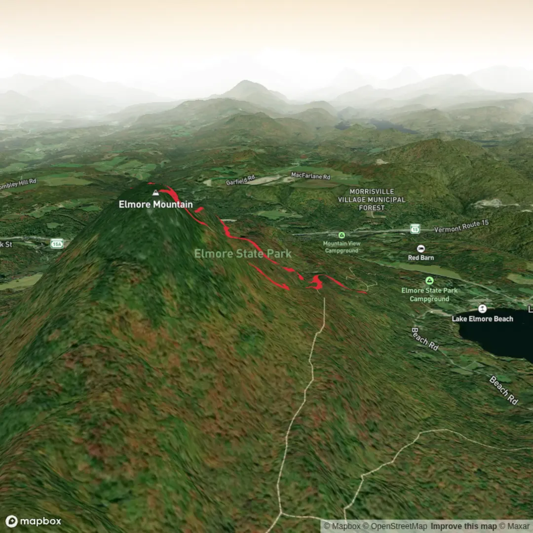
This roughly 6 km / 3.7 mi outing on Elmore Mountain is one of the most rewarding moderate hikes in north-central Vermont, combining a steady forest climb, a historic fire tower, and the striking Balancing Rock on the ridge. The route is usually described as a loop using the Fire Tower Trail for the ascent and the Ridge Trail for the return, with total elevation gain around 400 m / 1,300 ft. Official park mapping shows the Fire Tower Trail at about 1.74 mi one way to the summit area, the Ridge Trail at about 2.3 mi one way, and Balancing Rock about 0.52 mi from the fire tower, which fits well with a loop of roughly 6 km to 6.5 km / about 3.7 to 4 mi depending on exactly where you start in the parking area. (vtstateparks.com)
The hike begins at Elmore State Park, near 856 VT Route 12, Elmore, VT 05657, beside Lake Elmore. That is the clearest known address for the hike start and the main landmark most hikers use. From the day-use and trailhead parking, the route heads inland from the lake and quickly begins climbing through mixed northern hardwood forest. Expect a moderate effort overall, but not a uniformly easy one: the lower sections are more gradual, while the upper Fire Tower Trail becomes noticeably steeper and rockier, especially near the summit. Vermont State Parks notes that the final 0.16 mi / 0.26 km to the fire tower is the most difficult part, with very steep, rocky footing. (vtstateparks.com)
Getting to the trailhead
By car, the simplest approach is via VT Route 12 in Lake Elmore. From Montpelier, Vermont State Parks directs drivers to take I-89 north to Exit 8 and then follow VT-12 to Lake Elmore. From the Burlington side, the park recommends taking I-89 south to Exit 10, following VT-100 north, and then connecting to VT-12 south into Lake Elmore. The park entrance is signed from the road. (vtstateparks.com)
Public transport is limited, so planning ahead matters. Elmore is about 6 miles / 9.7 km south of Morrisville on VT Route 12, and Morrisville is the nearest practical transit hub. Regional transportation service in the area includes Rural Community Transportation, which indicates service within Elmore, Morrisville, and Hyde Park, but hikers should expect that reaching the park may require advance coordination rather than a simple walk-up bus connection. (elmorevt.org)
The first part of the route is a good warm-up. Official park distances show the junction with the Ridge Trail at about 0.32 mi / 0.5 km from the trailhead, and the end of the forest road at about 0.47 mi / 0.76 km. Up to this point, the grade is comparatively gentle. After that, the Fire Tower Trail becomes more direct, climbing through woods that can feel enclosed and humid in summer and slick with roots, mud, or leaf cover in shoulder seasons. Around 1.58 mi / 2.54 km from the trailhead you reach the old cabin site area, and from there the summit push steepens further. (vtstateparks.com)
What to expect on the climb
The forest here is typical of the Worcester Range, with hardwood cover dominating much of the mountain. In warmer months, hikers can expect maple, birch, and beech woodland, with mossy rocks and fern-lined sections adding to the classic Vermont feel. Because the mountain rises sharply from near the lake, the climb feels more substantial than the raw distance suggests. Short, steep pitches can be tiring, especially after rain when rock slabs and exposed roots become slippery. (vtstateparks.com)
Wildlife is usually more heard than seen, but the area supports the kinds of animals common to northern Vermont forests: songbirds, woodpeckers, squirrels, chipmunks, and larger mammals such as deer and black bear in the broader landscape. Hikers should also be alert for insects in late spring and summer, especially mosquitoes and black flies, and should do a tick check afterward. Near the lake and lower forest, damp conditions can linger, so waterproof footwear or at least shoes with solid grip are helpful.
At the summit, Elmore Mountain reaches 2,608 ft / 795 m, and the fire tower is the defining landmark. The tower is one of Vermont’s few remaining fire towers, and it

Surfaces
Unknown
Dirt
Gravel
Unpaved
Comments and Reviews
User comments, reviews and discussions about the Elmore Mountain and Balancing Rock via Fire Tower Trail, Vermont.
average rating out of 5
0 rating(s)