Download
Preview
Add to list
More
22.3 km
~2 days
2040 m
Out and Back
“Embark on an exhilarating 22-kilometer hike through lush forests, alpine meadows, and breathtaking summit views.”
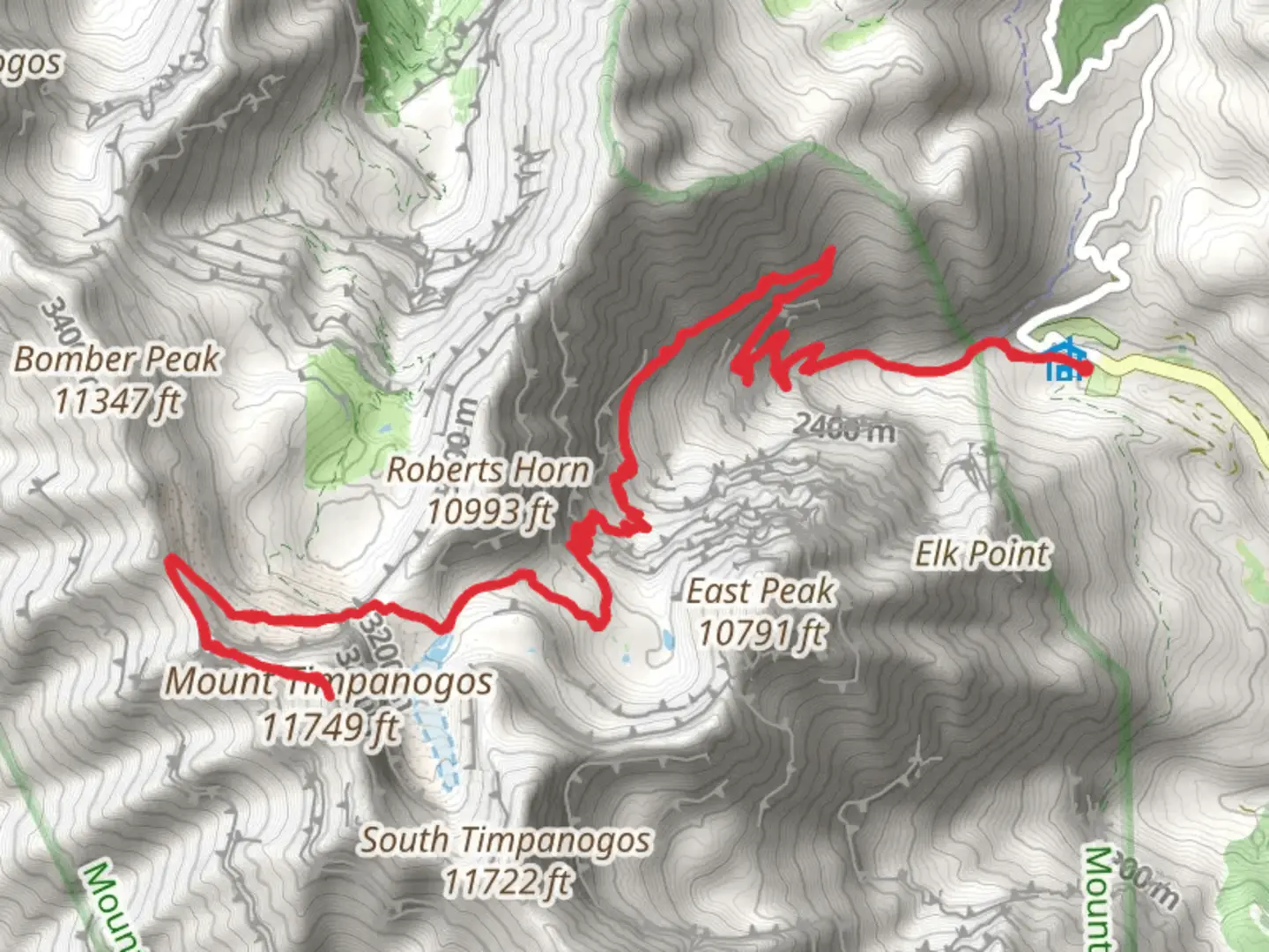
Starting your journey near Utah County, Utah, the Mount Timpanogos via Timpanogos Summit Trail offers an exhilarating adventure through the Wasatch Range. This out-and-back trail spans approximately 22 kilometers (13.7 miles) with an elevation gain of around 2000 meters (6562 feet), making it a challenging yet rewarding hike.
Getting There
To reach the trailhead, you can drive to the Timpooneke Campground, located off the Alpine Loop Scenic Byway (UT-92). If you're using public transport, the nearest major city is Provo, Utah. From Provo, you can take a bus to the American Fork Canyon area and then arrange for a taxi or rideshare to the Timpooneke Campground.
Trail Overview
The trail begins at the Timpooneke Campground, situated at an elevation of approximately 2,100 meters (6,890 feet). The initial section of the trail meanders through lush forests of aspen and pine, offering a serene start to your hike. As you ascend, you'll encounter a series of switchbacks that gradually increase in steepness.
Key Landmarks and Sections
- Scout Falls (2.5 km / 1.5 miles in): About 2.5 kilometers (1.5 miles) into the hike, you'll come across Scout Falls. This picturesque waterfall is a great spot to take a short break and enjoy the cascading water.
- Emerald Lake (8 km / 5 miles in): Continuing your ascent, you'll reach Emerald Lake at around the 8-kilometer (5-mile) mark. Nestled in a glacial basin, this lake is surrounded by wildflowers in the summer and offers stunning views of the surrounding peaks.
- Timpanogos Basin (9.5 km / 6 miles in): Just past Emerald Lake, you'll enter the Timpanogos Basin. This area is known for its alpine meadows and is a prime spot for spotting wildlife such as mountain goats and marmots.
- Summit (11 km / 7 miles in): The final push to the summit involves a steep climb up a rocky ridge. At the summit, which stands at an elevation of approximately 3,582 meters (11,750 feet), you'll be rewarded with panoramic views of the Utah Valley and the Great Salt Lake.
Historical Significance
Mount Timpanogos holds significant cultural and historical importance. The name "Timpanogos" is derived from the Timpanogots, a band of the Ute people who historically inhabited the region. The mountain is also steeped in local folklore, including the legend of the Timpanogos Cave, which is said to be the resting place of a Native American princess.
Wildlife and Flora
The trail is rich in biodiversity. In the lower elevations, you'll find dense forests of aspen and pine. As you climb higher, the vegetation transitions to alpine meadows filled with wildflowers such as Indian paintbrush and columbine. Wildlife is abundant, with frequent sightings of deer, mountain goats, and various bird species.
Navigation and Safety
Given the trail's length and elevation gain, it's crucial to be well-prepared. Ensure you have a reliable navigation tool like HiiKER to keep track of your progress and stay on course. Weather conditions can change rapidly, so pack layers and be prepared for sudden temperature drops, especially near the summit.
Final Tips
Start early to avoid afternoon thunderstorms, which are common in the summer months. Carry plenty of water and snacks, and be mindful of altitude sickness as you approach higher elevations. The trail is well-marked, but always stay vigilant and follow Leave No Trace principles to preserve the natural beauty of the area.

What to expect?
Activity types
Comments and Reviews
User comments, reviews and discussions about the Mount Timpanogos via Timpanogos Summit Trail, Utah.
4.63
average rating out of 5
19 rating(s)