Download
Preview
Add to list
More
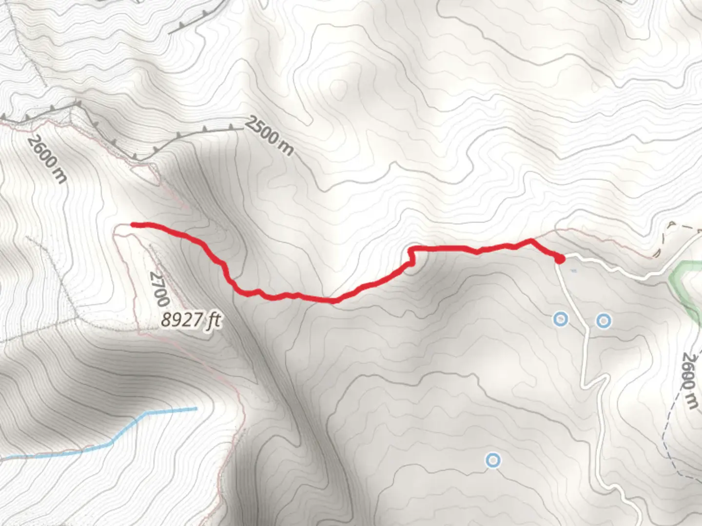
4.2 km
~1 hrs 16 min
256 m
Out and Back
“Embark on the Mahogany Mountain Trail for stunning views, rich history, and diverse wildlife in Utah.”
Starting your adventure near Utah County, Utah, the Mahogany Mountain Trail offers a rewarding out-and-back hike that spans approximately 4 km (2.5 miles) with an elevation gain of around 200 meters (656 feet). This medium-difficulty trail is perfect for those looking to experience the natural beauty and historical significance of the region.
Getting There
To reach the trailhead, you can drive or use public transport. If driving, head towards the nearest known address, which is the Dry Canyon Trailhead Parking Lot, located off 2000 N Street in Lindon, Utah. For those using public transport, the Utah Transit Authority (UTA) offers bus services that can get you close to the trailhead. From the nearest bus stop, it's a short walk to the starting point.
Trail Overview
The trail begins at the Dry Canyon Trailhead, where you'll find ample parking and basic amenities. As you start your hike, you'll immediately notice the well-maintained path that gradually ascends through a mix of scrub oak and juniper trees. The initial section is relatively easy, allowing you to warm up before the more challenging parts of the trail.
Significant Landmarks and Nature
About 1 km (0.6 miles) into the hike, you'll come across a small, picturesque creek that flows seasonally. This is a great spot to take a short break and enjoy the serene environment. Continuing on, the trail becomes steeper, and you'll start to gain elevation more rapidly. At around the 2 km (1.2 miles) mark, you'll reach a scenic overlook that offers stunning views of Utah Valley and the surrounding mountains. This is one of the most photographed spots on the trail, so make sure to have your camera ready.
Flora and Fauna
The Mahogany Mountain Trail is home to a variety of plant and animal species. Keep an eye out for wildflowers such as Indian paintbrush and lupine, especially in the spring and early summer. Wildlife sightings are common, with mule deer, wild turkeys, and even the occasional golden eagle making appearances. Always remember to respect the wildlife and maintain a safe distance.
Historical Significance
The region around Mahogany Mountain has a rich history. The trail itself was used by early settlers and Native American tribes as a route through the mountains. You might notice remnants of old cabins and mining equipment along the way, offering a glimpse into the area's past. These historical artifacts add an extra layer of intrigue to your hike, making it not just a physical journey but a historical one as well.
Navigation and Safety
Given the trail's moderate difficulty, it's advisable to use a reliable navigation tool like HiiKER to keep track of your progress and ensure you stay on the right path. The trail is well-marked, but having a digital map can provide extra peace of mind. Make sure to bring plenty of water, especially during the hotter months, and wear appropriate footwear to handle the rocky terrain.
Final Stretch
As you approach the end of the trail, the path narrows and becomes more rugged. The final ascent to the summit of Mahogany Mountain is steep but manageable. Once you reach the top, you'll be rewarded with panoramic views that make the effort worthwhile. After taking in the scenery, you can retrace your steps back to the trailhead, completing your out-and-back journey.
This hike offers a perfect blend of natural beauty, wildlife, and historical significance, making it a must-do for anyone visiting the Utah County area.

What to expect?
Activity types
Comments and Reviews
User comments, reviews and discussions about the Mahogany Mountain Trail, Utah.
4.56
average rating out of 5
18 rating(s)