Download
Preview
Add to list
More
10.5 km
~2 hrs 33 min
280 m
Out and Back
“Experience the Pipeline Short Trail's scenic beauty and historical charm on a rewarding 10 km hike.”
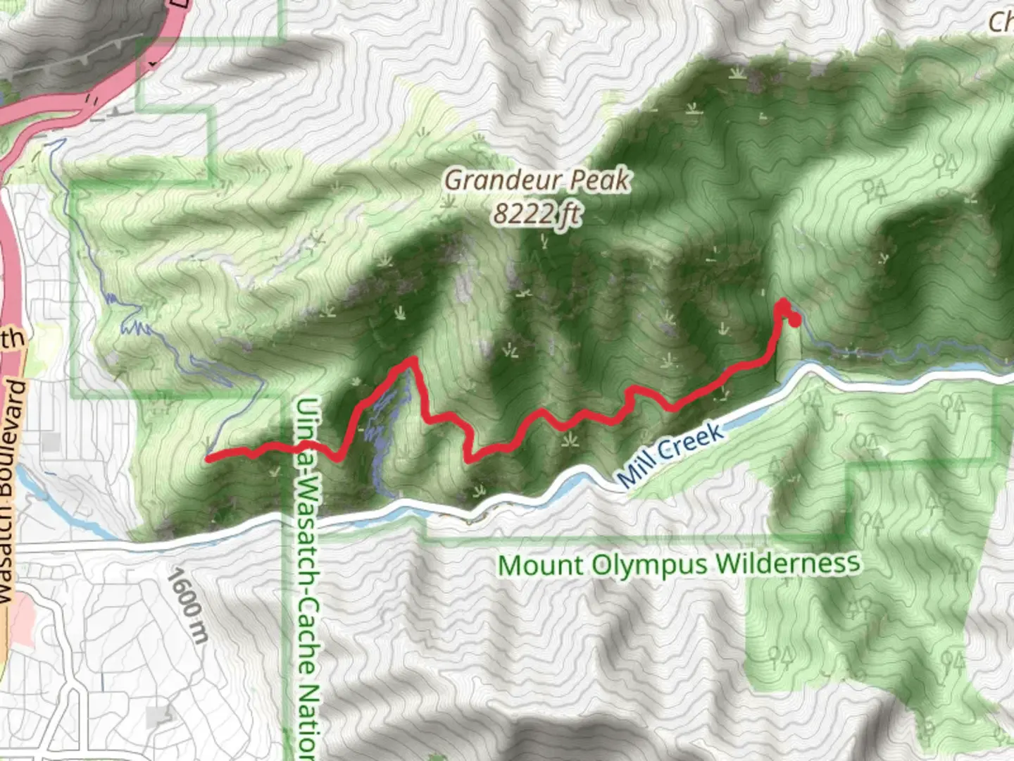
Starting near Salt Lake County, Utah, the Pipeline Short Trail offers a rewarding out-and-back hike that spans approximately 10 km (6.2 miles) with an elevation gain of around 200 meters (656 feet). This medium-difficulty trail is perfect for those looking to experience the natural beauty of the area without committing to a full-day trek.### Getting There To reach the trailhead, you can drive or use public transportation. If driving, head towards the nearest significant landmark, the Mill Creek Canyon, which is easily accessible from Salt Lake City. From there, follow the signs to the trailhead parking area. For those using public transport, take a bus to the Mill Creek Canyon area and then a short taxi or rideshare to the trailhead.### Trail Overview The Pipeline Short Trail begins with a gentle ascent, making it accessible for hikers of varying skill levels. The initial part of the trail is shaded by a canopy of trees, providing a cool and pleasant start. As you progress, the trail opens up, offering stunning views of the surrounding mountains and valleys.### Key Landmarks and Points of Interest - 0.5 km (0.3 miles): Early into the hike, you'll come across a small creek that runs parallel to the trail. This is a great spot to take a quick break and enjoy the sound of flowing water. - 2 km (1.2 miles): At this point, the trail starts to climb more steeply. You'll gain about 100 meters (328 feet) in elevation over the next kilometer, so pace yourself and take in the increasingly panoramic views. - 3 km (1.9 miles): Look out for a large rock formation on your right. This natural landmark is a popular spot for photos and offers a great vantage point to see the valley below. - 4 km (2.5 miles): The trail levels out somewhat, and you'll find yourself walking along a ridge. Here, you can see both sides of the canyon, making it one of the most scenic parts of the hike. - 5 km (3.1 miles): The turnaround point is marked by an old pipeline structure, a remnant of the area's historical significance in water transportation. This is a good spot to rest, have a snack, and prepare for the return journey.### Flora and Fauna The Pipeline Short Trail is home to a variety of plant and animal life. Depending on the season, you might see wildflowers such as lupines and Indian paintbrushes. Keep an eye out for local wildlife, including deer, squirrels, and a variety of bird species. It's not uncommon to spot a hawk or eagle soaring overhead.### Historical Significance The trail gets its name from the old pipeline that once transported water through the canyon. This pipeline was crucial for the development of the surrounding communities and serves as a historical reminder of the area's past. The remnants of the pipeline can still be seen along the trail, adding an element of historical intrigue to your hike.### Navigation For navigation, it's highly recommended to use HiiKER, which provides detailed maps and real-time updates to ensure you stay on track. The trail is well-marked, but having a reliable navigation tool can enhance your hiking experience and provide peace of mind.### Final Tips - Water: Make sure to bring enough water, especially during the warmer months. - Footwear: Wear sturdy hiking boots to navigate the rocky sections comfortably. - Weather: Check the weather forecast before heading out, as conditions can change rapidly in the mountains. - Leave No Trace: Pack out all trash and be respectful of the natural environment to preserve its beauty for future hikers.Enjoy your hike on the Pipeline Short Trail and take in the breathtaking views and rich history that this trail has to offer.

What to expect?
Activity types
Comments and Reviews
User comments, reviews and discussions about the Pipeline Short Trail, Utah.
4.57
average rating out of 5
21 rating(s)