Download
Preview
Add to list
More
12.6 km
~4 hrs 12 min
1013 m
Out and Back
“Embark on Gobblers Knob via Butler Fork Trail for breathtaking vistas and a moderate 13 km adventure.”
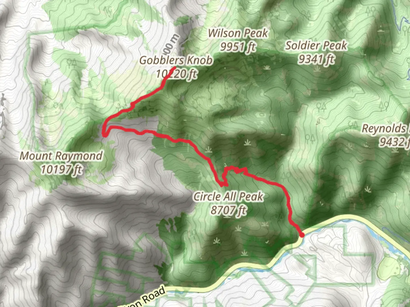
Starting your adventure near Salt Lake County, Utah, the Gobblers Knob via Butler Fork Trail is an invigorating out-and-back hike that spans approximately 13 kilometers (8 miles) with an elevation gain of around 1000 meters (3280 feet). This trail is rated as medium difficulty, making it suitable for moderately experienced hikers.### Getting There To reach the trailhead, you can drive or use public transportation. If driving, head towards the Butler Fork Trailhead, located near Big Cottonwood Canyon Road (UT-190). For those using public transport, the UTA bus service offers routes that stop near the canyon entrance, from where you can arrange a ride or hike to the trailhead.### Trail Overview The trail begins at the Butler Fork Trailhead, situated at an elevation of approximately 2,100 meters (6,890 feet). The initial section of the trail meanders through a dense forest of aspen and pine, providing ample shade and a serene atmosphere. Early in the hike, you’ll cross Butler Fork Creek, a picturesque spot perfect for a brief pause.### Key Landmarks and Sections
Mile 1 to Mile 2 (1.6 km to 3.2 km)
As you ascend, the trail becomes steeper, and you’ll encounter a series of switchbacks. Around the 2-mile (3.2 km) mark, you’ll reach a junction; take the left fork to continue towards Gobblers Knob. This section offers stunning views of the surrounding Wasatch Mountains.#### Mile 2 to Mile 4 (3.2 km to 6.4 km) The trail continues to climb steadily, and you’ll pass through open meadows filled with wildflowers during the summer months. Keep an eye out for wildlife such as mule deer and various bird species. The trail can be narrow and rocky in places, so watch your footing.#### Mile 4 to Mile 5 (6.4 km to 8 km) As you approach the summit, the terrain becomes more rugged. The final push to Gobblers Knob involves a steep ascent, but the panoramic views from the top are well worth the effort. At an elevation of approximately 3,200 meters (10,500 feet), you’ll have a 360-degree view of the Wasatch Range, including Mount Raymond and the Salt Lake Valley.### Historical Significance The Wasatch Mountains have a rich history, with evidence of Native American habitation dating back thousands of years. The area was also significant during the early days of Mormon settlement in Utah. Big Cottonwood Canyon, near the trailhead, was a crucial source of timber and water for the settlers.### Navigation and Safety Given the elevation gain and varying terrain, it’s advisable to use a reliable navigation tool like HiiKER to stay on track. Weather conditions can change rapidly, especially at higher elevations, so pack accordingly. Bring plenty of water, snacks, and layers to adjust to temperature changes.### Wildlife and Flora The trail offers a diverse range of flora and fauna. In the lower sections, you’ll find dense forests of aspen and pine, while higher elevations feature alpine meadows. Wildlife sightings can include mule deer, elk, and a variety of bird species. Always maintain a safe distance from wildlife and follow Leave No Trace principles to preserve the natural beauty of the area.### Final Stretch After soaking in the views at Gobblers Knob, retrace your steps back to the Butler Fork Trailhead. The descent offers a different perspective of the landscape, and the downhill journey is generally quicker but still requires careful navigation.This trail provides a rewarding experience with its mix of challenging climbs, stunning vistas, and rich natural and historical context. Whether you’re a local or visiting the Salt Lake County area, the Gobblers Knob via Butler Fork Trail is a must-hike for those seeking adventure and natural beauty.

What to expect?
Activity types
Comments and Reviews
User comments, reviews and discussions about the Gobblers Knob via Butler Fork Trail, Utah.
4.44
average rating out of 5
16 rating(s)