Download
Preview
Add to list
More
5.5 km
~1 hrs 24 min
185 m
Out and Back
“Discover diverse landscapes and rich history on the medium-difficulty, 6 km Tropic Trail near Bryce Canyon.”
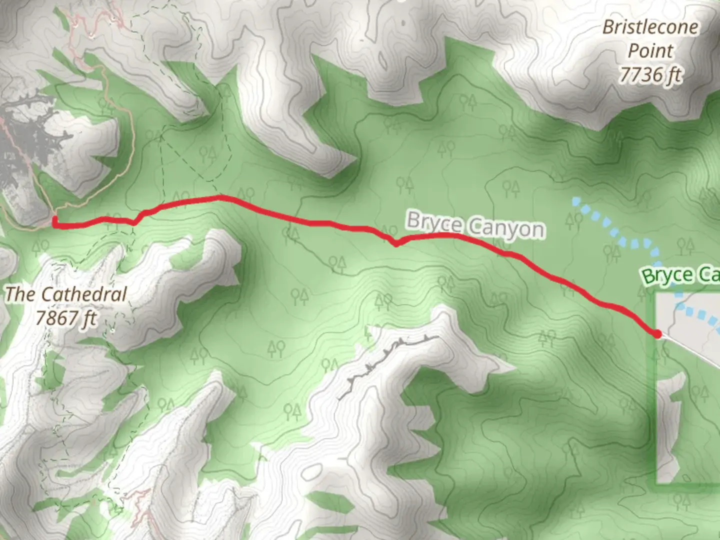
Starting near Garfield County, Utah, the Tropic Trail is an out-and-back hike spanning approximately 6 km (3.7 miles) with an elevation gain of around 100 meters (328 feet). This trail is rated as medium difficulty, making it accessible for most hikers with a moderate level of fitness.### Getting There To reach the trailhead, you can drive or use public transport. If driving, head towards Bryce Canyon National Park, and the trailhead is located near the town of Tropic. For those using public transport, the nearest significant landmark is Bryce Canyon City, which is serviced by shuttle buses from various points in Utah. From Bryce Canyon City, you can take a local shuttle or taxi to the trailhead near Tropic.### Trail Overview The trail begins with a gentle ascent, offering a gradual introduction to the terrain. As you progress, you'll encounter a mix of sandy paths and rocky sections. The first kilometer (0.6 miles) is relatively easy, with minimal elevation gain, making it a good warm-up for the more challenging parts ahead.### Significant Landmarks and Nature Around the 2 km (1.2 miles) mark, you'll come across a stunning viewpoint overlooking the Tropic Valley. This is a great spot to take a break and enjoy the panoramic views. The trail continues to wind through a series of switchbacks, gaining elevation more rapidly. Keep an eye out for unique rock formations and hoodoos, which are characteristic of the Bryce Canyon region.### Flora and Fauna The trail is rich in biodiversity. You might spot mule deer, various bird species, and even the occasional fox. The flora includes pinyon pines, junipers, and a variety of wildflowers, especially vibrant in the spring and early summer months.### Historical Significance The region around Tropic Trail has a rich history. The nearby town of Tropic was established in the late 19th century by Mormon settlers. The trail itself offers glimpses into the geological history of the area, with rock layers dating back millions of years. As you hike, you'll be walking through a landscape shaped by ancient seas, volcanic activity, and erosion.### Navigation and Safety For navigation, it's highly recommended to use the HiiKER app, which provides detailed maps and real-time updates. The trail is well-marked, but having a reliable navigation tool can enhance your hiking experience and ensure you stay on track.### Final Stretch The final kilometer (0.6 miles) of the trail involves a descent back to the trailhead. This section can be a bit steep, so take your time and watch your footing. The return journey offers a different perspective of the landscape, making the out-and-back format of the trail particularly rewarding.By the end of the hike, you'll have experienced a diverse range of landscapes, from lush valleys to rugged rock formations, all while gaining a deeper appreciation for the natural and historical richness of the Garfield County area.

What to expect?
Activity types
Comments and Reviews
User comments, reviews and discussions about the Tropic Trail, Utah.
4.55
average rating out of 5
20 rating(s)