Download
Preview
Add to list
More
12.3 km
~3 hrs 35 min
678 m
Loop
“A compact Trossachs loop blending lochside calm, rugged climbing, and summit drama above shining waters.”
This 12 km / 7.5 mi loop in the Trossachs packs a lot into a relatively compact day: a steady woodland-and-water approach, a stiff climb onto rougher hill ground, a summit stretch on Ben Venue, and a quieter return with broad views over Loch Katrine, Loch Achray, and the surrounding ridges. With around 700 m / 2,300 ft of ascent, it sits comfortably in the medium bracket for fit walkers, but it still demands respect. The climbing is sustained, the upper mountain can feel wild in poor weather, and the descent needs careful footwork when wet. The route is generally associated with the Ben Venue side of Loch Achray, with the usual start near the Ben Venue car park on the A821, about 200 m south of the turning for Loch Katrine / Trossachs Pier, Callander FK17 8HZ. (forestryandland.gov.scot)
From the start, expect an easy warm-up rather than an immediate grind. The lower section typically uses clear paths and estate tracks near Loch Achray and Achray Water before the route turns uphill in earnest. Early on, there are openings through the trees toward Ben A’an, one of the area’s most recognizable little peaks, while Ben Venue itself rises ahead as the dominant mass of the day. Boardwalks and damp ground are common on the approach, so even in dry spells it is worth expecting muddy patches and slick timber underfoot. (walkhighlands.co.uk)
What the climb feels like
Once the route leaves the easier lower ground, the character changes quickly. The ascent becomes more direct and more physical, with rougher, rockier terrain and a noticeable increase in gradient. On a 12 km / 7.5 mi outing with roughly 700 m / 2,300 ft of gain, most walkers will feel the effort in the middle third of the day. The path can be eroded in places, and after rain the combination of wet rock, mud, and running water on the trail can slow progress. In mist, the upper mountain feels much bigger than the map distance suggests, so this is a route where checking the line carefully on HiiKER is sensible before and during the summit approach. (hiiker.app)
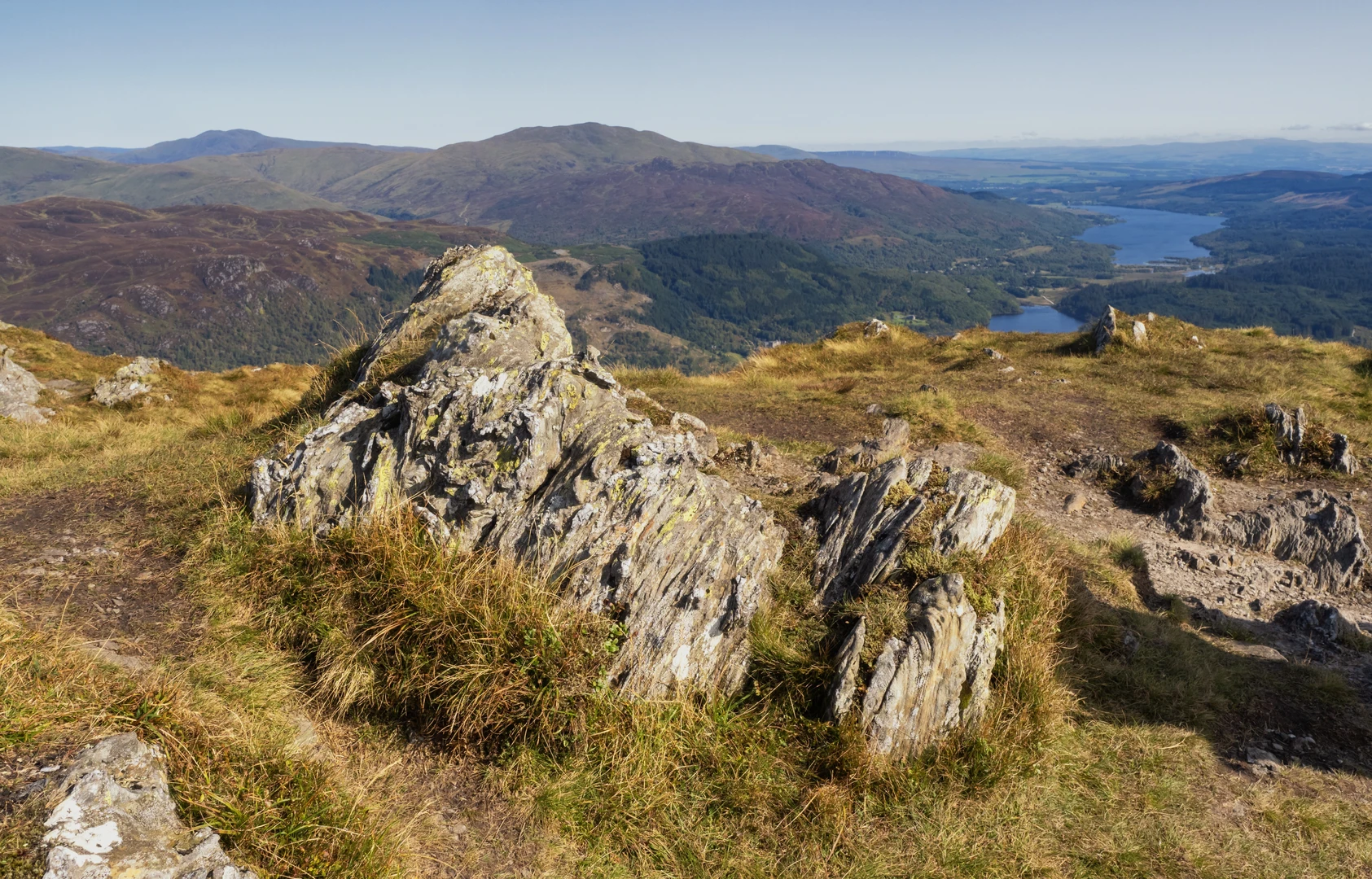
Creag a’ Chaisteil adds a craggy, more rugged feel to the outing. Even where the walking is not technical, the landscape becomes more broken and dramatic, with rocky outcrops, steeper flanks, and a stronger sense of exposure than the lower forested approach. Ben Venue itself reaches about 729 m / 2,392 ft, and although it is not one of Scotland’s highest mountains, it stands in a superb position above the lochs, which is why the views feel outsized for the height gained. (trossachs.co.uk)
On clearer days, the reward is one of the classic Trossachs panoramas: Loch Katrine stretching west, Loch Achray below, Ben A’an across the water, and farther hills stepping away toward Ben Lomond and the wider Highland boundary country. If cloud is low, the summit can be windy, cold, and disorienting, so extra layers and a conservative turnaround mindset matter here more than the “medium” label might suggest. (walkhighlands.co.uk)
Descent, loop character, and key landmarks
The loop format is one of the route’s strengths. Rather than simply retracing the entire ascent, the return gives a changing perspective over the lochs and forest, and the Otter Island side of the circuit adds interest to the lower stages. Around Loch Katrine and Loch Achray, the scenery softens again: water, mixed woodland, marshy edges, and quieter shoreline views replace the harsher summit ground. The island itself is a small but memorable landmark in the loch landscape, and the lower loop helps break up what would otherwise be a straightforward out-and-back mountain day.
Approximate waypoints many hikers find useful are:
- 0 to 2 km / 0 to 1.2 mi: easy to moderate approach on paths/tracks near the car park and watercourses
- **2 to 5 km / 1.2 to 3.1 mi

Surfaces
Unknown
Gravel
Ground
Asphalt
Grass
Comments and Reviews
User comments, reviews and discussions about the Creag a' Chaisteil, Ben Venue and Otter Island Loop, Scotland.
average rating out of 5
0 rating(s)