
Caldeira Loop via Alto do Cabouco, Alto dod Brejo and Alto do Guarda Sol
Download
3D Flyover
Add to list
More
6.9 km
~1 hrs 47 min
242 m
Loop
“A windswept rim walk circles Faial’s dramatic Caldeira, with shifting cloud, crater views, and muddy challenge.”
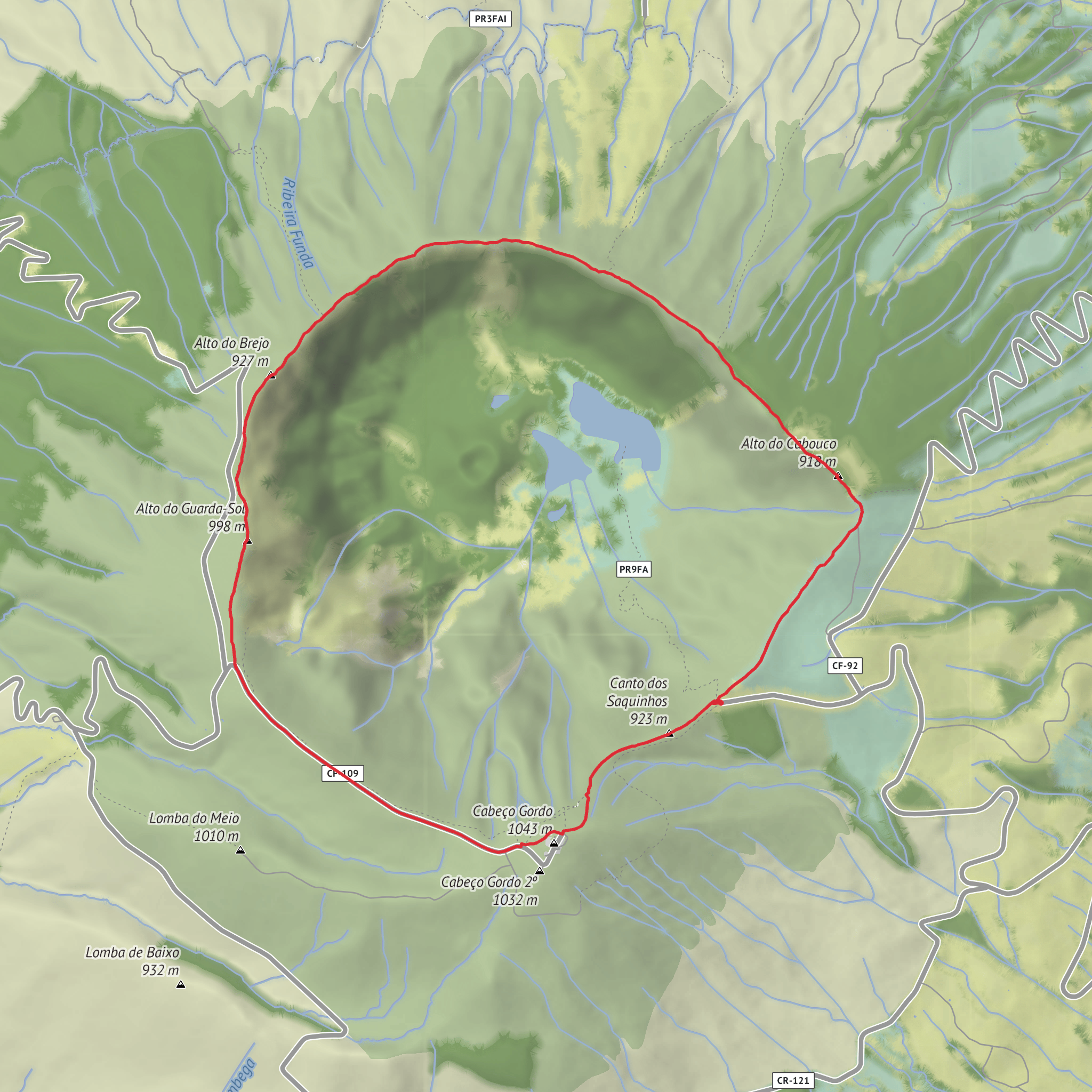
This medium-difficulty loop circles one of Faial’s most important volcanic landscapes, staying high on the rim of the Caldeira and linking the upland points of Alto do Cabouco, Alto do Brejo, and Alto do Guarda Sol. Expect roughly 6.8 to 7 km (4.2 to 4.3 miles) with about 200 m (656 ft) of ascent, although the route feels more demanding than the numbers suggest because it stays exposed at altitude, includes short steep rises, and can be very muddy, windy, and slippery in poor weather. The official trail begins at the Miradouro da Caldeira in central Faial, the main viewpoint and parking area beside the crater access tunnel. (trails.visitazores.com)
The setting is dramatic from the outset. The Caldeira itself is a vast volcanic depression about 2 km (1.2 miles) wide and around 400 m (1,312 ft) deep, formed by ancient eruptions followed by collapse and long volcanic inactivity. The trail runs between roughly 840 m and 1,043 m (2,756 to 3,422 ft) above sea level, so cloud, mist, and sudden weather changes are part of the experience even on otherwise fair days. Visibility can transform the walk: on a clear day the rim gives broad views over Faial’s north and west coasts and into the crater’s lush interior; in fog, the same ground becomes a navigation-focused outing where careful pacing matters. (trails.visitazores.com)
What the route is like
From the viewpoint, the route first passes the small tunnel used to look into the crater, then joins the signed rim path. The walking is a mix of dirt track, grassy volcanic ground, and sections that can become slick after rain. Waymarking on the official circuit is established on site, but because the rim can be misty and intersections connect with longer routes such as PR 06 FAI – Rota dos Dez Vulcões and PR 07 FAI – Caminhos Velhos, it is wise to carry the route in HiiKER before setting out. (trails.visitazores.com)
The first notable high point is Alto do Cabouco, reached at about 1 km (0.6 miles) on several mapped versions of the loop. This shoulder sits near 917–918 m (about 3,009–3,012 ft) and is associated with a geodesic marker and broad interior views when the cloud lifts. From there the trail continues around the rim toward Alto do Brejo, commonly reached around 3.1 to 3.7 km (1.9 to 2.3 miles), then onward toward Alto do Guarda Sol, around 4.0 to 4.4 km (2.5 to 2.7 miles) into the circuit depending on the exact line followed. These are not separate mountain climbs in the alpine sense, but rounded volcanic high points that give the walk its undulating character. (outdooractive.pt)
Near the upper part of the circuit, the route trends toward Cabeço Gordo, the highest point on the trail at 1,043 m (3,422 ft), close to the antenna area mentioned in the official description. This is often where the weather feels most exposed. The descent back toward the starting viewpoint is one of the sections requiring the most care because of the sharper gradient and potentially slick footing. Trekking poles can be useful here, especially if the ground is wet. (trails.visitazores.com)
Landmarks, geology, and natural character
The dominant landmark throughout is the Caldeira do Faial, one of the island’s defining geosites and part of the Nature Reserve of the Caldeira of Faial within the island’s protected landscape. The crater interior is notable for dense, moisture-loving vegetation typical of Azorean laurel forest remnants and high-elevation scrub. Official trail information highlights endemic plants including Azores juniper (*Juniperus brev
Surfaces
Dirt
Asphalt
Unpaved
Unknown
Grass
Comments and Reviews
User comments, reviews and discussions about the Caldeira Loop via Alto do Cabouco, Alto dod Brejo and Alto do Guarda Sol, Portugal.
average rating out of 5
0 rating(s)
