Download
3D Flyover
Add to list
More
2.4 km
~34 min
55 m
Out and Back
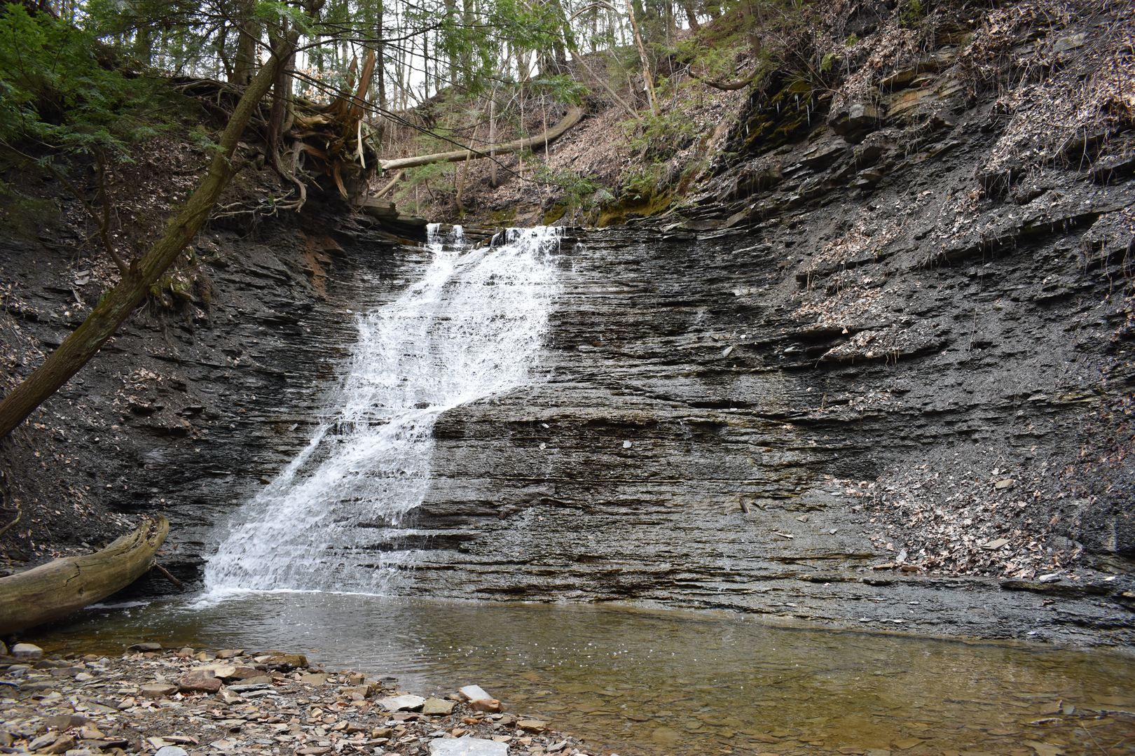
“Slip through hardwood hush into a shaded ravine, where creek-song leads to Buttermilk’s backcountry-feeling falls.”
This is a short, punchy waterfall walk that packs a lot into ~2 km / ~1.2 mi and about ~100 m / ~330 ft of climbing—mostly in a few steeper pitches as you drop into (and climb out of) a shaded ravine. Expect a classic Cuyahoga Valley mix: second-growth hardwood forest, a cool creek corridor, and a waterfall payoff that feels surprisingly “backcountry” for a national park bordered by suburbs.
Getting to the trailhead (car + public transport)
Best practical start point: Boston Mill Visitor Center, 6947 Riverview Road, Peninsula, OH 44264—reliable parking, restrooms, and a clear place to orient before you head to the Buckeye Trail. (nps.gov)
From the visitor center area, you’ll connect toward the Buckeye Trail (blue blazes) and the Blue Hen Falls corridor, then continue to Buttermilk Falls.
By car: Navigate to the Boston Mill Visitor Center address above. Arrive early on weekends—this waterfall corridor is one of the park’s most popular zones, and parking can fill. (parkplanning.nps.gov)
By public transport: The most realistic “transit-assisted” option is the Cuyahoga Valley Scenic Railroad—you can plan around stops like Boston Mill (a flag stop) and then walk to nearby trail connections. Check the railroad’s current schedule and stop rules before committing to this plan. (cvsr.org)
On-trail: what it’s like, step by step
From the Boston Mill area, you’ll ease into the woods on rolling terrain, then the route starts to feel more enclosed as you approach the creek valley. Underfoot is typically packed dirt with roots and short rocky sections; after rain or snowmelt, expect slick mud and wet leaves on the steeper bits.
0.0–0.6 km (0.0–0.4 mi): settling in You’ll be moving through mixed forest typical of the Cuyahoga Valley—oak, maple, beech, and understory shrubs. In spring, the ravines can hold onto cool air and moisture, so it can feel noticeably colder than the parking area.
0.6–1.0 km (0.4–0.6 mi): ravine approach + creek sounds As you near the drainage, the trail begins to undulate more. Listen for the creek; the sound often arrives before you see water. This is where footing can turn slick—roots and slanted clay are common.
1.0–2.0 km (0.6–1.2 mi): Buttermilk Falls area Buttermilk Falls is reached via the Buckeye Trail corridor, but the final approach is often treated as a more informal spur/track near the creek. Stay conservative near the edge: the banks can be undercut, and wet shale/stone gets extremely slippery. Water flow is best in spring and after sustained rain; in dry spells the falls can be reduced to a thinner ribbon.
Key things to watch out for
Steep, slick micro-terrain: Even though the overall stats are modest (~100 m / ~330 ft), the grade concentrates near the ravine. Wet leaves over hardpack can be as slick as ice.
Creekside hazards: Expect muddy margins, unstable edges, and slippery rocks. If you’re hiking with kids, keep them well back from drop-offs and fast water.
Crowds + narrow tread: This is a popular waterfall corridor in Cuyahoga Valley National Park, so anticipate passing traffic and occasional bottlenecks near viewpoints. (parkplanning.nps.gov)
Bugs and ticks: From late spring through summer, mosquitoes and ticks can be active in the shaded, damp ravine environment—use repellent and do a tick check afterward.
Landmarks, nature, and wildlife
You’re hiking in a landscape shaped by water—small tributaries cutting into soft rock layers create these pocket ravines and falls. Wildlife sightings are often subtle rather than dramatic: songbirds in the

Surfaces
Dirt
Unknown
Gravel
Asphalt
Wood
Comments and Reviews
User comments, reviews and discussions about the Buttermilk Falls via Buckeye Trail, Ohio.
average rating out of 5
0 rating(s)