Download
Preview
Add to list
More
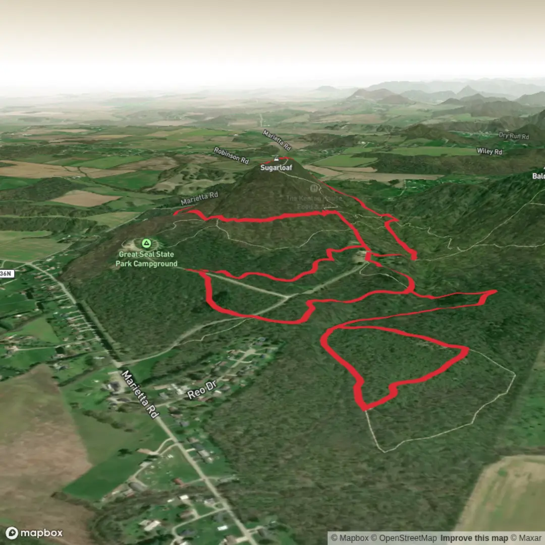
7.5 km
~1 hrs 52 min
223 m
Loop
“Climb through whispering evergreens to a wind-kissed rocky crown, then drift back beside murmuring Spring Run.”
This medium loop/climb packs a lot into a short distance: a steady forested ascent to a broad, rocky summit area with big views, then a quieter return that follows Spring Run through shaded woods. At roughly 7 km (4.3 mi) with about 200 m (656 ft) of gain, it’s a solid half-day outing that feels “earned” without being overly long.
Getting to the trailhead (car + public transport)
Because the start location is listed only as “near” (no coordinates or town/state provided), the best I can do is describe how to plan your approach once you confirm which Sugarloaf Mountain this refers to (there are several in the U.S.).
- By car: Most Sugarloaf trailheads are reached via a small parking area at a state park / natural area entrance or a signed trailhead pull-off on a local mountain road. Plan to arrive early on weekends—popular Sugarloafs can fill up quickly, and roadside parking is often restricted.
- By public transport: If the mountain is near a town with bus or rail service, the usual pattern is:
1) take transit to the nearest downtown station/park-and-ride,
2) use a local bus (if available) toward the park boundary, and
3) finish with a rideshare/taxi for the last few miles (often the only practical option). - Navigation: Once you share the lon/lat (or the nearest town/park name), you can pin the exact start and follow the route cleanly using HiiKER, including confirming parking, trail junctions, and whether the Spring Run segment is a formal trail or a signed connector.
If you paste the coordinates for “Hike head,” I can convert them to the nearest known address/landmark and tailor the directions precisely.
What the route feels like (pace, footing, and grade)
Expect a mostly moderate grade with a few short steeper pitches as you near the top. Over 7 km (4.3 mi) and 200 m (656 ft), the average climb works out to a gentle-to-moderate incline overall, but the trail will likely “stack” the steeper bits near the summit where the terrain turns rockier.
- Footing: Lower slopes are typically packed dirt with roots and occasional rock steps. Near the top, expect rock slabs, loose gravel, or blocky stone where traction matters.
- Time planning: Many hikers will take 2–3.5 hours moving time depending on stops, photo breaks, and how rocky the summit approach is.
- Best seasons: Spring and fall are ideal for cooler temps and clearer views. Summer can be humid with heavier vegetation; winter can turn the upper mountain into an ice-and-wind zone.
Outbound climb: Sugarloaf Mountain Trail to the summit
From the trailhead, the Sugarloaf Mountain Trail usually starts with a gentle warm-up through mixed woods before committing to a more consistent climb.
- 0.0–1.5 km (0.0–0.9 mi): A gradual ascent through forest. Look for early trail markers and any side paths—popular mountains often have “social trails” that can pull you off-route. This is where HiiKER is most useful for staying on the intended line.
- 1.5–3.0 km (0.9–1.9 mi): The climb becomes more sustained. You’ll likely encounter switchbacks or a more direct fall-line climb depending on local trail design. Expect more exposed roots and embedded rock.
- 3.0–3.5 km (1.9–2.2 mi): The final push to the high point is often the steepest and rockiest. If there are slabby sections, they can be slick when wet or leaf-covered.
Landmarks and views: “Sugarloaf” peaks are often named for their rounded, loaf-like profile and commonly feature open ledges or a rocky crown. If the summit area is open, wind exposure can be noticeable even on mild days. Views typically include a patchwork of ridgelines, valleys, and nearby watercourses—especially if the region has river corridors or reservoirs.
Return via Spring Run: shaded descent with water and wildlife
The Spring Run portion tends to feel cooler and more sheltered, trading summit exposure for a corridor of moisture-loving plants and a more relaxed grade.
- 3.5–5.5 km (2.2–3.4 mi): Descending away from the summit, you’ll often re-enter forest quickly. If the route truly follows a run/stream, expect muddy patches, slick rocks, and small crossings after rain.
- 5.5–7.0 km (3.4–4.3 mi): The lower return usually mellows out, with softer grades and more consistent tread as you approach the trailhead.
What to look out for along Spring Run - Wet footing: Even when the rest of the mountain is dry, stream-adjacent trail can stay damp. Trekking poles help on slick roots and stepping stones. - Seasonal flow changes: In spring, the run may be lively and crossings can be splashy; in late summer it may shrink to pools, but mud can remain. - Wildlife: In much of the U.S., this habitat corridor is good for songbirds, woodpeckers, salamanders, frogs, and signs of deer. In bear country, treat the stream corridor as a common travel route—make noise in low-visibility bends and keep food secured.
Historical and regional

Surfaces
Ground
Unpaved
Asphalt
Dirt
Paved
Comments and Reviews
User comments, reviews and discussions about the Sugarloaf Mountain via Sugarloaf Mountain Trail and Spring Run, Ohio.
average rating out of 5
0 rating(s)