Download
3D Flyover
Add to list
More
1.7 km
~21 min
6 m
Loop
“A compact woodland loop threads sandstone ledges and two waterfalls, with beauty heightened by careful footing.”
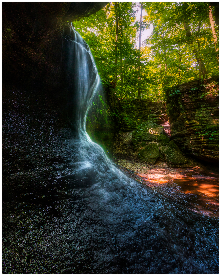
This short loop in Nelson-Kennedy Ledges State Park packs a surprising amount of scenery into roughly 2 km / 1.2 miles, with very little overall elevation gain—about 0 m / 0 ft on paper, though hikers should still expect short uneven rises, shallow dips, roots, rock edges, and damp ground near the waterfalls. The route combines sections of the White Trail and Yellow Trail to link two of the park’s best-known features, Minnehaha Falls and Cascade Falls, in a compact outing that suits families, casual walkers, and anyone looking for a scenic introduction to the ledges country of northeastern Ohio. The nearest practical start is the main parking area off State Route 282 near Ledgewood Drive, Garrettsville, Ohio, at Nelson-Kennedy Ledges State Park. The official park map shows the White and Yellow trails beginning from the SR 282 parking area and identifies both Minnehaha Falls and Cascade Falls along this network. (dam.assets.ohio.gov)
From the trailhead, the walking is generally easy, but “easy” here does not mean flat pavement. The White Trail is the gentler portion of the route and is marked as easy on the official park map, while the Yellow Trail is marked moderate, largely because it passes closer to ledges, tighter rock corridors, and wetter footing near Cascade Falls. The full White Trail is about 0.6 miles / 1.0 km and the Yellow Trail about 0.2 miles / 0.3 km on the current ODNR map, so a combined waterfall-focused loop of around 2 km / 1.2 miles is a reasonable expectation once short connectors and viewing spurs are included. (dam.assets.ohio.gov)
What the route is like
The opening stretch usually feels wooded and enclosed, with the trail moving through a cool beech-maple forest broken by sandstone outcrops and narrow clefts. This park is known for its ledges rather than big climbs, so the terrain tends to undulate gently while the real drama comes from the rock formations around you. The White Trail leads toward Minnehaha Falls, where the stream drops into a rocky cleft below. This section is often the calmer half of the walk, with broad appeal for hikers who want the scenery without committing to the park’s more rugged red and blue routes. (dam.assets.ohio.gov)
As the route transitions onto the Yellow Trail, the setting becomes more rugged and visually striking. Cascade Falls is the larger and more dramatic waterfall on this loop, and the approach passes some of the park’s named rock features, including Dwarf’s Pass, Old Maid’s Kitchen, and Gold Hunter’s Cave, all shown on the official maps. Expect narrow passages, rock walls, and slick surfaces after rain. Even on a short hike, footing deserves attention here, especially where leaves can hide roots or the edges of fissures. (dam.assets.ohio.gov)
Landmarks, geology, and seasonal character
The defining feature of this area is the ledge system itself. ODNR’s geologic map identifies layers including Sharon Conglomerate, Cuyahoga Formation, Berea Sandstone/Bedford Shale, and Ohio Shale, with the park’s unusual passages and cliffs shaped by erosion, jointing, and slumped rock blocks over a long span of geologic time. That geology is what gives the hike its cave-like corridors, cool shaded pockets, and waterfall amphitheaters despite the route’s short length. (dam.assets.ohio.gov)
Water flow can change the character of the hike quite a bit. After wet weather, both falls are more photogenic and the creeks livelier, but mud and slick rock become more likely. In drier periods, the waterfalls may be reduced, and the ledges themselves become the main attraction. Spring and autumn are especially rewarding: spring brings moss, runoff, and fresh woodland growth, while fall opens up views through the trees and highlights the contours of the rock formations. (naturalohioadventures.com)
Wildlife is typical of northeastern Ohio woodland habitat. Hikers may notice songbirds, squirrels, chipmunks, amphibians in damp areas, and a variety of ferns, mosses, and shade-loving plants around the rock clefts. The cool

Surfaces
Dirt
Unknown
Paved
Comments and Reviews
User comments, reviews and discussions about the Cascade and Minnehaha Falls via Yellow Trail and White Trail, Ohio.
average rating out of 5
0 rating(s)