Download
3D Flyover
Add to list
More
1.5 km
~18 min
6 m
Loop
“A gentle woodland loop turns dramatic at the long timber staircase, dropping to Paine Creek’s cool, shaded falls.”
This short loop sits inside Hell Hollow Wilderness Area (Lake Metroparks), starting from the main parking area at 14437 Leroy Center Rd, Thompson, OH 44086. (lakemetroparks.com) It’s often described as “easy” overall because the distance is short and the upper loop is gentle, but the outing has one very specific challenge: a long staircase into (and back out of) the Paine Creek ravine.
Distance & elevation (what “easy” really means here)
Plan on ~2 km (1.2 mi) total, depending on exactly how you connect the loop and spur viewpoints. Elevation gain is frequently estimated low on paper, but expect a notable stair climb: the park’s 262 timber steps drop more than 100 ft (30+ m) into the valley and you’ll regain that on the way out. (lakemetroparks.com) Even with modest “trail” elevation stats, those steps can feel like the hardest part of the hike—especially if they’re damp or leaf-covered.
Getting to the trailhead (car + public transport reality check)
By car:
Navigate to Hell Hollow Wilderness Area and park at the main lot off Leroy Center Road (the address above). (lakemetroparks.com) The trailhead area is developed with a kiosk and typical day-use amenities (helpful if you’re hiking with kids or want a quick pre-hike reset). (trekohio.com)
By public transport:
This is a rural/suburban corner of Lake County; direct public transit to the trailhead is limited. The most workable approach is usually a combination of regional transit to the greater Cleveland/Lake County area plus a rideshare/taxi for the final leg. If you’re planning a car-free day, build in extra time and have a backup plan for the return trip.
On-trail route: Beech Ridge Loop + Wildcat Trail to the falls
From the parking area, pick up the Beech Ridge Loop Trail. This upper loop is wide, well-maintained, and relatively flat, making for an easy warm-up. (trekohio.com) Over roughly the first 0.4–0.8 km (0.25–0.5 mi) you’ll move through mixed woods toward the ravine rim.
A key landmark comes as you near the edge: a fenced overlook along the rim where you can look down into the Paine Creek valley. (trekohio.com) This is a great place to open HiiKER and confirm your next turn, because the descent point is the “commitment” moment of the hike.
The staircase descent (and why it matters)
The route to the waterfall drops via the 262-step staircase, descending 100+ ft (30+ m) to the ravine bottom. (lakemetroparks.com) The steps are the main hazard zone on this hike:
- Slippery conditions: wet leaves, frost, or spring mud can make footing unpredictable.
- Two-way traffic pinch points: pause at wider spots if others are climbing.
- Pacing: treat it like a controlled descent; trekking poles help many hikers here.
At the bottom you’re in the Paine Creek floodplain, where the air often feels cooler and more humid than the rim.
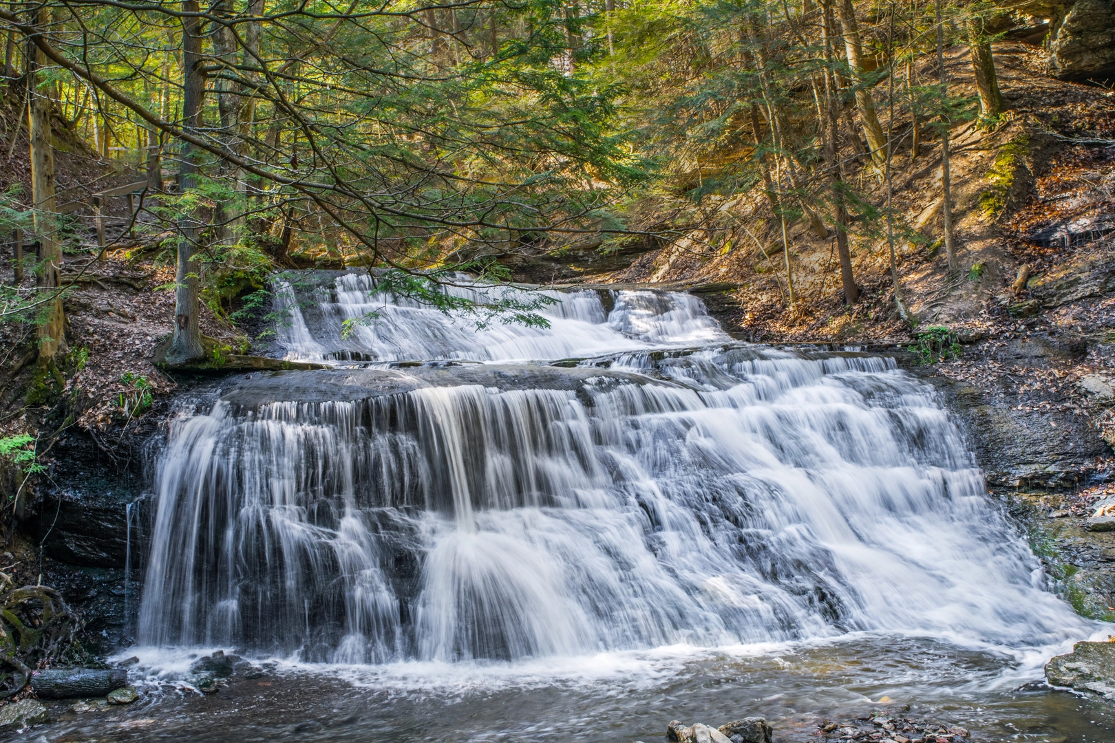
Wildcat Trail along Paine Creek (waterfall segment)
From the base of the stairs, follow the Wildcat Trail, which is narrower and more primitive than the upper loop and gives repeated looks toward Paine Creek. (trekohio.com) This section is short—think a few hundred meters (a few tenths of a mile)—but it’s the most “wild” feeling part of the outing, with creekside vegetation, shaded banks, and occasional muddy patches after rain.
The waterfall(s) in Hell Hollow are tied to the creek’s work cutting into the ravine

Comments and Reviews
User comments, reviews and discussions about the Hell Hollow Waterfall via Beech Ridge Loop Trail and Wildcat Trail, Ohio.
average rating out of 5
0 rating(s)