Download
3D Flyover
Add to list
More
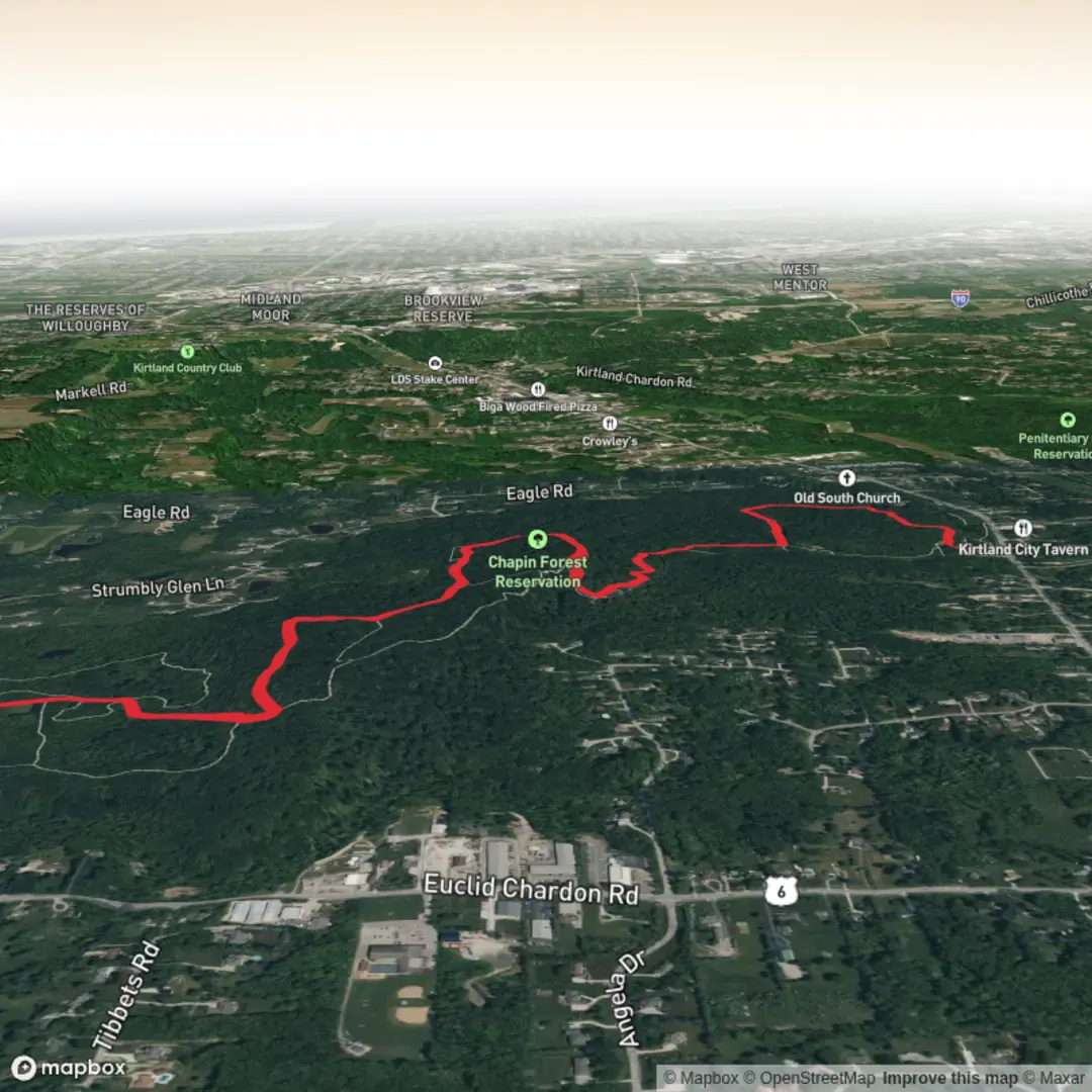
8.0 km
~1 hrs 42 min
71 m
Out and Back
“A gentle woodland wander to a breezy high point, with muddy Turkey Trail moments to mind.”
I’m missing a few key pieces of information needed to make this accurate (especially the trailhead location and what “Turkey Trail” refers to in your area). If you paste the trailhead coordinates (lon/lat) or a HiiKER link, plus the state/province and nearest town, I can convert the coordinates to the nearest known address/landmark and tailor the route description, transit options, and local history correctly.
In the meantime, here’s a planning-ready description that matches your stated stats (~8 km / ~5.0 mi, ~100 m / ~330 ft gain, Easy) and the typical way an “out-and-back or lollipop” summit walk like this is experienced. I’ll tighten every detail (exact turns, landmarks, parking, and any sensitive areas) once you provide the start point.
Expect a relaxed, low-gradient climb through mixed woodland and open patches, with most of the ~100 m (330 ft) gained so gradually you’ll barely notice it until the final approach to the high point. Over ~8 km (5.0 mi), plan on 2–3 hours at an easy pace with time for views and short stops.
The walking is usually on a combination of packed dirt, leaf litter, and short sections of rock or roots. Because the elevation gain is modest, the main challenges tend to be trail wetness, mud, and footing on roots rather than sustained climbing. After rain, the “Turkey Trail” portion is often the slickest—watch for soft ground, shallow puddling, and short muddy runnels where water uses the trail as a drainage line.
Getting to the trailhead (car + public transport approach)
By car: Most trailheads for short summit walks like this are reached via a small pull-off or a modest lot near a local access road. Aim to arrive early on weekends; even easy hikes can fill limited parking quickly. If you share the nearest town/road name or coordinates, I’ll give the closest navigable landmark/address and what to look for at the turn-in (gate, kiosk, bridge, etc.).
By public transport: These trailheads are often not directly served by transit. A common approach is: - Take regional rail/bus to the nearest town center, then - Use a rideshare/taxi for the last few miles/km to the trail access point. If you tell me the nearest town, I can outline the most realistic transit chain and where you’d likely be dropped off safely.
From the trailhead, you’ll typically start on a gentle access path that eases you into the forest. Early on, the route is often wide enough for two people to walk side-by-side, with a steady, comfortable grade. Within the first 1–2 km (0.6–1.2 mi), expect a few subtle junctions where side paths peel off—this is where having HiiKER ready helps you confirm you’re staying on the correct line, especially if leaf cover hides tread.
As you transition onto the Turkey Trail segment, the corridor usually narrows and becomes more “singletrack” in feel. You’ll likely cross a couple of small drainages or seasonally damp spots; these are rarely difficult, but they’re where boots get muddy and where slips happen. If you’re hiking with kids or newer hikers, this is the best place to slow down and keep spacing so nobody gets pushed into awkward footing.
Around 3–4 km (1.9–2.5 mi) in, you’ll generally notice the forest thinning or the terrain subtly changing—more rock underfoot, slightly drier ground, and occasional openings that hint you’re nearing the mountain’s shoulder. The grade may increase briefly, but it should remain consistent with an Easy rating: short, manageable rises rather than a sustained climb.
The summit approach and viewpoints
The final 0.5–1.0 km (0.3–0.6 mi) is usually where the hike “feels” like a mountain walk. Even with only ~100 m (330 ft) total gain, the last stretch often concentrates the most uneven footing: shallow rock steps, roots, or a slightly eroded track. If there’s any wind exposure, you’ll feel it most here—bring a light layer even on warm days.
At or near the high point, expect either: - A small clearing with partial views through trees, or - A more open ledge/knob with broader sightlines. If you share the region, I can call out what you’re likely to see (nearby ridgelines, lakes, towns, or notable peaks) and whether the viewpoint is best in leaf-off seasons.
Wildlife on easy, low-elevation mountain trails is usually more about sign than sightings: tracks in soft ground, scat, and bird activity. In many North American forested areas, common encounters include: - Songbirds and woodpeckers (listen for drumming in spring), - Deer in quieter sections, - Small mammals (squirrels, chipmunks), - Black bears in some regions—rarely seen, but possible; make noise in dense vegetation and keep food secured. Tick presence can be significant in brushy edges and leaf litter. Long socks, repellent, and a post-hike check are smart additions even on an Easy outing.
Plant life depends heavily on your location, but mixed woodland routes often feature seasonal wildflowers in spring and early summer, and colorful understory changes in fall. If the trail passes through any wet pockets, watch for slick wooden planks or stones and avoid widening the trail—step through mud rather than around it when safe to reduce erosion.
For an **8 km (5.0

Surfaces
Unknown
Asphalt
Wood
Comments and Reviews
User comments, reviews and discussions about the Gildersleeve Mountain via Turkey Trail, Ohio.
average rating out of 5
0 rating(s)