Download
Preview
Add to list
More
8.4 km
~1 hrs 47 min
61 m
Loop
“Follow gentle park paths from shimmering lake views to the cool ravine hush of Lower Buckeye Falls.”
This easy loop-style outing links two of Sharon Woods’ best highlights: the ravine scenery around Lower Buckeye Falls and the open-water views around Sharon Woods Lake. Expect a mostly smooth, well-maintained park-trail surface with a few short grades where the path drops into (and climbs out of) the creek corridor. Over roughly 8 km (5.0 mi) you’ll gain about 100 m (330 ft) total—spread out in gentle increments rather than one sustained climb—making it a solid choice for families, casual walkers, and anyone looking for a low-stress nature hike.
Getting to the start (car + public transport)
By car: Aim for the main Sharon Woods access off Cleveland Avenue (US-23) on the north side of Columbus. A practical “nearest known” arrival point for most hikers is Sharon Woods Metro Park – Main Entrance / Ranger Station area near 6911 Cleveland Ave, Columbus, OH 43231 (use that as your navigation anchor, then follow park signs to the closest open lot for the lake and trailheads). Parking is typically in designated lots near the lake/boathouse and main facilities.
By public transport: Central Ohio Transit Authority (COTA) service runs along major corridors like Cleveland Ave, but last-mile access into the park can require a longer walk depending on the route and stop. The most workable approach is usually: - Take a COTA bus that serves Cleveland Ave and get off near the Sharon Woods entrance area, then walk in on park roads/paths to the lake-side lots and trail access. Because routes and stop patterns can change, check the day-of schedule and plan your final approach in HiiKER so you can see the exact distance from your stop to the trail start.
What the route feels like underfoot
Most of the hike is on packed gravel, paved multi-use path, or firm dirt typical of a metro park. After rain, the low areas near the creek and ravine can hold moisture and get slick with leaf litter—still manageable, but it’s where you’ll want shoes with decent tread. The elevation gain is modest overall (~100 m / 330 ft), but you’ll notice it in short bursts when the trail transitions between the lake’s flatter terrain and the creek corridor’s rolling banks.
Plan on 2–2.5 hours at an easy pace with time for stops at the falls and lake viewpoints.
Route breakdown with landmarks (approximate distances)
0.0–1.5 km (0.0–0.9 mi): Lake approach and warm-up Start near the main lake facilities/parking area and ease into the hike on wide, friendly paths. Early on, you’ll get open views across Sharon Woods Lake, with frequent benches and side spurs to the shoreline. This section is nearly flat, ideal for settling into a steady pace.
1.5–3.5 km (0.9–2.2 mi): Transition into the creek corridor As you angle away from the lake, the landscape becomes more wooded. The trail begins to undulate gently as it approaches the ravine system that feeds the falls. You’ll likely cross or parallel small drainages—watch for muddy patches and exposed roots, especially in shaded areas.
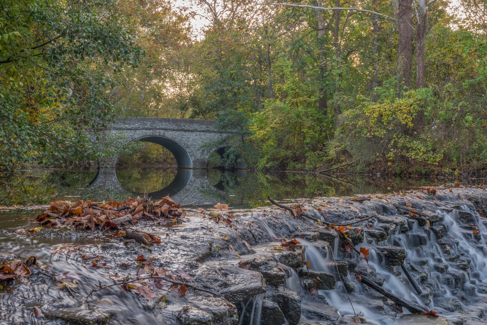
3.5–4.5 km (2.2–2.8 mi): Lower Buckeye Falls area Lower Buckeye Falls is the signature “stop and linger” point. The falls are typically most impressive after wet weather, when the creek has enough volume to create a broader curtain over the rock ledges. Expect: - Short, slightly steeper grades as the trail drops closer to the creek - Damp rock and slick boardwalk/bridge surfaces (if present on your exact line) - A cooler, shaded microclimate in the ravine—noticeable on hot days
Give yourself time here: it’s a natural rest point and a good place to snack, take photos, and listen for birds in the canopy.
4.5–6.5 km (2.8–4.0 mi): Rolling woods back toward the lake Leaving the falls, you’ll climb gradually out of the ravine—this is where most of the day’s “elevation gain” is felt, though it’s still mild. The forest here tends to be a mix of mature hardwoods with seasonal wildflowers in spring and dense green understory in summer. In autumn, leaf cover can hide small rocks and roots, so keep your steps deliberate.
6.5–8.0 km (4.0–5.0 mi): Lake loop finish As you rejoin the lake-side paths, the terrain flattens again. This is a relaxing finish with broad water views and a higher chance of seeing waterfowl close to shore. If you’re timing it near sunset, the lake edge can be breezier and cooler than the woods—bring a light layer if temperatures are dropping.
Nature and wildlife to look for
Sharon Woods sits in a classic central Ohio mix of woodland, wetland edges, and open water, which creates excellent variety for wildlife viewing.
- Birds: Around the lake, look for Canada geese, mallards, herons, and seasonal migrants. In the woods and ravine, listen for woodpeckers, chickadees, and warblers during migration.
- Mammals: White-tailed deer are common, especially in quieter morning and evening hours. You may also spot squirrels, rabbits, and raccoons.
- Reptiles/amphibians: Near wet areas, you can encounter frogs and occasionally turtles sunning near the lake margins.

Surfaces
Unknown
Gravel
Asphalt
Wood
Comments and Reviews
User comments, reviews and discussions about the Lower Buckeye Falls and Sharon Woods Lake in Sharon Woods, Ohio.
average rating out of 5
0 rating(s)